
Wittnau AG
| AG is the abbreviation for the canton of Aargau in Switzerland and is used to avoid confusion with other entries of the name Wittnau . |
| Wittnau | |
|---|---|
 |
|
| State : |
|
| Canton : |
|
| District : | Laufenburg |
| BFS no. : | 4181 |
| Postal code : | 5064 |
| Coordinates : | 640 513 / 258944 |
| Height : | 404 m above sea level M. |
| Height range : | 377–715 m above sea level M. |
| Area : | 11.25 km² |
| Residents: | 1324 (December 31, 2019) |
| Population density : | 118 inhabitants per km² |
|
Proportion of foreigners : (residents without citizenship ) |
9.4% (December 31, 2019) |
| Website: | www.wittnau.ch |
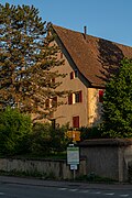
 View of the village center |
|
| Location of the municipality | |
  |
|
Wittnau is a municipality in the Swiss canton of Aargau . It belongs to the district of Laufenburg , is located in the south of the Fricktal region and borders the cantons of Basel-Landschaft and Solothurn .
geography
The street village extends over a kilometer and a half along the Bruggbach, a tributary of the Sissle . The valley is bounded by numerous hills of the Table Jura , which rise steeply in the lower area and merge into partly extensive plateaus in the upper area. An average 650 meter high plain stretches along the western boundary of the municipality, which is divided by numerous deeply cut side valleys. The total of four side valleys are limited by towering, narrow foothills. From north to south these are the Homberg ( 705 m above sea level ), the Wittnauer Horn ( 668 m above sea level ), the Limperg ( 675 m above sea level ) and the Reichberg ( 586 m above sea level ). . A six-kilometer-long side valley branches off to the east of the village and extends to the top of the pass at Benkerjoch . Altenberg ( 589 m above sea level ) in the south separates the Bruggbach valley from the Benkerjochtal.
The area of the municipality is 1125 hectares , of which 608 hectares are covered with forest and 85 hectares are built over. The highest point is 712 m above sea level. M. on the plateau west of the Homberg, the deepest at 385 m above sea level. M. am Bruggbach. The municipality of Wittnau is part of the Aargau Jura Park, a “Regional Nature Park of National Importance”. Neighboring communities are Wegenstetten in the north-west, Gipf-Oberfrick in the north, Wölflinswil in the east, the Solothurn community of Kienberg in the south and the Baselland communities of Anwil and Rothenfluh in the west.
history
The hill fortress on the Wittnauer Horn, which was built during the late Bronze Age (approx. 850–700 BC), is one of the most important testimonies of Swiss prehistory and early history. After a conflagration, the settlement was rebuilt during the Hallstatt period and remained inhabited until the Latène period. The Romans sporadically used the Wittnauer Horn as a refuge after the raids of the Alemanni in the year 260 to around 350. Afterwards it served as part of the Roman fortification of the Rhine. At the beginning of the 5th century, the Romans finally withdrew and left the facility to decay.
Wittnow was first mentioned in a document in the year 1100. The place name comes from the Old High German (ze dero) wittun ouwo and means "by the wide, water-based land". In the Middle Ages the Counts of Homberg-Tierstein ruled the surrounding area. They probably had their ancestral castle built in the 10th century on the eastern slope of the Tiersteinberg (on what is now the municipality of Gipf-Oberfrick ). Around 1100 the Alt-Homberg Castle was built around 600 meters further south . Around 1180, the counts near Büsserach built Neu-Thierstein Castle and moved their center of rule there. After the Counts of Homberg-Tierstein had died out, the Habsburgs took over rule in 1232 . Both castles were destroyed in the Basel earthquake in 1356 .

After the Waldshut War of 1468, the Habsburgs pledged the entire Fricktal to Burgundy . When the Burgundians were defeated by the Confederates during the Burgundian Wars , Wittnau came under Austrian rule again in 1477. After the imperial reform of the Austrian Emperor Maximilian I in 1491, Wittnau belonged to Upper Austria and was located in the Fricktal region, a subordinate administrative unit of the Rheinfelden cameramen (from 1752 in the Upper Office of Breisgau ). In the 17th century there were hardly any longer times of peace. The Rappenkrieg , a peasant uprising, lasted from 1612 to 1614. The Thirty Years' War , which also affected the Fricktal between 1633 and 1638, threw the village back in its development. Foreign troops also moved through the region during the War of the Palatinate Succession (1688–1697).
In 1797 the Fricktal became a French protectorate after the Peace of Campo Formio . During the Second Coalition War , the front line between the armies of France and Austria ran here . On February 20, 1802 Wittnau became a municipality in the Frick district of the Fricktal canton , which joined the Helvetic Republic in August . Wittnau had become Swiss. The municipality has belonged to the canton of Aargau since March 19, 1803. Wittnau remained almost exclusively agricultural until well into the 20th century. The population stagnated for decades. With the disappearance of many small farms, the village turned into a residential community on the edge of the Basel agglomeration . Due to increased construction activity, the population has risen continuously since the mid-1980s.
Attractions

coat of arms
The blazon of the municipal coat of arms reads: "In blue two white, red armored and tongue-tongued eagles placed one above the other." The coat of arms introduced in 1952 is based on that of the Counts of Homberg-Tierstein. It showed two black eagles placed one above the other in yellow, analogous to the municipal coat of arms of Läufelfingen .
population
The population developed as follows:
| year | 1758 | 1850 | 1900 | 1930 | 1950 | 1960 | 1970 | 1980 | 1990 | 2000 | 2010 |
| Residents | 465 | 939 | 815 | 777 | 737 | 741 | 741 | 779 | 909 | 1131 | 1150 |
On December 31, 2019, 1,324 people lived in Wittnau, the proportion of foreigners was 9.4%. In the 2015 census, 52.2% described themselves as Roman Catholic and 17.1% as Reformed ; 30.7% were non-denominational or of other faiths. 92.8% said German as their main language in the 2000 census , 2.7% Albanian , 1.1% Italian and 0.7% Turkish .
Politics and law
The assembly of those entitled to vote, the municipal assembly , exercises legislative power. The executing authority is the five-member municipal council . He is elected by the people in the majority procedure, his term of office is four years. The parish council leads and represents the parish. To this end, it implements the resolutions of the municipal assembly and the tasks assigned to it by the canton. The District Court of Laufenburg is the first instance responsible for legal disputes . Wittnau belongs to the Friedensrichterkreis X (Mettau).
| Municipal council | Official title |
|---|---|
| Andreas von Mentlen | Mayor |
| Anne-Marie Hänggi | Vice-Captain |
| Gertrud Häseli | Councilor |
| Emily Oertelt | Councilor |
| Niklaus Beck | Municipal council |
economy
According to the corporate structure statistics (STATENT) collected in 2015, Wittnau has around 220 jobs, of which 20% in agriculture, 35% in industry and 45% in the service sector. Most of the employed are commuters and work in the larger communities of the Fricktal or in the Aarau region .
Viticulture has always been of great importance . In 2018, an area of 6.3 hectares was planted with vines on the southern slope of the Homberg. Eight different varieties are grown, with Pinot Noir and Riesling × Sylvaner predominating.
traffic
Wittnau lies on Kantonsstrasse 276, which leads from Frick over the Salhöhe to Aarau . About half a kilometer east of the village, Kantonsstrasse 487 branches off over the Benkerjoch to Aarau. The connection to the public transport network is via the Postbus line between the train stations in Aarau and Frick. A night bus runs from Frick via Wittnau to Oberhof .
education
The community has a kindergarten and a schoolhouse where primary school is taught. The secondary school and the Realschule can be attended in Gipf-Oberfrick , the district school in Frick . The closest grammar schools are the Alte Kantonsschule and the Neue Kantonsschule , both in Aarau .
photos

Gym and schoolhouse

Parish hall
Rectory
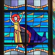
Church window "Jonas"

Main road

Semi-detached farmhouse (1885)

Altbachmühle


Personalities
- Karl Fricker (1870–1933), pioneer of gymnastics
- Bernd Spiessl (1921–2002), professor of maxillofacial surgery
- Werner Uebelmann (1921–2014), cactus dealer and collector
Web links
- Official website of the municipality of Wittnau
- Dominik Sauerländer: Wittnau AG. In: Historical Lexicon of Switzerland .
Individual evidence
- ↑ Cantonal population statistics 2019. Department of Finance and Resources, Statistics Aargau, March 30, 2020, accessed on April 2, 2019 .
- ↑ Cantonal population statistics 2019. Department of Finance and Resources, Statistics Aargau, March 30, 2020, accessed on April 2, 2019 .
- ^ National map of Switzerland, sheet 1069, Swisstopo.
- ↑ Standard area statistics - municipalities according to 4 main areas. Federal Statistical Office , November 26, 2018, accessed on May 11, 2019 .
- ^ Martin Hartmann, Hans Weber: The Romans in Aargau . Verlag Sauerländer, Aarau 1985, ISBN 3-7941-2539-8 , p. 212 .
- ^ Beat Zehnder: The community names of the canton of Aargau . In: Historical Society of the Canton of Aargau (Ed.): Argovia . tape 100 . Verlag Sauerländer, Aarau 1991, ISBN 3-7941-3122-3 , p. 472-473 .
- ^ Joseph Galliker, Marcel Giger: Municipal coat of arms of the Canton of Aargau . Lehrmittelverlag des Kantons Aargau, book 2004, ISBN 3-906738-07-8 , p. 318 .
- ↑ Population development in the municipalities of the Canton of Aargau since 1850. (Excel) In: Eidg. Volkszählung 2000. Statistics Aargau, 2001, archived from the original on October 8, 2018 ; accessed on May 8, 2019 .
- ↑ Resident population by religious affiliation, 2015. (Excel) In: Population and Households, Community Tables 2015. Statistics Aargau, accessed on May 11, 2019 .
- ↑ Swiss Federal Census 2000: Economic resident population by main language as well as by districts and municipalities. (Excel) Statistics Aargau, archived from the original on August 10, 2018 ; accessed on May 8, 2019 .
- ↑ circles of justice of the peace. Canton of Aargau, accessed on June 19, 2019 .
- ↑ Statistics of the corporate structure (STATENT). (Excel, 157 kB) Statistics Aargau, 2016, accessed on May 8, 2019 .
- ↑ Grape harvest control 2018 Canton Aargau. (PDF, 2.4 MB) Agricultural Center Liebegg, 2019, accessed on June 19, 2019 .
Eiken | Frick | Goose singing | Gipf-Oberfrick | Herznach | Hornussen | Kaisten | Laufenburg | Mettauertal | Münchwilen | Oberhof | Oeschgen | Rake hole | Armchairs | Ueken | Wittnau | Wölflinswil | Draw
Former municipalities: Etzgen | Ittenthal | Mettau | Oberhofen | Sulz | Wil
Canton of Aargau | Districts of the Canton of Aargau | Municipalities in the Canton of Aargau