
Büsserach
| Büsserach | |
|---|---|
 |
|
| State : |
|
| Canton : |
|
| District : | Thierstein |
| BFS no. : | 2614 |
| Postal code : | 4227 |
| UN / LOCODE : | CH BSH |
| Coordinates : | 607676 / 248987 |
| Height : | 420 m above sea level M. |
| Height range : | 395–813 m above sea level M. |
| Area : | 7.55 km² |
| Residents: | 2296 (December 31, 2018) |
| Population density : | 304 inhabitants per km² |
| Website: | www.buesserach.ch |
 Büsserach |
|
| Location of the municipality | |
  |
|
Büsserach is a municipality in the Thierstein district in the canton of Solothurn in Switzerland .
geography
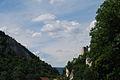
Büsserach lies at 420 m above sea level. M. , 4.5 km southeast of the city of Laufen (linear distance). The clustered village extends in the Lüsseltal, on both sides of the Lüssel , on the southern edge of the Laufen basin in the Jura , in the Schwarzbubenland .
The area of the 7.6 km² large, in west-east direction elongated municipality covers a section of the northern Jura. The northwestern part of the municipality is located in the inner Jurassic Laufen basin. The Lüssel, which enters the basin at Büsserach, crosses the area with a flat valley floor up to 1 km wide from south to north. To the south of the village is the gorge-like narrow point at Thierstein Castle on the Passwangstrasse , where the Lüssel breaks through the chain of Chienberg ( 769 m above sea level ) and Lingenberg ( 760 m above sea level ). The Schlossgut basin to the south of this breakthrough also still belongs to Büsserach. The southern border runs in the Chesselgraben , a right side valley of the Lüsseltal. To the east, the municipality extends to the ridge of the Mettenberg , on which at 813 m above sea level. M. the highest point of Büsserach is reached. In 2014, 12% of the municipal area was in settlements, 46% in forests and woodland, 41% in agriculture and a little less than 1% in unproductive land.
Some individual farms belong to Büsserach. Neighboring communities of Büsserach are Breitenbach , Fehren , Meltingen , Erschwil and Grindel in the canton of Solothurn and Wahlen in the canton of Basel-Landschaft .

population
With 2296 inhabitants (as of December 31, 2018), Büsserach is one of the medium-sized communities in the canton of Solothurn. 92.2% of the residents speak German, 1.9% speak Serbo-Croatian and 1.6% speak Albanian (as of 2000). The population of Büsserach was 670 in 1850 and 654 in 1900. During the 20th century the population increased continuously. Particularly during the 1950s and since 1990 (1646 inhabitants), large growth rates were recorded. Today the settlement area of Büsserach has grown together almost completely with that of Breitenbach.
economy
Until the middle of the 19th century, Büsserach was a predominantly agricultural village. Büsserach was a center for linen weaving until around 1850. In the course of the 19th century, the village developed into the most industrialized municipality in the Schwarzbubenland, only after 1900 it was replaced by Breitenbach. Büsserach was the location of a gypsum and a grain mill and also had a brick factory. The silk twisting mill founded in 1861 (in the Red Factory ) ceased operations in 1932.
Today arable farming , fruit growing (mainly cherry trees) in the Laufen basin, as well as cattle and dairy farming in the higher elevations have only a minor role in the income structure of the population. Numerous other jobs are available in the commercial and service sectors. A larger commercial and industrial area was created on the western edge of the village to the left of the Lüssel. In Büsserach today there are mechanical and metal construction companies, the construction and transport industry, the electrical industry, wood processing, a car company and mechanical workshops. In the last few decades the village has also developed into a residential community. New residential quarters emerged mainly on the promising slopes east of the village center and on the Leimgrubenhübel. Many employees are therefore commuters who work mainly in Laufen and the Basel agglomeration .
traffic
The community is very well developed in terms of transport. It is located on the main road from Zwingen over the Passwang to Balsthal . Büsserach is connected to the public transport network through a post bus course , which covers the route from Laufen to Beinwil .
history
In the Bättlerchuchi , a cave at the southern foot of the Thierstein rock , traces of human life from the Paleolithic ( Magdalenian period ) were discovered. The first written mention of the place took place in 1194 under the name Buezherach . The names Büzracha (1251), Büserach (1295), Busserach (1364), Biesserach (1431) and Büsserach (1538) appeared later . The place name goes back to the Latin personal name Buxurius combined with the Celtic name ending -akos / -acum and thus means good of Buxurius .
Since the Middle Ages , Büsserach was in the sphere of influence of the Beinwil monastery , which had the church set and rich property in the village. Secular rule was exercised by the Counts of Thierstein, but in 1295 the bailiwick rights were also transferred to the monastery. After the battle of St. Jakob an der Birs , Büsserach was visited in 1445 by Austrian troops under Peter von Mörsberg. After the Thierstein family had died out, Büsserach came to Solothurn in 1522 and was assigned to the Thierstein bailiwick. The Solothurn governor had his seat at Neu-Thierstein Castle on the ridge south of the village. During the Thirty Years' War , the village was affected by Swedish troops.
After the collapse of the Ancien Régime (1798), Büsserach was temporarily the capital of a district of the same name during the Helvetic Republic, after which it belonged to the Dornach district and from 1803 to the Thierstein district. In the course of the 19th century, Büsserach developed into a political center and a meeting place for the opposition. The relatively early industrialization compared to the surrounding communities made Büsserach the center of the Solothurnian Laufental from around 1850. It was only after 1900 that it had to give up this position to Breitenbach.
Attractions
The Church of St. Peter probably goes back to an early medieval church. In 1759 a new church was built, but it was demolished in 1951 and replaced by a new building consecrated in 1953. The church tower, built in 1464, has been preserved, has been restored several times and has served as a museum since 1995. The baroque St. Anna chapel west of the village was built in 1684 and has a painted wooden ceiling.
Neu-Thierstein Castle , which was founded around 1100 , sits enthroned on the rocky crest west of the Lingenberg, above the narrow point of the Lüsseltal . In 1997 the entire south-west wall of the castle collapsed. After reconstruction and extensive restoration, the castle was reopened in 2001.
photos

St. Peter's Church

Interior of the church

Church window by Hans Stocker

Main road

center

Lüssel

Schoolhouses

Parish hall
Neu-Thierstein Castle


coat of arms
- In red on green Dreiberg yellow castle (Thierstein seen from the north)
Personalities
- Urs Glutz von Blotzheim (1751–1816), politician and officer
literature
- Gottlieb Loertscher: The art monuments of the canton of Solothurn, Volume III: The districts of Thal, Thierstein, Dorneck. (= Art Monuments of Switzerland. Volume 38). Edited by the Society for Swiss Art History GSK. Bern 1957, DNB 750089342 .
Web links
- Official website of the municipality of Büsserach
- Lukas Schenker: Büsserach. In: Historical Lexicon of Switzerland .
Individual evidence
- ↑ Permanent and non-permanent resident population by year, canton, district, municipality, population type and gender (permanent resident population). In: bfs. admin.ch . Federal Statistical Office (FSO), August 31, 2019, accessed on December 22, 2019 .