Zullwil
| Zullwil | |
|---|---|
| State : |
|
| Canton : |
|
| District : | Thierstein |
| BFS no. : | 2622 |
| Postal code : | 4234 |
| Coordinates : | 612.29 thousand / 248 995 |
| Height : | 592 m above sea level M. |
| Height range : | 522–983 m above sea level M. |
| Area : | 3.66 km² |
| Residents: | 668 (December 31, 2018) |
| Population density : | 183 inhabitants per km² |
| Website: | www.zullwil.ch |
|
Zullwil with Oberkirch parish church |
|
| Location of the municipality | |
Zullwil is a municipality in the Thierstein district of the canton of Solothurn in north-western Switzerland .
geography
Zullwil lies at 592 m above sea level. M. , 9 km east-southeast of the city of Laufen (linear distance). The former street row village extends in a longitudinal hollow of the northern Solothurn Folded Jura , in the headwaters of the Ibach , which flows into the Birs , in the Schwarzbubenland .
The area of the 3.6 km² large municipal area includes a strongly reliefed section of the northern Jura with a great variety of landscapes. The central part of the community is formed by the longitudinal hollow, which extends in a west-east direction, which is a little more than a kilometer wide in the area of the village, but is divided into two by the low ridge of the Hollen . To the south, the municipality extends into the source area of the Ibach with the rugged limestone peaks of Portiflue ( 876 m above sea level ), Geissflue ( 849 m above sea level ) and Regenberg ( 871 m above sea level ). The southeastern border is the Zinglenberg , a leaking north crest of Hirnichopfs and 987 m above sea level. M. the highest point in Zullwil.
In the north the valley basin is bounded by the forest height of the Chilchberg ( 761 m above sea level ). In a narrow corner, the community ban extends northwest to the Eichlenberg . The western boundary is the middle course of the Ibach. In 2014, 10% of the municipal area was in settlements, 47% in forests and woodland, 42% in agriculture and a little less than 1% in unproductive land.
The hamlet of Oberkirch ( 641 m above sea level ) on the saddle between Zullwil and Nunningen as well as various individual farms belong to Zullwil. Zullwil's neighboring communities are Nunningen , Meltingen and Fehren .
population
With 668 inhabitants (as of December 31, 2018), Zullwil is one of the smaller communities in the canton of Solothurn. 94.1% of the residents speak German, 2.5% speak Albanian and 0.7% speak French (as of 2000). The population of Zullwil was 334 in 1850 and 315 in 1900. In the course of the 20th century, the population rose continuously to 604 people by 1970. Since then, only minor population fluctuations have been recorded.
economy
Until the second half of the 20th century, Zullwil was a village dominated by agriculture . Even today, dairy farming , cattle breeding and fruit growing (mainly cherry trees) have a certain role in the income structure of the population. Further jobs are available in local small businesses and in the service sector. An important employer is Gurit (Zullwil) AG , which is active in the production of high-tech fiber composite systems. The March district school is on the border between Zullwil and Meltingen. In the last few decades the village has developed into a residential community. Many workers are therefore commuters who work mainly in the Laufen-Breitenbach region and in the Basel agglomeration .
traffic
The community is located on the connecting road from Laufen via Breitenbach to Nunningen . Zullwil is connected to the public transport network through a Postbus course , which covers the route from Laufen to Nunningen.
history
Various finds suggest that a hilltop settlement must have existed on the Portiflue as early as the Bronze Age and Roman Age . The place was first mentioned in a document in 1152 under the name Zolwilre . Later the names Zulwilr (1386) and Zullwil (1453) appeared. The place name goes back to the Old High German personal name Zullo or Zollo and thus means court settlement of the Zullo / Zollo .
Since the Middle Ages , Zullwil was part of the Gilgenberg rule under the barons of Ramstein. This lordship was sold in 1527 by the lord of the castle, Hans Imer, for 5900 guilders to the city of Solothurn , which converted the area into a bailiwick. Thereafter, Solothurnian bailiffs ruled the Gilgenberg Castle until the French Revolution , which was burned down by the farmers in 1798. After the collapse of the Ancien Régime (1798), Zullwil belonged to the Dornach district during the Helvetic Republic and to the Thierstein district from 1803.
Attractions
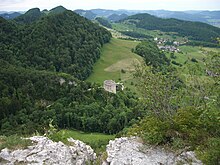
The Catholic parish church and the early Baroque rectory in the hamlet of Oberkirch form an impressive unit. A special eye-catcher is the Gilgenberg castle ruin , which rises on a spur between two source brooks of the Ibach and dates from the early 14th century. The culture club Gilgen organizes an open-air cinema here for one week every year.
coat of arms
- Quartered in black and white, topped with an oblique white under an oblique left black lily stick
The two lilies (in the older Swiss German Gilgen ) go back to the coat of arms of the barons of Ramstein, the builders of Gilgenberg Castle (cf. also with the coats of arms of Bretzwil , Brislach , Nunningen and Zwingen ).
literature
- Gottlieb Loertscher: The art monuments of the canton of Solothurn, Volume III: The districts of Thal, Thierstein, Dorneck. (= Art Monuments of Switzerland. Volume 38). Edited by the Society for Swiss Art History GSK. Bern 1957, DNB 750089342 .
Web links
- Official website of the municipality of Zullwil
- Lukas Schenker: Zullwil. In: Historical Lexicon of Switzerland .
Individual evidence
- ↑ Permanent and non-permanent resident population by year, canton, district, municipality, population type and gender (permanent resident population). In: bfs. admin.ch . Federal Statistical Office (FSO), August 31, 2019, accessed on December 22, 2019 .


