
Fehren
| Fehren | |
|---|---|
 |
|
| State : |
|
| Canton : |
|
| District : | Thierstein |
| BFS no. : | 2616 |
| Postal code : | 4232 |
| Coordinates : | 610 695 / 249486 |
| Height : | 587 m above sea level M. |
| Height range : | 499–662 m above sea level M. |
| Area : | 1.48 km² |
| Residents: | 605 (December 31, 2018) |
| Population density : | 409 inhabitants per km² |
| Website: | www.fehren.ch |
 |
|
| Location of the municipality | |
  |
|
Fehren is a municipality in the Thierstein district in the canton of Solothurn in Switzerland .
geography
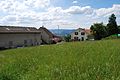
Fehren lies at 587 m above sea level. M. , 6.5 km east-southeast of the city of Laufen (linear distance). The village extends in a promising location on a hill at the northern foot of the Mettenberg , on a slope that slopes down towards the Laufen basin, in the Schwarzbubenland .
The area of the 1.5 km² municipal area covers a section of the northern Jura . The main part of the area is taken up by the slope of Fehren which slopes west towards the inner Jurassic basin of Laufen. To the east, the municipality extends over the Mittlerberg ( 632 m above sea level ) to the Ibach , which forms the eastern border and has created a gorge-like valley between the Mittlerberg and the Eichlenberg. In the south, the municipal ban extends to the slopes of the Mettenberg, where at 660 m above sea level. M. the highest point of Fehren is reached. The southwestern border runs along the Dorfbach von Breitenbach. In 2014, 17% of the municipal area was in settlements, 30% in forests and woodlands and 53% in agriculture.
Some individual farms belong to Fehren. Neighboring communities of Fehren are Zullwil , Meltingen , Büsserach and Breitenbach .
population
With 605 inhabitants (as of December 31, 2018), Fehren is one of the smaller communities in the canton of Solothurn. 96.5% of the residents speak German, 1.8% French and 0.8% speak Turkish (as of 2000). The population of Fehren was 123 inhabitants in 1850, 122 inhabitants in 1900. During the 20th century the population increased continuously. Since 1990 (457 inhabitants) in particular, increased growth rates have been recorded.
economy
Until the second half of the 20th century, Fehren was predominantly an agricultural village. In the 19th century there was a silk spinning mill in Fehren. Even today, dairy farming , animal husbandry and fruit growing (mainly cherry trees) have an important place in the income structure of the population. Other jobs are available in local small businesses and in the service sector, including in mechanical engineering and electrical engineering companies. In the last few decades the village has developed into a residential community thanks to its attractive location. Many employed people are therefore commuters who work mainly in Laufen and Breitenbach as well as in the Basel agglomeration .
traffic
The community is very well developed in terms of transport. It is located on the connecting road from Laufen via Breitenbach to Nunningen . Fehren is connected to the public transport network through a Postbus course , which covers the route from Laufen to Nunningen.
history
The place was first mentioned in a document in 1371 under the name of the court in Ferren . The spellings Ferrer (1458), Feren (1500) and Fehren (1623) appeared later . The place name is derived from the Old High German word fer (fern), whereby the term fern refers to the location of Fehrens seen from Breitenbach or Büsserach.
Fehren has been under the rule of Gilgenberg since the Middle Ages . In 1522 it came to Solothurn and was subsequently assigned to the Thierstein Bailiwick. Fehren only became an independent municipality in 1789, before that it was a district of Breitenbach. After the collapse of the Ancien Régime (1798), the village belonged to the Dornach district during the Helvetic Republic and to the Thierstein district from 1803.
Attractions
The Sankt Ottilienkirche was built in 1967.
photos
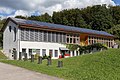
Municipal administration / kindergarten

Primary school building

Landespostmuseum (old post office)

Catholic Church of St. Ottilie

Entrance of Fehren, coming from Breitenbach

Group of houses on the main street
View from the church to the north


coat of arms
- In yellow on each green two-mountain a green pine; the base of the shield is covered with a white house with three black windows, a black door and a red hipped roof
literature
- Gottlieb Loertscher: The art monuments of the canton of Solothurn, Volume III: The districts of Thal, Thierstein, Dorneck. (= Art Monuments of Switzerland. Volume 38). Edited by the Society for Swiss Art History GSK. Bern 1957, DNB 750089342 .
- Ottilia Henz-Hofer: Fehren, the sun terrace. 2011.
Web links
- Official website of the municipality of Fehren
- Lukas Schenker: Fehren. In: Historical Lexicon of Switzerland .
Individual evidence
- ↑ Permanent and non-permanent resident population by year, canton, district, municipality, population type and gender (permanent resident population). In: bfs. admin.ch . Federal Statistical Office (FSO), August 31, 2019, accessed on December 22, 2019 .