
Meltingen
| Meltingen | |
|---|---|
 |
|
| State : |
|
| Canton : |
|
| District : | Thierstein |
| BFS no. : | 2620 |
| Postal code : | 4233 |
| Coordinates : | 611 494 / 248685 |
| Height : | 586 m above sea level M. |
| Height range : | 562–1027 m above sea level M. |
| Area : | 5.76 km² |
| Residents: | 660 (December 31, 2018) |
| Population density : | 115 inhabitants per km² |
| Website: | www.meltingen.ch |
 |
|
| Location of the municipality | |
  |
|
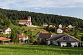
Meltingen is a municipality in the Thierstein district in the canton of Solothurn in Switzerland .
geography

Meltingen lies at 586 m above sea level. M. , 8 km east-southeast of the city of Laufen (linear distance). The village extends in a basin in the headwaters of the Ibach , in the chambered landscape of the Gilgenbergerland , in the folded Jura of the Schwarzbubenland .
The area of the 5.8 km² municipal area covers a section of the northern Jura . The northern part of the municipality is occupied by the Meltingen basin, the Mettenberg ( 813 m above sea level ) in the west, Dich ( 924 m above sea level ) in the south , Horüti and Regenberg ( 871 m above sea level ), in the The east is surrounded by the hill of the Hollen ( 655 m above sea level ). The valley basin is drained by the Ibach to the north to the Birs . In the north, the border lies in the area of the Talenge at Meltingerbrücke between the heights of Mettenberg and Chilchberg. To the south, the municipality extends over the chain of the Meltingerberg to the catchment area of the Lüssel . A narrow strip of the municipal ban extends southeast over the hills of Dürrberg ( 976 m above sea level ) and Chastenchöpfli ( 906 m above sea level ) to the Hirnichopf , on which 1024 m above sea level. M. the highest point of Meltingen is reached. In 2014, 6% of the municipal area was accounted for by settlements, 54% for forests and woodlands and 40% for agriculture.
Various individual farms belong to Meltingen. Neighboring communities of Meltingen are Zullwil , Nunningen , Beinwil (SO) , Erschwil , Büsserach and Fehren .
population
With 660 inhabitants (as of December 31, 2018), Meltingen is one of the smaller communities in the canton of Solothurn. 97.4% of the residents speak German, 0.8% French and 0.7% speak Italian (as of 2000). The population of Meltingen was 411 in 1850 and 363 in 1900. In the course of the 20th century, the population rose to 591 people by 1970. Since then, only minor population fluctuations have been recorded.
politics
Mayor
Werner Hänggi (CVP) was elected mayor for the period from 2009 to 2013. As a result of his resignation in 2011, he will be represented on an interim basis by Vice President Regina Jeger-Borell (FdP) , while the vacated seat on the municipal council will be occupied by Thomas Spaar-Maini. Gérard Zufferey was elected for the next term of office from 2013 to 2016, but he did not receive an absolute majority.
Municipal council
The local council , consisting of 6 seats , which for years has been mainly represented by the FDP and the CVP , takes over the executive . Since the Independent Residents took one seat at the expense of the CVP in 2005 , the distribution of seats has remained unchanged for three terms.
| Political party | 2013-2016 | (+/-) | 2009 - 2012 | (+/-) | 2005 - 2008 | (+/-) | 2001 - 2004 |
|
FDP. The Liberals ( Free Democratic Party until 2009 ) |
3 | 3 | 3 | 3 | |||
| Christian Democratic People's Party | 2 | 2 | 2 | −1 | 3 | ||
| Independent residents | 1 | 1 | 1 | +1 | 0 |
economy
Meltingen was a predominantly agricultural village until the second half of the 20th century . Even today, dairy farming , cattle breeding and fruit growing (mainly cherry trees) have a certain role in the income structure of the population. Further jobs are available in local small businesses and in the service sector. Meltingen is now home to transport companies, carpenters, mechanical workshops and an ecotoxicology laboratory. The March district school is on the border between Meltingen and Zullwil. In the last few decades the village has developed into a residential community. Many workers are therefore commuters who work mainly in the Laufen-Breitenbach region and in the Basel agglomeration .
traffic
The community is located away from the major thoroughfares, but is easily accessible from the connecting road from Breitenbach to Nunningen . Meltingen is connected to the public transport network through a Postbus course , which covers the route from Laufen to Nunningen.
history

Meltingen was first mentioned in a document in 1302, but had been settled since prehistoric times. a. the discovery of a probably megalithic shell stone in 1990 shows. The place name goes back to the Old High German personal name Malto and thus means for the people / the clan of Malto .
Since the Middle Ages, Meltingen has been under the rule of Gilgenberg, which was in the hands of the Barons of Ramstein. Through purchase, the village came to Solothurn with the rule in 1527 and was assigned to the new Gilgenberg bailiwick. After the collapse of the Ancien Régime (1798), Meltingen belonged to the Dornach district during the Helvetic Republic and to the Thierstein district from 1803.
The village has been known as a health resort for its mineral springs since the 15th century. In 1450 the spa and inn were built. The bottling of mineral water began in 1915, and Mineralwasser Aktiengesellschaft Bad Meltingen (renamed Mineralwasser und Heilquellen AG in 1928 ) was founded in 1915 . The Meltinger mineral water was sold until 1988; Sweet drinks under the name Meltina until 1990.
Attractions

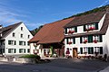
On the Chilchberg, a hill above the village, the pilgrimage church Maria im Hag, mentioned in 1375, stands. The choir and tower of the parish church are in the late Gothic style and date from the 15th century; the nave was rebuilt around 1730. During a renovation in 1968, fragments of wall paintings from around 1460 were discovered. The church also has important stained glass from the 15th century and rich interiors. In the town center, rows of houses with characteristic farms from the 17th to 19th centuries have been preserved.
The historic spa with inn from 1450 has been home to the Bad Meltingen residential group for the disabled since summer 2014 .
Church, Hübel, rectory

former spa house

Parish hall
Unterdorf, main street

Branschtel and Hauptstrasse

District school house


coat of arms
- In yellow on a wavy blue shield base, a blue Madonna and Child, accompanied by two blue lilies
literature
- Gottlieb Loertscher: The art monuments of the canton of Solothurn, Volume III: The districts of Thal, Thierstein, Dorneck. (= Art Monuments of Switzerland. Volume 38). Edited by the Society for Swiss Art History GSK. Bern 1957, DNB 750089342 .
Web links
- Official website of the community of Meltingen
- Lukas Schenker: Meltingen. In: Historical Lexicon of Switzerland .
Individual evidence
- ↑ Permanent and non-permanent resident population by year, canton, district, municipality, population type and gender (permanent resident population). In: bfs. admin.ch . Federal Statistical Office (FSO), August 31, 2019, accessed on December 22, 2019 .
- ^ Meltingen community: Current issues - mutation in the community council / electoral declaration
- ↑ a b Schwarzbubenland municipal elections (Monday, April 15, 2013) ( Memento of the original from August 27, 2014 in the Internet Archive ) Info: The archive link was inserted automatically and has not yet been checked. Please check the original and archive link according to the instructions and then remove this notice. (PDF; 780 kB)
- ^ Meltingen community: parties
- ↑ Municipal elections of May 17, 2009 / election results (PDF; 12 kB)
- ↑ Municipal elections of April 24, 2005 / election results (PDF; 16 kB)
- ↑ a b Municipal council elections 2005 - 2009 / results
- ↑ Bad Meltingen residential group