
Himmelried
| Himmelried | |
|---|---|
 |
|
| State : |
|
| Canton : |
|
| District : | Thierstein |
| BFS no. : | 2618 |
| Postal code : | 4204 |
| Coordinates : | 612 073 / 252392 |
| Height : | 662 m above sea level M. |
| Height range : | 326–793 m above sea level M. |
| Area : | 6.03 km² |
| Residents: | 909 (December 31, 2018) |
| Population density : | 151 inhabitants per km² |
| Website: | www.himmelried.ch |
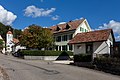
 Himmelried with church and parish hall |
|
| Location of the municipality | |
  |
|
Himmelried is a municipality in the Thierstein district in the canton of Solothurn in Switzerland .
geography


Himmelried is 662 m above sea level. M. , 15 km south of the city of Basel (as the crow flies). The village extends from a panoramic location on a terrace on the southern slope of the Homberg , above the valley of the Chastelbach , on the eastern edge of the Laufen basin, in the folded Jura of the Schwarzbubenland .
The area of the community area of 6.0 km² covers a section of the northern Jura . The eastern part of the municipality is occupied by the Homberg with the Bärtel clearing boiler open to the north and the upstream terraces of Himmelried (in the south) and Eigen or Stollen (in the north). At 793 m above sea level M. , the highest point of Himmelried is reached on the Homberg. The Homberg is bounded to the west by the Chastelbach valley.
The western part of the municipality is bounded by the two parallel valleys of Chastelbach and Ibach ( Kaltbrunnental ), the latter of which is deepened like a gorge into the landscape of the eastern Laufen basin. Both streams flow into the Birs . Between these two valleys a ridge rises, which in Castle Hollen with 660 m above sea level. M. culminates. In 2014, 11% of the municipal area was in settlements, 58% in forests and woodland, 30% in agriculture and a little less than 1% in unproductive land.
The hamlets of Steffen ( 543 m above sea level ), Baumgarten ( 560 m above sea level ) and Schindelboden ( 459 m above sea level ) belong to Himmelried , all at the height between the Kaltbrunnental and the Chastelbachtal, as well as some individual farms. The neighboring communities of Himmelried are Seewen , Nunningen and Breitenbach in the canton of Solothurn and Brislach , Grellingen and Duggingen in the canton of Basel-Landschaft .
population
With 909 inhabitants (as of December 31, 2018), Himmelried is one of the smaller communities in the canton of Solothurn. 94.9% of the residents speak German, 1.2% speak French and 1.0% speak English (as of 2000). The population of Himmelried was 434 inhabitants in 1850 and 458 inhabitants in 1900. During the 20th century, the population always fluctuated between 420 and 480 people. Since 1970 (449 inhabitants) there has been a rapid increase in population combined with a doubling of the population within 30 years.
economy
Up until the second half of the 20th century, Himmelried was a predominantly agricultural village. Even today, dairy farming , animal husbandry and fruit growing (mainly cherry trees) have an important place in the income structure of the population. Further jobs are available in the local small business and in the service sector, including in a company for electric motors and in a joinery. In the last few decades the village has developed into a residential community thanks to its attractive location. In the area around Himmelried as well as near Steffen and Chastel, extensive single-family houses were built. Many workers are therefore commuters who mainly work in the Basel agglomeration .
traffic
The community is located away from the major thoroughfares, the main access is from Grellingen . Himmelried is connected to the public transport network through a Postbus course , which covers the route from Grellingen to Nunningen .
history
Various traces from the Paleolithic and some stray finds from the Roman era have been found in the municipality . The place was first mentioned in a document in 1288 under the name Heimenriet . Later the names Heimenried (1295) and Hymelried (1466) appeared. It was not until the 15th century that the transition from home to heaven took place. The place name probably goes back to the Old High German personal name Haimo and the word reod / riod (clearing). It has the original meaning of clearing the Haimo . The folk etymological interpretation "high (close to the sky) reed (swamp, moor)" is inaccurate. There was also no bog near the village.
Since the Middle Ages, Himmelried has been subordinate to the Counts of Pfeffingen-Thierstein. They sold the village to the Bishop of Basel in 1517 . In 1527, Bishop Himmelried ceded Solothurn and the village was assigned to the Thierstein Bailiwick. After the collapse of the Ancien Régime (1798), Himmelried belonged to the Dornach district during the Helvetic Republic and to the Thierstein district from 1803.
Attractions
The construction of today's church, consecrated to St. Francis Xavier , was approved by the Solothurn Small Council in early 1807 . The church was built soon afterwards and the building may have been completed in the winter of 1807/08, but was not consecrated until 1810 when Bishop Franz Xaver von Neveu, who was residing in Offenburg at that time, visited Himmelried as part of a confirmation and visitation trip . The church replaced the existing All Saints Chapel, which was converted into a school and guard house. A parish of its own had been established for Himmelried as early as 1804; previously the residents of Himmelried to Oberkirch (near Nunningen) were parishes. In 1967/68 the church was renovated, whereby emphasis was placed on preserving the “simple classicism of the early 19th century”. A late Gothic font from 1513 is placed in the church.
In the old town center there are some farmhouses from the 18th and 19th centuries.
photos

Hombergstrasse
Main road

Kirchweg

Himmelried Church
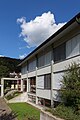
Primary school building


coat of arms
- White juniper tree standing on a green hill in the head of a shield, surrounded by two red six-pointed stars
literature
- Gottlieb Loertscher: The art monuments of the canton of Solothurn, Volume III: The districts of Thal, Thierstein, Dorneck. (= Art Monuments of Switzerland. Volume 38). Edited by the Society for Swiss Art History GSK. Bern 1957, DNB 750089342 .
Web links
- Official website of the community of Himmelried
- Lukas Schenker: Himmelried. In: Historical Lexicon of Switzerland .
Individual evidence
- ↑ Permanent and non-permanent resident population by year, canton, district, municipality, population type and gender (permanent resident population). In: bfs. admin.ch . Federal Statistical Office (FSO), August 31, 2019, accessed on December 22, 2019 .
- ^ Himmelried (Canton of Solothurn) . Local history contributions to the 700th anniversary celebration in 1988. Association "Pro Himmelried", Himmelried 1988, p. 10 .
- ↑ a b Himmelried (Canton Solothurn) . Local history contributions to the 700th anniversary celebration in 1988. Association "Pro Himmelried", Himmelried 1988, p. 214-216 .
- ↑ Marco Jorio: Neveu, Franz Xaver von. In: Historical Lexicon of Switzerland .
- ↑ a b Himmelried (Canton Solothurn) . Local history contributions to the 700th anniversary celebration in 1988. Association "Pro Himmelried", Himmelried 1988, p. 219 .