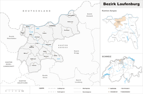
Laufenburg district
| Laufenburg district | |
|---|---|
| Basic data | |
| Country: |
|
| Canton : |
|
| Main town : | Laufenburg |
| FSO number : | 1906 |
| Area : | 156.74 km² |
| Height range : | 289–870 m above sea level M. |
| Residents: | 32,854 (December 31, 2019) |
| Population density : | 210 inhabitants per km² |
| map | |
| Seats in the Grand Council (2016-2020) |
The district of Laufenburg is a district in the canton of Aargau in Switzerland , which essentially consists of the upper Fricktal in the Aargau Jura south of the Rhine . The district comprises 18 municipalities .
After the merger of the municipalities of Wil AG , Oberhofen , Mettau and Etzgen with the Brugger municipality of Hottwil on January 1, 2010 to form the municipality of Mettauertal , the municipal ban of Hottwil came to lie in the Laufenburg district. Thus this has increased by that area.
As of January 1, 2010
Municipalities
| coat of arms | Name of the parish | Population (December 31, 2019) |
Area in km² |
Inhabitant per km² |
|---|---|---|---|---|
| Eiken | 2301 | 7.08 | 325 | |
| Frick | 5607 | 9.96 | 563 | |
| Goose singing | 1052 | 8.77 | 120 | |
| Gipf-Oberfrick | 3650 | 10.17 | 359 | |
| Heart after | 1578 | 6.27 | 252 | |
| Hornussen | 981 | 7.27 | 135 | |
| Kaisten | 2683 | 18.09 | 148 | |
| Laufenburg | 3682 | 14.47 | 254 | |
| Mettauertal | 2034 | 21.59 | 94 | |
| Münchwilen (AG) | 951 | 2.46 | 387 | |
| Oberhof | 591 | 8.20 | 72 | |
| Oeschgen | 1043 | 4.38 | 238 | |
| Rake hole | 684 | 2.77 | 247 | |
| Sisseln | 1595 | 2.52 | 633 | |
| Ueken | 882 | 5.10 | 173 | |
| Wittnau | 1324 | 11.25 | 118 | |
| Wölflinswil | 1040 | 9.51 | 109 | |
| Draw | 1176 | 6.88 | 171 | |
| Total (18) | 32,854 | 156.74 | 210 | |
Changes in the community
- 1803: Eiken → Eiken and Sisseln split off
- 1803: Split from Mettau → Mettau and Wil
- 1803: Split from Wölflinswil → Wölflinswil and Oberhof
- 1803: Split from Herznach → Herznach and Ueken
- 1804: Split from Frick → Frick and Gipf-Oberfrick
- 1832: Split from Mettau → Mettau and Oberhofen
- 1833: Split from Mettau → Mettau and Etzgen
- 1853: Merger of Niederzeihen and the Oberzeihen district of Herznach → Zeihen
- 1866: Merger of Oberleibstadt in the Zurzach district and Unterleibstadt in the Laufenburg district → Leibstadt in the Zurzach district
- 2010: Merger of Hottwil , Etzgen , Mettau , Oberhofen , and Wil → Mettauertal
- 2010: Ittenthal and Kaisten → Kaisten merged
- 2010: Merger of Laufenburg and Sulz → Laufenburg
Localities
| Postcode | Name of the place | local community |
|---|---|---|
| Büren | Goose singing | |
| Were considered | Goose singing | |
| 5083 | Ittenthal | Kaisten |
| Rheinsulz | Laufenburg | |
| 5085 | Sulz | Laufenburg |
| Sulzerberg | Laufenburg | |
| 5275 | Etzgen | Mettauertal |
| 5277 | Hottwil | Mettauertal |
| 5274 | Mettau | Mettauertal |
| 5273 | Oberhofen | Mettauertal |
| 5276 | Wil | Mettauertal |
Web links
Commons : Bezirk Laufenburg - Collection of pictures, videos and audio files
- Platform for the Fricktal
- Andreas Steigmeier : Laufenburg district. In: Historical Lexicon of Switzerland .
Individual evidence
- ↑ Cantonal population statistics 2019. Department of Finance and Resources, Statistics Aargau, March 30, 2020, accessed on April 2, 2019 .
- ↑ Results of the Grand Council elections 2016. State Chancellery of the Canton of Aargau, accessed on July 27, 2020 .
- ↑ Federal Statistical Office Generalized Limits 2020.


