
Heart after
| Heart after | |
|---|---|
 |
|
| State : |
|
| Canton : |
|
| District : | Laufenburg |
| BFS no. : | 4166 |
| Postal code : | 5027 |
| Coordinates : | 646 214 / 258202 |
| Height : | 417 m above sea level M. |
| Height range : | 399–604 m above sea level M. |
| Area : | 6.27 km² |
| Residents: | 1578 (December 31, 2019) |
| Population density : | 252 inhabitants per km² |
|
Proportion of foreigners : (residents without citizenship ) |
16.2% (December 31, 2019) |
| Website: | www.herznach.ch |
 Heart after |
|
| Location of the municipality | |
  |
|
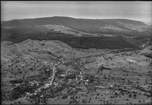
Herznach ( Swiss German : ˈhɛrtsnɑχ ) is a municipality in the Swiss canton of Aargau . It belongs to the Laufenburg district and is located in the southeast of the Fricktal region .
geography
The village is located in the Staffeleggtal , a side valley of the Sissle . The municipality is located in the transition zone between the Table Jura in the north and the Folded Jura in the south. Herznach consists of two parts of the village, the lower village around the church district and the upper village around the former mill. Both grew together in the first half of the 19th century. The narrow valley is bordered by the Halbegschneid ( 531 m above sea level ) in the west, the Egg ( 604 m above sea level ) in the southwest, the Sarbe ( 540 m above sea level ) in the southeast and the Dürreich ( 509 m above sea level ) above sea level ) in the northeast. Two valleys branch off from the main valley: To the east, the Startlebach valley extends to the plateau between Dürreich and Sarbe. The Haugertal leads between Halbegschneid and Egg through to the extensive Kornberg plain in the west.
The area of the municipality is 627 hectares , of which 156 hectares are forested and 83 hectares are built over. The highest point is on the summit of the Egg, the lowest at 405 m above sea level. M. am Staffeleggbach. The municipality of Herznach is part of the Aargau Jura Park, a "Regional Nature Park of National Importance". Neighboring communities are Ueken in the north, Zeihen in the east, Densbüren in the south, Wölflinswil in the west and Gipf-Oberfrick in the north-west.
history

Individual finds indicate a settlement during the Neolithic and the time of the Roman Empire . Hercenahc was first mentioned in a document in 1097. The place name comes from the late Latin (praedium) Artinacum and means "estate belonging to Artinius". The sovereignty was originally with the Counts of Homberg, from 1306 at the latest with the Habsburgs . A ministerial family named itself after Herznach in the 12th and 13th centuries . Your castle, which was built on the foundations of a manor house from the 7th to 10th centuries, collapsed in the Basel earthquake in 1356 ; the location is assumed to be on the church hill.
After the Waldshut War of 1468, the Habsburgs pledged the entire Fricktal to Burgundy . When the Burgundians were defeated by the Confederates during the Burgundian Wars , Herznach came under Austrian rule again in 1477. After the imperial reform of Emperor Maximilian I in 1491, Herznach belonged to Upper Austria and was located in the Fricktal region, a subordinate administrative unit of the Rheinfelden cameramen (from 1752 in the Breisgau district ).
During the Swabian War of 1499, troops from Bern and Freiburg marched through the villages north of Staffelegg and down to Frick . From 1502, Herznach was on the border with the Bernese Aargau , after Bern had taken possession of the neighboring village of Densbüren to the south . In the 17th century there were hardly any longer times of peace. The Rappenkrieg , a peasant uprising, lasted from 1612 to 1614. The Thirty Years War , which also affected the Fricktal between 1633 and 1638, threw the village back in its economic development. Foreign troops also moved through the region during the War of the Palatinate Succession (1688–1697). Iron ore was mined in Herznach until the beginning of the 19th century .
In 1797 the Fricktal became a French protectorate after the Peace of Campo Formio . During the Second Coalition War , the front line between the armies of France and Austria ran here . On February 20, 1802, Herznach became a municipality in the Frick district of the Fricktal canton , which joined the Helvetic Republic in August . The municipality has belonged to the canton of Aargau since March 19, 1803. In 1853 the hamlet of Oberzeihen separated from Herznach and merged with Zeihen . After the population stagnated for decades, it has been rising continuously since the late 1970s.
In 1207, iron ore mines in the Fricktal were first mentioned in a document. In the period between 1200 and 1850, miners extracted an estimated 275,000 tonnes of ore. Later, in the course of the 18th century, ore extraction practically came to a standstill between Wölflinswil and Herznach. After an interruption of more than 150 years, the mining of Dogger ore was resumed in 1937 . In Switzerland, however, there was no suitable blast furnace , which is why the ore was exported to the German Ruhr area in the first few years and smelted there. Because of the imminent danger of war, the ore deposit was again considered worthy of mining. The annual output reached a maximum of 210,000 tons in 1941. It then fell to 50,000 tons per year, until the mine finally had to be shut down in 1967 for economic reasons, as the iron content was only around 30% and the extraction costs were disproportionately high. Today a silo tower bears witness to the mining past. The mine and the tunnel have been open to visitors since September 2016. A museum brings the earlier ore mining closer and at the weekend the mine train is available for a trip through the area.
Attractions
Herznach's landmark is the Catholic parish church of St. Niklaus, which is built in the form of a fortified church . The monument of national importance, surrounded by a wall, has existed since at least 1180. The right of patronage was transferred from Habsburg in 1407 to Rheinfelden Abbey . The nave and the church tower were rebuilt in 1651, the choir from 1718 to 1719 (with frescoes by Francesco Antonio Giorgioli ). In the years 1732 and 1776/78 an expensive interior work was carried out in the Baroque style , with Johann Isaak Freitag creating the high altar and pulpit figures (including the Saints St. Nicholas and St. Martin). A Josephine savings coffin is kept in the ossuary .
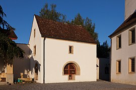
The chapel dedicated to Saint Verena is considered the oldest church in the entire Fricktal. It was built in 1516 on top of the 10th century foundations.

Ossuary, church and rectory
Ossuary

St Verena Chapel

Old school house

Primary school building


coat of arms
The blazon of the municipal coat of arms reads: "In red, green Verenakrüglein with yellow handle." No coat of arms has come down to us from the Lords of Herznach. That is why in 1953 the congregation chose the jug, one of the symbols of Saint Verena , the patron saint of the Herznach church. The old coat of arms, pointing to the right, was changed by a municipal resolution. Today the spout of the Verena jug is directed to the left.
population
The population developed as follows:
| year | 1768 | 1850 | 1900 | 1930 | 1950 | 1960 | 1970 | 1980 | 1990 | 2000 | 2010 |
| Residents | 478 | 898 | 639 | 654 | 665 | 654 | 697 | 761 | 992 | 1059 | 1328 |
On December 31, 2019, 1578 people lived in Herznach, the proportion of foreigners was 16.2%. In the 2015 census, 43.0% described themselves as Roman Catholic and 23.3% as Reformed ; 33.7% were non-denominational or of other faiths. In the 2000 census, 96.5% said German as their main language and 1.7% Albanian .
Politics and law
The assembly of those entitled to vote, the municipal assembly , exercises legislative power. The executing authority is the five-member municipal council . He is elected by the people in the majority procedure, his term of office is four years. The parish council leads and represents the parish. To this end, it implements the resolutions of the municipal assembly and the tasks assigned to it by the canton. The District Court of Laufenburg is the first instance responsible for legal disputes . Herznach belongs to the Friedensrichterkreis X (Mettau).
| Municipal council | Official title |
|---|---|
| Thomas Treyer | Mayor |
| Catherine Gasser | Vice-Captain |
| Stephan Gemmet | Municipal council |
| Pavel Roth | Municipal council |
| Hansruedi Rubin | Municipal council |
economy
According to the company structure statistics (STATENT) collected in 2015, there are around 410 jobs in Herznach, 16% of them in agriculture, 28% in industry and 56% in the service sector. The main companies are a textile ribbon factory and an advertising balloon company. Most of the employed are commuters and work in the larger communities of the Fricktal and in the Aarau region .
Viticulture has always been of great importance . On the southern slopes of Halbegschneid and Sarbe, an area of 7.3 hectares was planted with vines in 2018. A dozen varieties are grown, with Blauburgunder , Riesling × Sylvaner and Sauvignon Blanc predominating.
traffic
Herznach is located on Hauptstrasse 24 across Staffelegg , the most important connection between Aarau and the Fricktal. Kantonsstrasse 480/482 leads via Zeihen to Effingen on Bözbergstrasse . Four kilometers north of Herznach there is a motorway connection to the A3 near Frick . The connection to the public transport network is made by two postbus lines : The main line runs from Aarau train station to Frick, another line connects Herznach with Effingen. On weekends there is a night bus from Frick via Effingen and Herznach to Densbüren . The Oberfricktaler Eisenweg runs through the village .
education
The community has a kindergarten and a school house where primary school is taught. All upper levels ( district school , secondary school and junior high school ) can be attended in Frick . The closest grammar schools are the Alte Kantonsschule and the Neue Kantonsschule , both in Aarau .
Web links
- Official website of the municipality of Herznach
- Dominik Sauerländer: Herznach. In: Historical Lexicon of Switzerland .
- History of Herznach
Individual evidence
- ↑ Cantonal population statistics 2019. Department of Finance and Resources, Statistics Aargau, March 30, 2020, accessed on April 2, 2019 .
- ↑ Cantonal population statistics 2019. Department of Finance and Resources, Statistics Aargau, March 30, 2020, accessed on April 2, 2019 .
- ↑ a b Beat Zehnder: The community names of the canton of Aargau . In: Historical Society of the Canton of Aargau (Ed.): Argovia . tape 100 . Verlag Sauerländer, Aarau 1991, ISBN 3-7941-3122-3 , p. 194-196 .
- ^ National map of Switzerland, sheet 1069, Swisstopo.
- ↑ Standard area statistics - municipalities according to 4 main areas. Federal Statistical Office , November 26, 2018, accessed on May 11, 2019 .
- ↑ History. bergwerksilo.ch, archived from the original on October 22, 2018 ; accessed on May 9, 2019 .
- ^ Ore mining in the Fricktal. fricktal.ch, archived from the original on July 15, 2009 ; Retrieved January 26, 2010 .
- ↑ Peter Felder: Parish Church St. Nikolaus Herznach AG. (Swiss Art Guide, No. 375). Ed. Society for Swiss Art History GSK. Bern 1985.
- ↑ St. Nikolaus Church Herznach ( Memento from February 28, 2014 in the Internet Archive )
- ↑ Linus Hüsser: The Herznacher "Pestsarg". A witness of the Josephine reform policy, in: Vom Jura zum Schwarzwald 72 (1998), pp. 59–62.
- ^ Joseph Galliker, Marcel Giger: Municipal coat of arms of the Canton of Aargau . Lehrmittelverlag des Kantons Aargau, book 2004, ISBN 3-906738-07-8 , p. 175 .
- ↑ Population development in the municipalities of the Canton of Aargau since 1850. (Excel) In: Eidg. Volkszählung 2000. Statistics Aargau, 2001, archived from the original on October 8, 2018 ; accessed on May 8, 2019 .
- ↑ Resident population by religious affiliation, 2015. (Excel) In: Population and Households, Community Tables 2015. Statistics Aargau, accessed on May 11, 2019 .
- ↑ Swiss Federal Census 2000: Economic resident population by main language as well as by districts and municipalities. (Excel) Statistics Aargau, archived from the original on August 10, 2018 ; accessed on May 8, 2019 .
- ↑ circles of justice of the peace. Canton of Aargau, accessed on June 19, 2019 .
- ↑ Statistics of the corporate structure (STATENT). (Excel, 157 kB) Statistics Aargau, 2016, accessed on May 8, 2019 .
- ↑ Grape harvest control 2018 Canton Aargau. (PDF, 2.4 MB) Agricultural Center Liebegg, 2019, accessed on June 19, 2019 .
Eiken | Frick | Goose singing | Gipf-Oberfrick | Herznach | Hornussen | Kaisten | Laufenburg | Mettauertal | Münchwilen | Oberhof | Oeschgen | Rake hole | Armchairs | Ueken | Wittnau | Wölflinswil | Draw
Former municipalities: Etzgen | Ittenthal | Mettau | Oberhofen | Sulz | Wil
Canton of Aargau | Districts of the Canton of Aargau | Municipalities in the Canton of Aargau