
Densbueren
| Densbueren | |
|---|---|
 |
|
| State : |
|
| Canton : |
|
| District : | Aarau |
| BFS no. : | 4004 |
| Postal code : | 5026 |
| UN / LOCODE : | CH DBU |
| Coordinates : | 646 371 / 256113 |
| Height : | 474 m above sea level M. |
| Height range : | 431–866 m above sea level M. |
| Area : | 12.52 km² |
| Residents: | 724 (December 31, 2019) |
| Population density : | 58 inhabitants per km² |
|
Proportion of foreigners : (residents without citizenship ) |
10.4% (December 31, 2019) |
| Website: | www.densbueren.ch |
 Densbueren |
|
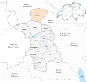
| Location of the municipality | |
  |
|
Densbüren ( Swiss German Däischbere [ˈdæɪʃbərə] ) is a municipality in the Swiss canton of Aargau . It belongs to the Aarau district and is located north of Staffelegg in the Fricktal region .
geography
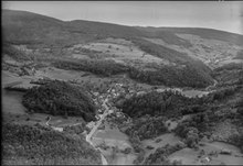
The municipality in the Staffeleggtal is geographically completely different from the rest of the municipalities in the district. It is the only municipality that is not located on the plain of the river valleys of Aare , Suhre and Wyna , but separated by the 621 meter high Staffeleggpass in the middle of the southernmost Jura chain . The area is drained by the Staffeleggbach .
Densbüren is surrounded on three sides by steep, wooded Jura hills: In the east rise the Würz ( 801 m above sea level ), the Homberg ( 782 m above sea level ) and the Hard ( 770 m above sea level ), in the South the Staffelegg, the Herzberg ( 750 m above sea level ) and the Asperstrihe ( 838 m above sea level ). The Strihe in the west is 867 m above sea level. M. the second highest point of the Aargau and the highest mountain in the canton. Around one kilometer south of Densbüren, in a short side valley at the foot of the Asperstrihe, is the district of Asp. There are also numerous scattered individual farms on the mountain slopes, in the Stockmatt above Benken and in the Sulzbann on the upper reaches of the Zeiherbach, between the Homberg and the Bann flows through the area of Densbüren.
The area of the municipality is 1252 hectares , of which 691 hectares are forested and 65 hectares are built over. The highest point is the summit of the Strihe, the lowest is at 430 meters on the Staffeleggbach. The municipality is part of the Aargau Jura Park , a “regional nature park of national importance” . Neighboring communities are Herznach in the north, Zeihen in the northeast, Thalheim in the east, Küttigen in the south and Oberhof and Wölflinswil in the west.
history
The first written mention of the village was in 1426 as Teinspuiren . The place name comes from the Old High German Taninesburron and means "at the houses of the Tanin". Urgiz Castle near Densbüren was mentioned as early as 1277 and was owned by the Lords of Uriols. These had received the small lordship of Urgiz, which included Densbüren as well as Asp, from the diocese of Strasbourg as a fief. The Basel earthquake of 1356 caused great damage, after which the castle fell apart. In 1429 the Effinger from Brugg acquired the rule, in 1444 the Rätz from Säckingen followed and finally in 1475 the Hasfurter from Lucerne .
In 1502, Bern acquired the Urgiz rule and added it to the Schenkenberg office . Thus, Densbüren was part of the subject area known as Bernese Aargau . The Bernese thereby secured the strategically important Staffelegg pass crossing on the border with Upper Austria . The Reformation was introduced in 1528. The governor of Aarau had Dogger ore that had been acquired black from the neighboring village of Herznach smelted in Densbüren, which meant that the place had a secure income until the middle of the 17th century. When the Austrian government rigorously stopped the black market, Densbüren fell into a severe economic crisis. Many residents were therefore forced to serve as mercenaries abroad.
In March 1798 the French took Switzerland, disempowered the federal estates and established the Helvetic Republic . Since then, Densbüren has belonged to the canton of Aargau, the neighboring communities in Fricktal , which remained Catholic, followed in 1803. In 1810, the canton had the road over Staffelegg expanded, which enabled the villagers to offer harnessing services for horse and carts. However, this branch of industry disappeared with the opening of the railway lines at Hauenstein and Bözberg. Viticulture , which has been practiced since 1859, offered a way out in addition to emigration . In the middle of the 19th century, Yenish families were naturalized on the basis of the law «to combat homelessness» . Between 1850 and 1980 the population decreased by more than half, since then it has increased slightly again.
Attractions
.JPG)

The Urgiz ruin is located northeast of the village at an altitude of 577 m above sea level. M. on a narrow and steep rock ridge, more than 120 meters above the valley floor. The remains of the wall were uncovered and preserved in 1996/97. The Reformed Church in Densbüren was built between 1552 and 1558. The simple, late Gothic building stands a little higher on the slope of the Rüdlenberg. The colored glass windows in the church are by the Aargau artist Werner Sommer. Until 1642 Densbüren belonged to the parish of Elfingen and has been an independent parish ever since. Below the village, next to the Staffeleggbach, is the historic sawmill of Densbüren. It is operated with hydropower; the water is led from the stream through a canal and over the overshot water wheel. The machine consists of a single-blade frame saw. Since the renovation in 2002, the saw has been used occasionally for demonstrations. In the valleys of Densbüren there are some former Swiss army barriers next to the streets.
coat of arms
The blazon of the municipal coat of arms reads: "In white with a red border, green fir on a green three-mountain." The seal picture introduced in 1811 also showed a fir tree on Dreiberg , but in a blue field and without a border. In 1949 a heraldic correct redesign took place. The red border was chosen to avoid confusion with other municipal coats of arms and to remind of the village's earlier affiliation to the diocese of Constance .
population
The population developed as follows:
| year | 1764 | 1803 | 1850 | 1900 | 1930 | 1950 | 1960 | 1970 | 1980 | 1990 | 2000 | 2010 |
| Residents | 469 | 666 | 1,167 | 934 | 826 | 772 | 715 | 664 | 596 | 717 | 721 | 708 |
On December 31, 2019, 724 people lived in Densbüren, the proportion of foreigners was 10.4%. In statistical surveys from 2015, 56.4% described themselves as Reformed and 12.8% as Roman Catholic ; 30.8% were non-denominational or of other faiths. 98.2% said German as their main language in the 2000 census .
Politics and law
The assembly of those entitled to vote, the municipal assembly , exercises legislative power. The executing authority is the five-member municipal council . He is elected by the people in the majority procedure, his term of office is four years. The parish council leads and represents the parish. To this end, it implements the resolutions of the municipal assembly and the tasks assigned to it by the canton. The Aarau District Court is the first instance responsible for legal disputes . Densbüren belongs to the Friedensrichterkreis I (Aarau).
In the 2010s, the municipality of Densbüren examined a possible merger with other municipalities in the region. One variant was the merger with neighboring communities in the Fricktal. On December 15, 2019, a vote on a preliminary study on the merger with Herznach and Ueken took place in Densbüren. With a turnout of 64.5 percent, the project was rejected with around two thirds of the votes against. In addition, the community of Densbüren is involved in the merger project Zukunftsraum Aarau, in which the city of Aarau and the communities of Suhr , Oberentfelden and Unterentfelden also participate.
economy
According to the company structure statistics (STATENT) collected in 2015, there are around 300 jobs in Densbüren, of which 24% are in agriculture, 26% in industry and 50% in the service sector. Almost two thirds of all employed people are commuters and work in Aarau or in the communities of the Fricktal . The Herzberg conference center is of supraregional importance .
traffic
Densbüren is located on the pass road over the Staffelegg , which leads from Aarau to Frick ( Hauptstrasse 24 ). These two places are connected by a post bus line. From the top of the pass, where there is an inn, a road leads over height 658 to Thalheim . The hamlet of Asp can be reached via a side street that continues to Herzberg and Staffelegg. In the southwest, the area extends from Densbüren to the Benkerjoch pass . A road leads across the watershed at Strihen to Wölflinswil . On weekends there is a night bus from Frick via Effingen and Densbüren to Asp.
education
The community has a kindergarten and a schoolhouse where the primary school teaches. The Realschule , the Secondary School and the District School can be attended in Frick . The closest grammar schools are the Alte Kantonsschule and the Neue Kantonsschule , both in Aarau .
Personalities
- Clara Müller (1862–1929), painter
literature
- Alfred Lüthi: Densbüren. In: Historical Lexicon of Switzerland .
- Michael Stettler : The art monuments of the canton of Aargau . Ed .: Society for Swiss Art History . Volume I: The districts of Aarau, Kulm, Zofingen. Wiese Verlag, Basel 1948, DNB 366495623 .
Web links
Individual evidence
- ↑ Cantonal population statistics 2019. Department of Finance and Resources, Statistics Aargau, March 30, 2020, accessed on April 2, 2019 .
- ↑ Cantonal population statistics 2019. Department of Finance and Resources, Statistics Aargau, March 30, 2020, accessed on April 2, 2019 .
- ↑ a b Beat Zehnder: The community names of the canton of Aargau . In: Historical Society of the Canton of Aargau (Ed.): Argovia . tape 100 . Verlag Sauerländer, Aarau 1991, ISBN 3-7941-3122-3 , p. 73-74 .
- ↑ a b National map of Switzerland, sheet 1069, Swisstopo.
- ↑ Standard area statistics - municipalities according to 4 main areas. Federal Statistical Office , November 26, 2018, accessed on May 17, 2019 .
- ^ Stettler: The art monuments of the Canton of Aargau, Volume I: The districts of Aarau, Kulm, Zofingen. Pp. 140-142.
- ^ Joseph Galliker, Marcel Giger: Municipal coat of arms of the Canton of Aargau . Lehrmittelverlag des Kantons Aargau, book 2004, ISBN 3-906738-07-8 , p. 139 .
- ↑ Population development in the municipalities of the Canton of Aargau since 1850. (Excel) In: Eidg. Volkszählung 2000. Statistics Aargau, 2001, archived from the original on October 8, 2018 ; accessed on May 17, 2019 .
- ↑ Resident population by religious affiliation, 2015. (Excel) In: Population and Households, Community Tables 2015. Statistics Aargau, accessed on May 17, 2019 .
- ↑ Swiss Federal Census 2000: Economic resident population by main language as well as by districts and municipalities. (Excel) Statistics Aargau, archived from the original on August 10, 2018 ; accessed on May 17, 2019 .
- ↑ circles of justice of the peace. Canton of Aargau, accessed on June 21, 2019 .
- ↑ Statistics of the corporate structure (STATENT). (Excel, 157 kB) Statistics Aargau, 2016, accessed on May 17, 2019 .
Aarau | Biberstein | Box | Densbueren | Erlinsbach | Gränichen | Hirschthal | Küttigen | Mooing | Oberentfelden | Suhr | Unterentfelden
Former municipality: Rohr
Canton of Aargau | Districts of the Canton of Aargau | Municipalities in the Canton of Aargau