
Oberentfelden
| Oberentfelden | |
|---|---|
 |
|
| State : |
|
| Canton : |
|
| District : | Aarau |
| BFS no. : | 4010 |
| Postal code : | 5036 |
| UN / LOCODE : | CH OFE |
| Coordinates : | 645 933 / 245151 |
| Height : | 414 m above sea level M. |
| Height range : | 406–597 m above sea level M. |
| Area : | 7.16 km² |
| Residents: | 8492 (December 31, 2019) |
| Population density : | 1186 inhabitants per km² |
|
Proportion of foreigners : (residents without citizenship ) |
31.8% (December 31, 2019) |
| Website: | www.oberentfelden.ch |
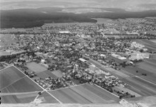
 Oberentfelden with the church |
|
| Location of the municipality | |
  |
|
Oberentfelden ( Swiss German : ˈɔbərˌæmpfæʊd ) is a municipality in the Swiss canton of Aargau . It belongs to the Aarau district , is located in the lower Suhrental and borders the canton of Solothurn .
geography
The municipality extends from the wooded range of hills Schornig ( 596 m above sea level ) in the east across the approximately two kilometer wide plains of the Suhrental to Tann ( 502 m above sea level ) in the west, another wooded range of hills. While the fir is gently rising, the Schornig rises steeply in the lower area and flattens into a small plateau in the upper area. The populated area is on the plain and has grown together seamlessly with that of the neighboring municipality of Unterentfelden . The plain is crossed by two small rivers, the Uerke and the Suhre .
The area of the municipality is 716 hectares , of which 296 hectares are forested and 255 hectares are built over. The highest point is at 596 meters on the Schornig, the lowest at 410 meters on the Uerke and Suhre. Neighboring communities are Unterentfelden in the north, Suhr in the northeast, Gränichen in the east, Muhen in the southeast, Kölliken in the southwest and the Solothurn communities Gretzenbach in the west and Schönenwerd in the northwest.
history
On the Oberfeld in the eastern part of the plain there was an important manor with several farm buildings during Roman times (see Villa Rustica (Oberentfelden) ). It was built in the late 1st century and was inhabited until the end of the 4th century. Its southern boundary is identical to the current municipal boundary of Muhen . The manor house with a front terrace and laterally offset bathing wing was on the western slope of the Schornig. The facility was excavated and explored in three stages from 1936 to 1958, then covered again. About 800 m away, a cellar was excavated in Fuchsrain in 1911/19 , which contained large quantities of ceramics and which may have belonged to a second estate.
The German Emperor Otto der Grosse donated the Endiveld farm to the Disentis Monastery in 965 . The place name, which comes from Old High German , means "end of the field". The Benedictines sold in 1330 to the upper part of the court to the convent Königsfelden , the lower part from 1045 belonged to the pin Beromuenster . In a detour, the village came into the possession of the Hallwylers , a ministerial family of the Habsburgs, in 1373 . Even after the conquest of Aargau by the Confederates in 1415, the Hallwylers were able to retain their rights. It was not until 1604 that they sold them to the city of Bern , after which Oberentfelden formed a judicial district within the Lenzburg district in Bern's Aargau . In 1528 the Bernese introduced the Reformation .
During the Peasants' War of 1653 the village was on the side of the rebellious peasants and was sacked by the troops of the authorities. Johann Heinrich Zahn, from Oberentfelden, was one of the leaders and was executed in Zofingen a year later . In the second half of the 18th century Oberentfelden was a center of cotton processing. In March 1798 the French took Switzerland, ousted the «Gracious Lords» of Bern and proclaimed the Helvetic Republic . Oberentfelden was now an independent municipality in the new canton of Aargau. In September 1877, opened Swiss National Railway , the railway line Zofingen-Wettingen , the Suhrentalbahn followed on 19 November 1901. This railway line allowed an early settlement of industrial companies . After 1950 the community experienced a stormy development when the population increased by over two and a half times.
Attractions

The old church was completely destroyed in a village fire in 1601 and rebuilt the following year. As it proved too small over time, it was demolished in 1864 and replaced by a new structure two years later. The Reformed Church in Oberentfelden is built in the late Classicist - Neo-Romanesque style, the building plans come from Ferdinand Stadler .
coat of arms
The blazon of the municipal coat of arms reads: "In red, white duck swimming on blue-white waves, overlaid by two six-pointed yellow stars." The coat of arms appeared for the first time in 1793 on three communion jugs. In 1948 an adjustment took place, the previously striding duck was placed in its natural element water and the colors were adapted according to the heraldic rules. The coat of arms is based on a misinterpretation of the place name in the sense of "duck field", which linguistic research has since refuted; the term comes from "end of the field".
population
The population developed as follows:
| year | 1764 | 1803 | 1850 | 1900 | 1930 | 1950 | 1960 | 1970 | 1980 | 1990 | 2000 | 2010 |
| Residents | 600 | 943 | 1,379 | 1'523 | 2,238 | 2,771 | 3,548 | 5,187 | 5,696 | 6,735 | 6,740 | 7'437 |
On December 31, 2019, 8,492 people lived in Oberentfelden, the proportion of foreigners was 31.8%. In the 2015 census, 30.9% described themselves as Reformed and 23.8% as Roman Catholic ; 45.3% were non-denominational or of other faiths. In the 2000 census, 86.0% said their main language was German , 3.8% Italian , 2.2% Serbo-Croatian , 2.0% Albanian , 1.7% Turkish and 0.7% French .
Politics and law
The assembly of those entitled to vote, the municipal assembly , exercises legislative power. The executing authority is the five-member municipal council . He is elected by the people in the majority procedure, his term of office is four years. The parish council leads and represents the parish. To this end, it implements the resolutions of the municipal assembly and the tasks assigned to it by the canton. The Aarau District Court is the first instance responsible for legal disputes . Oberentfelden is the seat of the Friedensrichterkreis II, which covers the southern part of the district.
economy
According to the corporate structure statistics (STATENT) collected in 2015, there are around 1,800 jobs in Oberentfelden, 1% of them in agriculture, 38% in industry and 61% in the service sector. Most of the workers are commuters and work in Aarau and other communities in the agglomeration.
The only 18-hole golf course in Canton Aargau is located in Oberentfelden ; A hotel also belongs to the complex.
traffic

Oberentfelden is at the intersection of Hauptstrasse 1 ( Bern - Zurich ) and Hauptstrasse 24 ( Aarau - Sursee ). The latter runs east and south of the village as a bypass road and also serves as a feeder to the Aarau-West connection to the A1 motorway . The access to public transport is provided by two railway lines: the SBB - line leads from Lenzburg to Zofingen , narrow- Suhrentalbahn next to the main road from Aarau station after Schöftland (with stops Engelplatz and Uerkenbrücke). On weekends there is a night bus from Aarau via Oberentfelden and Schöftland to Kölliken .
education
The community has six kindergartens and three schoolhouses in which all levels of compulsory elementary school can be attended ( primary school , secondary school , secondary school and district school ). The closest grammar schools are the Alte Kantonsschule and the Neue Kantonsschule , both in Aarau .
Personalities
- Johann Haberstich (1824–1891), National and Council of States
- Jules Kyburz (* 1932), manager
- Gottlieb Loertscher (1914–1997), monument conservator
- Daniel Lüscher (1787–1864), councilor and judge
- Melchior Lüscher (1769–1828), councilor and judge
- Walter Müri (1899–1968), philologist
- Max Voegeli (1921–1985), writer
literature
- Alfred Lüthi: Oberentfelden. In: Historical Lexicon of Switzerland .
- Michael Stettler : The art monuments of the canton of Aargau . Ed .: Society for Swiss Art History . Volume I: The districts of Aarau, Kulm, Zofingen. Wiese Verlag, Basel 1948, DNB 366495623 .
Web links
Individual evidence
- ↑ Cantonal population statistics 2019. Department of Finance and Resources, Statistics Aargau, March 30, 2020, accessed on April 2, 2019 .
- ↑ Cantonal population statistics 2019. Department of Finance and Resources, Statistics Aargau, March 30, 2020, accessed on April 2, 2019 .
- ↑ a b Beat Zehnder: The community names of the canton of Aargau . In: Historical Society of the Canton of Aargau (Ed.): Argovia . tape 100 . Verlag Sauerländer, Aarau 1991, ISBN 3-7941-3122-3 , p. 309-312 .
- ^ National map of Switzerland, sheet 1089, Swisstopo.
- ↑ Standard area statistics - municipalities according to 4 main areas. Federal Statistical Office , November 26, 2018, accessed on May 18, 2019 .
- ^ Martin Hartmann, Hans Weber: The Romans in Aargau . Verlag Sauerländer, Aarau 1985, ISBN 3-7941-2539-8 , p. 188-190 .
- ^ Stettler: The art monuments of the canton of Aargau: The districts of Aarau, Kulm, Zofingen. Pp. 170-171.
- ↑ Register of coats of arms municipalities Aargau. Department of Education, Culture and Sport, April 15, 2016, p. 33 , accessed on May 6, 2017 .
- ^ Joseph Galliker, Marcel Giger: Municipal coat of arms of the Canton of Aargau . Lehrmittelverlag des Kantons Aargau, book 2004, ISBN 3-906738-07-8 , p. 232 .
- ↑ Population development in the municipalities of the Canton of Aargau since 1850. (Excel) In: Eidg. Volkszählung 2000. Statistics Aargau, 2001, archived from the original on October 8, 2018 ; accessed on May 18, 2019 .
- ↑ Resident population by religious affiliation, 2015. (Excel) In: Population and Households, Community Tables 2015. Statistics Aargau, accessed on May 18, 2019 .
- ↑ Swiss Federal Census 2000: Economic resident population by main language as well as by districts and municipalities. (Excel) Statistics Aargau, archived from the original on August 10, 2018 ; accessed on May 18, 2019 .
- ↑ circles of justice of the peace. Canton of Aargau, accessed on June 21, 2019 .
- ↑ Statistics of the corporate structure (STATENT). (Excel, 157 kB) Statistics Aargau, 2016, accessed on May 18, 2019 .
Aarau | Biberstein | Box | Densbueren | Erlinsbach | Gränichen | Hirschthal | Küttigen | Mooing | Oberentfelden | Suhr | Unterentfelden
Former municipality: Rohr
Canton of Aargau | Districts of the Canton of Aargau | Municipalities in the Canton of Aargau