
Rheinfelden AG
| AG is the abbreviation for the canton of Aargau in Switzerland and is used to avoid confusion with other entries of the name Rheinfelden . |
| Rheinfelden | |
|---|---|
 |
|
| State : |
|
| Canton : |
|
| District : | Rheinfelden |
| BFS no. : | 4258 |
| Postal code : | 4310 |
| UN / LOCODE : | CH RFD |
| Coordinates : | 626 745 / 267 122 |
| Height : | 274 m above sea level M. |
| Height range : | 261–420 m above sea level M. |
| Area : | 16.02 km² |
| Residents: | 13,524 (December 31, 2019) |
| Population density : | 844 inhabitants per km² |
|
Proportion of foreigners : (residents without citizenship ) |
32.5% (December 31, 2019) |
| Website: | www.rheinfelden.ch |
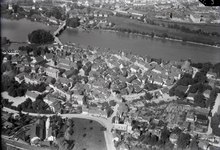
 Aerial view: Rheinfelden (Aargau) on the left and Rheinfelden (Baden) on the right of the Rhine |
|
| Location of the municipality | |
  |
|
Rheinfelden ( Swiss German Rhyfaele [ Hauptiːˌfældə ]) is a small town and municipality in Switzerland and the capital of the Rheinfelden district in the canton of Aargau . The regional center of the Fricktal region is located on the Upper Rhine on the border with Germany , on the eastern edge of the Basel conurbation . With a little more than 13,000 inhabitants, Rheinfelden is the sixth largest city in Aargau. It is economically and socially closely linked to the city of Rheinfelden (Baden) on the opposite side of the Rhine, which was built at the end of the 19th century and has had the same name since 1922.
Stein Castle , the seat of the Counts of Rheinfelden, was built on a river island in the 10th century . A fortified city developed from a market town on the south bank of the Rhine in the course of the 12th century, during the rule of the Zähringers . The castle was the main residence of the Habsburgs for several decades , while the city was imperial free from 1218 to 1330 and from 1415 until it finally came under Habsburg or Austrian rule in 1439. Rheinfelden was directly affected by the effects of the Thirty Years' War and was occupied by Swedish and French troops from 1638 to 1650 after the Battle of Rheinfelden . Conquered by France in 1797, the city became part of Switzerland in 1802 and has been the district capital of the canton of Aargau since 1803. Since the 1970s, the population grew rapidly when the city became part of the Basel agglomeration .
Important economic factors are the production of beer (the Feldschlösschen brewery located here is the largest in Switzerland) and the extraction of extensive salt deposits by the Riburg saltworks . From the middle of the 19th century onwards, the brine produced during salt mining enabled Rheinfeld to develop into a health resort that gradually adapted to the requirements of modern tourism and is now mainly geared towards therapy and rehabilitation.
geography
Rheinfelden is 17 kilometers east of Basel , in the north-western corner of the canton of Aargau on the border with Germany . The urban area extends along the left bank of the High Rhine over a length of around nine kilometers, with an average width of around two and a half kilometers. The Inseli , an island of shell limestone rocks around 150 meters long and 47 meters from the left bank, shaped the development of the city . This also serves as a natural (intermediate) bridgehead for the Rhine crossing. A steep-walled ditch runs in the river bed, a tectonic plate boundary at the extreme southeastern edge of the Upper Rhine Plain . The 700 meter long ditch begins at a rapids known as Höllhaken and ends at the Rhine bridge in St. Anna Loch , a 32 meter deep basin with dangerous eddies. The Rhine is navigable from Rheinfelden to the North Sea .
Right or left bank of the foothills to leave the southern Black Forest belonging Dinkel Berg and the Jura plateau one with powerful gravel deposits covered valley floor free of a Rheinfeld is called. On the Swiss side, it is about one kilometer wide on the western edge of the city, expands in an easterly direction and reaches a width of over three kilometers at the terminal moraine of Möhlin . The old town of Rheinfeld is located on a rock terrace that belongs to the same formation as the Inseli. In the west, the terrace slopes down to the Heimendeckenloch . This gorge, which was largely covered in 1903 and was once up to 14 meters deep, formed a bed of the Rhine in prehistoric times, through which the Magdenerbach , coming from the south, later flowed. Since the city was founded, the stream has flowed east past the old town into the Rhine. Almost its entire width, the old town is traversed by a pronounced slope edge, its easternmost part is leveled out by artificial filling. Another terrace, the Kapuzinerberg, rises south of the old town and west of the Magdenerbach. This merges into a foothill of the Table Jura, the mountain ( 419 m above sea level ). The Steppberg ( 373 m above sea level ) rises to the east of the stream . The highest point is at 419 meters on the mountain , the lowest at 270 meters on the banks of the Rhine.
The area of the municipality is 1602 hectares ; of which 797 hectares are forested and 406 hectares are built over. Neighboring communities in Switzerland are Kaiseraugst in the west, Olsberg in the southwest, Magden in the south and Möhlin in the east. In the north Rheinfelden borders on the German sister city Rheinfelden (Baden) , in the northeast on Schwörstadt .
Rheinfeld's “Inventory of Culture and Nature” from 2008 includes 90 protected cultural and natural objects outside the settlement area. This includes u. a. 15 hedges , ten diverse landscape areas, eight ponds , six old wood islands and six wetlands as well as a cave. In addition, 19 sites of the reptile species sand lizard , wall lizard and slow worm are shown .
climate
Rheinfelden lies in the temperate climate zone . Due to various factors, the climate is relatively mild. The Basel region is one of the warmest north of the Alps and has up to 40 more sunny days than the Swiss plateau . A regional weather phenomenon is the Möhlin-Jet , a wind that ensures, especially in winter, that a closed blanket of fog rarely forms in the Rhine plain.
On the Kapuzinerberg, at an altitude of 300 m above sea level. M., is a measuring station of the Federal Office for Meteorology and Climatology . The annual mean temperature there is 8.9 ° C. The coldest month is January with an average of −0.1 ° C, the warmest is July with 18.1 ° C. There are an average of 8.8 hot days above 30 ° C and 13.0 ice days below 0 ° C. The annual rainfall is around 974 mm, with higher amounts being measured, especially in the three summer months due to the convection , than during the other seasons. The maximum is reached in August with 102 mm, the minimum in October with 66 mm.
| Rheinfelden | ||||||||||||||||||||||||||||||||||||||||||||||||
|---|---|---|---|---|---|---|---|---|---|---|---|---|---|---|---|---|---|---|---|---|---|---|---|---|---|---|---|---|---|---|---|---|---|---|---|---|---|---|---|---|---|---|---|---|---|---|---|---|
| Climate diagram | ||||||||||||||||||||||||||||||||||||||||||||||||
| ||||||||||||||||||||||||||||||||||||||||||||||||
|
Average monthly temperatures and rainfall for Rheinfelden
Source:
|
||||||||||||||||||||||||||||||||||||||||||||||||||||||||||||||||||||||||||||||||||||||||||||||||||||||||||||||||||||||||||||||||||||||||||||||||||||||
history
Before the city was founded
During the Mesolithic period about 10,000 years ago, people lived on the Hermitage , a Nagelfluh hillside near today's A3 motorway . There were 1,930 during construction works an open air site with remains of hearths and animal bones and 17 artifacts from limestone and flint to light.

A few kilometers west of Rheinfelden was built around the year 44 BC. Chr. Augusta Raurica ( Augst ), the oldest Roman city on Swiss soil. A Roman road ran through the later urban area of Rheinfeldens eastwards over the Bözbergpass to Vindonissa ( Windisch ). A crossroads in the area of what is now the “Drei Könige” inn was presumably the location of a customs post, which is called Caistena Cassangita in a directory compiled before 537 and appears in the 8th century by the geographer of Ravenna . There a path branched off into Magdenertal, another led to a ferry on the Rhine (with a towpath on the opposite bank to overcome the rapids). In 2001, two Roman aqueducts leading to Augusta Raurica were exposed, in the same year the remains of a fortified system with a granary from the 4th century in Augarten (the only find of a larger wooden fortification from Roman times in Switzerland), and in 2013 a brick kiln. A manor was built around 260 on the Rheinfeld plain , near Görbelhof . At least two buildings are known, a house and a workshop. The manor was given up around 350. In the Reitrichgraben, in Heimenholz and probably on Inseli there were Roman watchtowers in the 4th century, which formed part of the Rhine Limes .

In the 6th and 7th century, settled Alemanni on. The Rifelt was first mentioned in a document in 851 . This designation comes from the Old High German (ze) Rhinfëldun and means "near the fields on the Rhine", whereby a field name rather than an actual place name should be assumed. The Aargau seems to have been incorporated into the expanding Burgundian Empire after 900. Rudolf II. Succeeded but 919 in the Battle of Winterthur to stop further expansion and 920 recognition as Swabian Duke by King Henry I find. The Augstgau , the area in the acute angle between the Rhine and Aare , formed the northeasternmost tip of the Kingdom of Burgundy . In 1006 Heinrich II. , King of Eastern France and later Roman-German Emperor, received the area from the last Burgundian King , Rudolf III. given.
Also in the 10th century, a noble family settled on the rock terrace, who had family ties to both the Burgundian royal family and the Salians . The counts of Rheinfelden, retrospectively named, owned goods on both sides of the Rhine and took on an important mediating role during this time of political upheaval, which gave them great influence. They built Stein Castle on Inseli, and the "old castle" near the south bank, where a settlement began to develop. The best-known representative of the family is Rudolf von Rheinfelden , from 1057 Duke of Swabia and from 1077 anti -king of the Roman-German Empire. His death in the battle of Hohenmölsen in 1080 prevented Rheinfelder from becoming a royal center of power.
Zahringian rule and imperial city
Rudolf's son, Berchtold von Rheinfelden, died in 1090 without male offspring. Berthold II von Zähringen , who was married to Rudolf's daughter Agnes von Rheinfelden , became his inheritance. The settlement near the "old castle" had meanwhile grown into a market town and around 1100 the first hall church was built. A document reports two visits by the crusade preacher Bernhard von Clairvaux in December 1146 and names the castle and a church. The Zähringer continuously expanded the settlement into a town in the following decades. The Rhine Bridge was built in the second half of the 12th century, and Heinricus de Ponte ("Heinrich von der Brücke") is mentioned in a document from 1198 . The Rheinfelder Brücke is therefore the oldest between Constance and Strasbourg (and therefore also older than the Mittlere Brücke in Basel ). A city wall was also built around this time. Rheinfelden had an important strategic importance as a link between the Zähringian possessions in Breisgau and those in the Bern area . It is not known when exactly Rheinfelden received city rights , as numerous documents were destroyed in the fire in the town hall in 1531 . This should have happened before 1212 (mention of a mayor ), making Rheinfelden the oldest town in Aargau. The oldest surviving document created in Rheinfelden itself is the town charter, written down in 1290.
With the death of Berthold V in 1218, the family of the Zähringers and Emperor Friedrich II immediately secured Stein Castle for the empire. In the same year he gave Rheinfelden the status of an imperial city and thus preceded Count Egino IV of Urach , who wanted to bring the city into his possession. The Rheinfelder were allowed to regulate their internal affairs freely, enter into alliances and wage war. After the decline of the Staufer , during the interregnum , ruled from 1254 temporarily bishops of Basel until 1273, the new Roman-German King Rudolf I of the House of Habsburg , the imperial immediacy restored. He assured the city of blood jurisdiction and granted its citizens the right to own fiefdoms . For several decades, Stein Castle was the main residence of the Habsburgs and the place where imperial regalia were kept , and in 1283 Rudolf I issued the Rheinfeld House Rules there . In 1330 the city also came under the Habsburg rule when Emperor Ludwig IV of the Wittelsbach family pledged it to Duke Otto the Happy .
The administration of the city was initially in the hands of ministerials . In 1331 three guilds were admitted (later called Zunft zum Bock, Kaufleutenzunft and Zunft zum Gilgenberg). They gradually ousted the nobles from the governing bodies and from the middle of the 15th century elected all council members themselves. At the top was the «Small Council», headed by the mayor, with 15 members and extensive powers. This was elected from the ranks of the 33-member «Grand Council», which exercised control functions. The civil parish had little influence, with the exception of the city court, which they were allowed to occupy half. The last noble mayor was Rudolf von Schönau in 1531 .
Habsburgs and Burgundians

As one of the four forest cities , Rheinfelden repeatedly set contingents against the Confederates in the Habsburg Wars . In 1405 , Duke Friedrich IV, who was in dire financial straits, pledged the castle to Jakob Zibol , a wealthy citizen of Basel. The Rheinfelder feared a military occupation by Basel, declared a feud in October 1409 and occupied the castle. On November 18, 1409 they undertook a cattle raid in Waldenburgertal . On their return they were ambushed; the battle near Magden claimed 80 dead on the Rhine fields and 26 on the Basel side. In 1412 the cities made peace. Three years later, Duke Friedrich IV fell out of favor at the Council of Constance after he had antipope John XXIII. had helped escape. While the Confederates conquered large parts of Aargau in the name of the empire, King Sigismund declared Rheinfelden an imperial city again on June 17, 1415. In 1418 he merged the castle and town into one rule. The renewed imperial freedom was short-lived: The Roman-German King Albrecht II placed the city back under Habsburg sovereignty on July 13, 1439.
In the 1440s Rheinfelden was involved in the Old Zurich War . Since the Habsburgs could not offer sufficient protection, the city entered into a ten-year alliance with Basel on June 9, 1445, which in turn provoked hostile reactions from nobles loyal to the Habsburg castle. Basel troops and allied Bernese and Solothurners began the siege of Stein Castle in August. After four weeks the occupation surrendered, whereupon the island castle was looted and razed in February 1446 . On October 23, 1448, aristocratic warriors disguised as pilgrims (under the command of Hans von Rechberg ) took the city in a flash and plundered it. They then undertook several raids in the area from Rheinfelden, which provoked Basel to retaliate. The alliance between the two cities broke up and the badly affected Rheinfelden saw no other way out than to submit to the Habsburgs on June 8, 1449. In 1467, Duke Siegmund Rheinfelden temporarily pledged it to Basel, which provoked violent protests. In the following year, federal mercenaries devastated the region on the Upper Rhine in the Waldshut War . To finance the compensation agreed in the peace treaty, Siegmund pledged the entire Austrian foreland for 50,000 guilders to the Burgundian Duke Charles the Bold . The reckless action of Bailiff Peter von Hagenbach united the former warring parties against the Burgundian rule and was one of the triggers of the Burgundian Wars . It is possible that a Rheinfeld contingent was involved in the battle of Héricourt in 1474 . With the death of Charles in 1477, the Habsburgs took possession of the pledged territories again.
During the Swabian War of 1499, Austrian troops used Rheinfelden as a base of operations. In 1501, Basel's accession to the Swiss Confederation resulted in a clear political and legal separation between the two cities - a development that intensified with the Basel Reformation in 1529 . During the Rappen War of 1612, insurgent farmers tried in vain to besiege the city, which was emphatically neutral, but devastated the surrounding area. Rheinfelden was represented in the Breisgau estates since the time of the Burgundian rule ; In addition, the city was the administrative seat (but not part of) the Rheinfelden cameraman .
In the field of tension between the great powers

Rheinfelden was directly affected by the events of the Thirty Years' War , due to the Camino de Suizos military road running along the right bank of the Rhine and its role as an exposed outpost of Austria. In September 1632, Swedish troops devastated the area around the city. They returned the following year under the command of Rheingraf Otto Ludwig and occupied Rheinfelden on July 15, 1633 after a ten-day siege. Spanish troops under Duke de Feria drove out the Swedes and handed Rheinfelden back to Austria on October 16, which reinforced the occupation. On March 27, 1634, the Swedes closed another siege ring. After 21 weeks, Franz von Mercy , in view of the lack of ammunition and provisions, had no choice but to surrender on August 19. The Swedes left the ransacked city on September 14th, set fire to numerous buildings and destroyed the bridge and part of the fortifications. The southern village of Höflingen , part of Rheinfelden, was so badly devastated that it was never rebuilt.
_p_019.JPG)
The double battle of Rheinfelden followed four years later . Shortly after the capture of Säckingen , Swedish Protestant troops under the command of Bernhard von Sachsen-Weimar began the siege on February 9, 1638. On February 28, the numerically superior imperial Bavarian troops under Johann von Werth and Federigo Savelli succeeded in routing the besiegers. However, Bernhard inflicted a heavy defeat on them in the second armed forces on March 3, after he and his units had unexpectedly reappeared on the battlefield on the right bank of the Rhine. Savelli and von Werth were captured and the city surrendered on March 25th. The Swedes held Rheinfelden until 1647 and handed the city over to the French, who finally withdrew in October 1650.
After the makeshift restoration of the city walls, Rheinfelden was drawn into the Dutch War . From July 6 to 18, 1678, French troops under François de Créquy continuously bombarded the city, but the capture failed. Between 1684 and 1692 the Austrians built an artillery fortress on the island. A military neutralization of the Rhine border was supposed to offer further protection: In 1691 the confederates undertook, with the consent of France, to occupy the Fricktal on the left bank of the Rhine at the imperial expense . Rheinfelden was spared the Palatinate War of Succession and the War of Spanish Succession . Due to internal disputes, the Confederates no longer maintained the neutralization from 1735. In September 1744, during the War of the Austrian Succession, a French army under Marshal Belle-Isle advanced to the Upper Rhine and Rheinfelden capitulated after a brief siege. Three months later, the French blew up the fortress and bastions. Austria, which came into possession of Rheinfelder again in 1745, repaired the city walls, but decided not to rebuild the fortress.
As early as 1695, Emperor Leopold I was considering pledging the Fricktal to Solothurn. The unanimous rejection of the population in 1739 was met by Charles VI. proposed pledge to Bern or Basel. Ten years later, Maria Theresia turned down a Basel purchase offer. The government reforms of the Empress initiated a modest recovery from 1750. The new city constitution of 1756 reduced the city authorities to an "inner council" with the mayor, city clerk and four assessors, which severely restricted the influence of the guilds. The government intervened directly in economic and social life with numerous decrees. The centralistic tendencies intensified from 1780 under their successor Joseph II. Despite all reform efforts, the Fricktal was considered a prime example of an impoverished area: There were no manufactories or home industries and many Rheinfelder were indebted to Basel citizens. In addition, the burden of high military spending prevented investments. In 1779 the city had to build barracks to house a regiment at its own expense.
Belonging to Switzerland


The ideas of the French Revolution found little acceptance, and only a few agitators were active. Through the enlightened absolutism of Maria Theresa and Joseph, which had made some social improvements possible, there was a great loyalty of the population to the rulers. In addition, refugees who portrayed the events in France negatively found refuge in Rheinfelden. French troops advanced across the Rhine during the First Coalition War and occupied the city on June 17, 1796, but were driven out on October 24. A secret additional article of the peace of Campo Formio , which was concluded in October 1797, assured France of all areas on the left bank of the Rhine. The Fricktal was now a French protectorate, but the Austrian officials initially stayed on site. When the Second Coalition War broke out two years later , the French occupied Rheinfelden on March 1, 1799 without a fight. The population had to endure billeting, requisitions and protection money.
The Peace of Lunéville in February 1801 confirmed the existing status. Napoleon Bonaparte planned to annex the Fricktal to the Helvetic Republic . A possible merger with the canton of Basel met with clear resistance from the population. Finally, Sebastian Fahrländer proclaimed the canton of Fricktal in February 1802 with French tolerance . Its main town was initially Laufenburg , after Fahrländer's dismissal in September of the same year Rheinfelden. With the adoption of the mediation act , the Fricktal became part of the Swiss Confederation on February 19, 1803, and Rheinfelden became the district capital in the new canton of Aargau . The Peace of Pressburg in December 1805 ended the existence of Front Austria and from then on the Rhine formed the border with the Grand Duchy of Baden . The little significant part of the city area on the right bank of the Rhine, directly at the northern bridgehead, was lost with the Reichsdeputationshauptschluss . From December 1813 to June 1814, several thousand Austrian and Russian soldiers had to be quartered and fed, which was another great burden. The population got used to the changed rulership only slowly: In June 1814 they gave the Emperor Franz I a triumphant reception.
The town, which continues to be dominated by small farmers and businesses, stagnated during the first decades of its membership in Switzerland, not least because of the new customs border with Baden. In contrast to the rest of Aargau, the replacement of the tithe took place relatively quickly: under the leadership of the largest landowners, the necessary funds could be obtained as early as 1818 to buy the tithe to the canons of St. Martin and Olsberg . The medieval curtain wall had lost its protective function. In the course of the 19th century several towers were torn down, the last rubble of the destroyed island fortress was removed and the wall was broken through in numerous places.
During the Baden Revolution of 1848/49, Rheinfelden served as a retreat for several prominent insurgents, including Theodor Mögling and Fidel Hollinger . After the decisive battle near Waghäusel , over 1,500 revolutionaries fled over the Rheinfeld Bridge to Switzerland in June 1849. After initially threatening to storm the bridge, the Swiss military persuaded them, after negotiations, to cross the border unarmed.
Industrialization and tourism

The industrialization began relatively late. In May 1844 Theophil L'Orsa came across high-yield salt deposits while drilling exploratory bores east of the city , and one month later he was awarded a production license. This prompted his competitor Johann Urban Kym to drill for further salt deposits near Riburg (directly on the municipality border with Möhlin ). Kym also received a concession and the Riburg salt works went into operation in early 1848. In 1873, the salt mines in Rheinfelden and closed Kaiseraugst to the Swiss Saltworks together, which in turn merged in 1909 with the Saline Schweizerhalle to today's Swiss salt works . The older of the Rheinfeld salt pans was shut down in 1942.
With the arrival of the Dillemann company in 1849, Rheinfelden developed into a center for cigar production . In total, there were a dozen companies in this branch, most of which were closed again after a short time. The production of beer is still of great importance today . In 1799 Franz Joseph Dietschy founded the Salmenbräu brewery , which introduced industrial production methods in the 1850s. Theophil Roniger and Matthias Wüthrich founded the Feldschlösschen brewery in 1876 , which became the largest in Switzerland.

Almost simultaneously with the mining of the salt deposits, the use of the brine for healing purposes also began, when an innkeeper opened a spa in 1845 and others followed his example. In 1864, the cantonal government approved the construction of a poor bathing facility in order to enable less well-off sections of the population to take a spa stay. In order to promote bathing tourism, a spa association was founded in 1866, which over the years had an increasing influence on community politics and implemented numerous improvements to the infrastructure. The first touristic heyday began in 1882 with the opening of the luxurious Grand Hôtel des Salines . Several other hotels were built or converted to meet the high demands of international guests. Rheinfelden was one of the most famous spa resorts in Europe at the turn of the century and was particularly popular with wealthy French and Russian tourists. In 1897 a state-sponsored sanatorium was opened .
When the first section of the Hochrheinbahn between Basel Badischer Bahnhof and Bad Säckingen opened on February 4, 1856 , Rheinfelden was indirectly connected to the railway network: on the German side, the station at Rheinfelden was built not far from the Rhine bridge . In 1869, a committee was formed to build the Bözberg route from Basel to Brugg , and the city signed bonds totaling 500,000 francs. The joint venture between Centralbahn and Nordostbahn opened on August 2nd, 1875 after a four-year construction period. After two decades of planning, the Grand Duchy of Baden and the Canton of Aargau granted the concession in 1894 to build a power plant that was immense for the time. A consortium led by AEG began in 1895 with the construction of the Rheinfelden hydropower plant , the first large run-of-river power plant in Europe. Electricity production began in 1898, and work was completed in June 1899. The city tried to negotiate favorable terms for its own electrical energy requirements with the operator KWR (Krafttransmission works Rheinfelden). Only after the court had the power to pass through did the KWR give in and set up part of the city street lighting free of charge. This was put into operation in February 1899 and replaced the gas lighting that had existed since 1874.
Borderline in the world wars
The power plant attracted several energy-intensive industrial companies on the German side. Within a few years the working-class town of Rheinfelden (Baden) came into being , which was in complete contrast to the glamorous health resort on the south bank. Close social and economic relationships developed between the sister cities. During the First World War , the number of cross-border commuters to Germany remained high, but fell rapidly due to the hyperinflation of 1923 and continued to decline afterwards. The industry in Rheinfelden, Switzerland, proved to be relatively crisis-proof due to its stable structure, but new company foundations were rare. Due to the war, the international spa guests largely stayed away; domestic tourists took their place. The classic spa stay of several weeks fell out of fashion, so that Rheinfelden increasingly relied on conferences, congresses and other events.
After the seizure of power of the Nazi party in Germany, the commuters were increasingly harassed and the Nazis also tried to spread their ideology on the Swiss side. In response to this, an underground network was formed along the border that brought the politically persecuted to Switzerland and smuggled propaganda material across the border from there. At the beginning of the Second World War , the number of tourists collapsed as the Swiss Army claimed a large part of the accommodation for itself. Rheinfelden was affected by the usual measures such as blackout and rationing. When an attack by the Wehrmacht on Switzerland could not be ruled out in May 1940 , many residents temporarily fled inland. As part of the cultivation battle , large open spaces were converted into fields, and part of the forest was cleared. Numerous forced laborers managed to flee to Switzerland from 1941 onwards. Between April 21 and 25, 1945 alone, shortly before the French troops marched in, over 3,000 refugees streamed across the bridge. The French then sealed off the border hermetically and did not reopen it until 1948.
Economic growth, temporary decline in tourism
_02.jpg)
The 1950s, and especially the 1960s, were marked by unprecedented economic growth. The Basel chemical industry relocated its production facilities to the lower Fricktal and Rheinfelden became the undisputed regional center within the agglomeration of Basel. This development was reinforced by the construction of the A3 motorway, which reached the city in June 1966 and Frick eight years later . To counter the acute shortage of living space, Ciba-Geigy had the Augarten housing estate built between 1971 and 1976 for 3,000 residents. Meanwhile, the importance of the health resort continued to decline, which was particularly evident in 1963 with the closure of the Grand Hotel. The downward trend was reversed in the 1970s by realigning Rheinfeld into a medical-therapeutic health center and expanding the leisure and wellness facilities. In 1973 the then largest saltwater indoor swimming pool in Switzerland was opened and from the 1980s the traditional saltwater pools were transformed into specialized clinics.
Cross-border local political relations were resumed in 1954, but were immediately exposed to stress, as increasing fluorine emissions from aluminum Rheinfelden caused damage on the Swiss side. The company shied away from the high investments in absorption systems and the German authorities did not want to take action for fear of job losses, so it came to the "fluorine war": On July 22, 1958, thousands of demonstrators moved from Möhlin to the Rheinfelder Brücke and demanded the immediate closure of all non-renovated stoves. There were further protests in the 1970s and 1980s against chlorine and dioxin emissions. From 1971 on there was bitter resistance to the construction of the Kaiseraugst nuclear power plant immediately west of the city limits. In particular, the Rheinfelder feared massive negative effects on the spa business. The project was finally abandoned in 1988. In the same year, the hydropower plant's concession was only granted on condition that it was replaced by a new, more powerful power plant. The new hydropower plant in Rheinfelden was built from 2003 in a seven-year construction period, while the old power plant was demolished in 2011 after protracted debates about its possible status as an industrial monument.
Religions

Rheinfelden initially belonged to the parish of Magden until the Zähringers removed the city and the Martinskirche, which had existed since the early 11th century, from the parish. In 1228 the canon monastery of St. Martin was founded, which was under Habsburg protection from 1330. Since 1212, the Johanniterkommende Rheinfelden existed a little outside the city . Like the Canons, the Johanniter enjoyed tax exemption and were not subject to the municipal legal system. During the raid of 1448 the commander was destroyed and then rebuilt within the city walls. From 1349 to 1510 there was also a community of Beguines .

When Johann Eberlin von Günzburg spread Reformation ideas in the summer of 1523 , his explanations met with great interest. During the Peasants' War of 1524/25, the city played a mediating role between the Austrian rulers and the rebellious landscape. Although Rheinfelden remained Catholic because of Austria's established position of power, the clergy who worked here were remarkably tolerant of reformatory innovations for several decades. Nevertheless, the small Protestant minority was either re-Catholicized or over time moved to Basel. To promote universal piety, the Rheinfelden Capuchin monastery was founded in 1596 .
The Coming Party could never really recover from the devastation of the Thirty Years' War and lost influence. The establishment of the canton of Aargau accelerated the decline of religious institutions. The Capuchin monastery was secularized in 1804 , and so did the Coming in 1806. As a result of the Reichsdeputationshauptschluss, the Canon Monastery lost most of its property and got into a serious financial emergency, from which it could not find its way out until its dissolution in 1870. Rheinfelden was still predominantly Catholic in the first half of the 19th century, but the denominational disputes, which repeatedly caused turmoil in other Catholic areas of Aargau, met with far less echo here. The Josephinism of the late Austrian era had a lasting effect, so that the population was more open to government intervention in religious matters. The city was generally considered a stronghold of Catholic liberalism.
Reformed people were allowed to settle freely from 1814. In 1854 they were given their own restaurant, the Margaret Chapel of the former infirmary. The Reformed Church in Rheinfelden was built in 1894/95 . The dogma of papal infallibility announced at the First Vatican Council met with unanimous rejection in Rheinfelden. In 1872 an "Association of Liberal Catholics" was formed, which represented most of the parishioners. In November 1873, the Roman Catholic parish almost completely converted to the Christian Catholic movement, and on September 13, 1876, the first Christian Catholic bishop in Switzerland was consecrated in St. Nine years after the split, the remaining Roman Catholics were given their own house of worship again, the Josefskirche , which was rebuilt in 1949/50. Over the decades, the proportion of Christian Catholics decreased steadily, mainly due to the heavy immigration from neighboring Roman Catholic and Reformed areas.
The immigration of Muslims began in the 1960s, initially mainly from Turkey , and from the 1990s also from the Balkans . The Islamic cultural association Merkez Camii operates a small mosque with around 300 members. In addition, the Alperenler Mosque has existed in Rheinfelden in Baden since 1996 .
Cityscape and architecture
Old town

The semicircular old town lies on the south bank of the Rhine and is classified in the inventory of places worthy of protection in Switzerland as a place of national importance. Essentially, the structure corresponds to the state of the 17th and 18th centuries, with buildings in the late Gothic , Baroque and early Classicist styles. The wall ring of the Rheinfeld city fortifications was once around 730 meters long. Of this, 330 meters have been left since the end of the 19th century, mainly on the east side along the Magdenerbach , which served as a natural city moat. Four city gates with towers have been preserved: the knife tower on the northeast corner directly on the banks of the Rhine (built before the 15th century), the copper gate tower in the east (1359/60), the Obertorturm in the southeast (1329/30) and the water tower in the south (early 13th century). A special feature of the Obertorturm is the tower clock, which has always strikes seven minutes too early; Since the gates were once locked in the evening, the farmers working in the fields in front of the gate had enough time to return to the city. Stein Castle on Inseli was also part of the city fortifications ; Neither of it nor of the artillery fortress built later in the 1680s has survived.

The main axis of the old town is Marktgasse, which runs eastward from the Old Rhine Bridge and runs parallel to the Rhine. The closed, continuous eaves-free rows of houses combine to form a uniform overall picture, whereby the height and position of the roof ridges differ from each other due to the different house depths. The individual buildings are almost without exception three or four storeys high. Also accentuated by a square-like extension, the town hall on the north side is the most striking building on Marktgasse. The four-wing complex, which is surmounted by a seven-story tower, dates back to the 14th century. A 15-part cycle of glass paintings in the council chamber made in the 1530s is particularly valuable from an art-historical point of view. Other outstanding buildings on Marktgasse are the Haus zum Drachen , the Haus zum Meerhafen , the Haus zur Sonne and the Haus zum Salmen . At the eastern end of Marktgasse is the Albrechtsplatz with the Albrechtsbrunnen . To the north of it, on Johannitergasse, you will find the building complex of the former Johanniterkommende , which was built in the 1450s and which also includes the Johanniterkapelle .
.jpg)
The landmark and center of the old town is the Christian Catholic town church of St. Martin . The building between the church square and the main guard square dates back to the 11th century. The church building that exists today with its Gothic exterior and baroque furnishings dates from the second half of the 14th century and was subsequently expanded and rebuilt several times, most recently in the 1770s. Representative buildings in the vicinity of the city church are the Spyserhaus , the Haus zum Lustgarten , the Schönauerhof and the Hugenfeldschule . The latter two were noble residences and are located on the area of the former "old castle" of the Counts of Rheinfelden. On the southern edge of the old town is the former Capuchin monastery , which was structurally heavily modified in the early 19th century; The outer shell of the nave has been preserved. Next to the monastery is the Commandantenhaus , the former residence of the Austrian garrison commander. The townscape in the southeastern part of the old town are the Gasthaus zum Ochsen and the Gasthof zum Goldenen Adler .
Remaining city area

To the east of the old town is the city park. The south-western part of the church near the Gottesackerkapelle , built in 1740, was used as a cemetery until the 1920s; in the north-eastern corner there is a former brine drilling tower from the Riburg saltworks (1908) as an industrial historical monument. The city park has existed since 1969, when the public sector acquired the western part of the Grand Hôtel des Salines park and had it redesigned. The hotel complex on the banks of the Rhine consists of three parts, with the neo-Gothic west wing in particular reminding of the heyday of beach tourism. Another reminder of this era is the Kurbrunnenanlage was immediately west of the old town, the social center of the spa life.
The Kapuzinerberg plateau south of the train station has been a preferred residential area since the early 20th century. From this time, individual villas in the style of historicism and new building have been preserved. The Feldschlösschen brewery area extends on the southwestern edge of the high plateau . The core area of the extensive complex, which was built between 1892 and 1908, is dominated by medieval and Gothic forms; younger buildings follow neoclassicism and the new objectivity , but still correspond in the main to the castle style. Through its consistent use until the 1990s, the "Brewery Castle" developed into one of the most imposing and important industrial monuments in Switzerland.
The city of Rheinfelden was awarded the Wakker Prize 2016 on January 19, 2016 .
coat of arms

The blazon of the municipal coat of arms reads: "Five times divided by yellow and red, the red places are each occupied by three six-pointed yellow stars."
The Rheinfeld city coat of arms is based on the coat of arms of the Counts of Rheinfelden from the 10th century and first appeared on the Schultheiss seal in 1236. At that time it consisted of three yellow and three red crossbars. Later the stars were added to the red bar. From 1254 there were six, from 1533 seven and from 1599 nine stars. Each star symbolizes a virtue of the city dwellers. It is about honesty, honor, faith, freedom, righteousness, activity, contempt for death, loyalty and altruism. There were numerous variants side by side and for a long time it was unclear which color was on top. In 1952 the city council set red, but then changed its mind in 1985. This decision is disadvantageous insofar as the stars in the lowest field are compressed and therefore appear disproportionately. The district coat of arms, however, remained unchanged and begins at the top with red.
At the local citizens' assembly in 1944, Ernst Grell proposed that, as a symbolic symbol for the stars in the coat of arms, "nine oaks should be endured as inviolable landmarks in the forest or left for all future". The then forest manager Fritz Wunderlin accepted the application and designated a total of nine oaks in all parts of the forest. They were marked with a red star and a consecutive number. The numbers 1, 4 and 7 had to be replaced in the meantime, the others are still the heraldic trees selected in 1944.
population
The population developed as follows:
| year | 1650 | 1788 | 1850 | 1900 | 1930 | 1950 | 1960 | 1970 | 1980 | 1990 | 2000 | 2010 |
| Residents | 900 | 1226 | 1910 | 3349 | 3827 | 4550 | 5197 | 6866 | 9456 | 9761 | 10,673 | 11,960 |
On December 31, 2019, 13,524 people lived in Rheinfelden, the proportion of foreigners was 32.5% and was thus well above the cantonal average of 23.8%. According to the census of December 5, 2000, of the 2,736 inhabitants with foreign citizenship at the time, 19.8% came from Italy , 14.8% from Germany , 12.9% each from the Federal Republic of Yugoslavia and Turkey , 4.7% from Portugal , 4.5% from Macedonia , 3.7% each from Bosnia and Herzegovina and Spain , 2.1% from Austria and 1.6% from Great Britain . Of the respondents, 82.9% German as their primary language, 3.8% Italian , 2.0% Serbo-Croatian , the 1.9% Albanian and Turkish , 1.3% French , the 1.1% English and Portuguese as well 0.8% Spanish . In the 2015 census, 27.5% described themselves as Roman Catholic , 21.8% as Reformed and 1.7% as Christian Catholic ; 49.0% were non-denominational or of other faiths.
Politics and law
.JPG)
The political municipality (called a community of residents in the canton of Aargau) performs all municipal tasks that have not been declared to be the sphere of activity of another type of municipality (for example the parishes of the regional churches ) by higher-level law . The assembly of the electorate, the twice yearly parish meeting , exercises the legislative power. Rheinfelden is the largest municipality in the canton that does not have a residents' council . Its introduction was rejected three times in referendums (1974, 1998 and 2014).
The executing authority is the five-member city council . He is elected by the people in the majority procedure, his term of office is four years. The city council leads and represents the local community. To this end, it implements the resolutions of the municipal assembly and the tasks assigned to it by the canton. The meetings take place in the town hall . As head of the executive practicing Stadtammann from its activities in full office, the other councilors in the next office.
The five city councils for the 2018-2021 term are:
- Franco Mazzi ( FDP ), mayor
- Walter Jucker ( SVP ), Vice-Captain
- Dominik Burkhard ( GLP )
- Hans Gloor (independent)
- Susanna Schlittler (FDP)
The local citizens' community includes those residents who are citizens of Rheinfelden. Its main task is the management of the local citizens' property, the origin of which lies in the civil estates that were taken over from the time of the Ancien Régime. For example, the local community is in possession of all forest areas in the urban area; In addition, there is income from the sale of gravel and the rental of various properties. The legislature is the local citizens' assembly, the executive is the city council of the municipality (which also includes non-local citizens).
The Rheinfelden District Court is the first instance responsible for legal disputes . Rheinfelden is the seat of the Friedensrichterkreis XIV, which covers the whole district. In addition, since 2011 the city has been the seat of the regional public prosecutor's office for the Rheinfelden and Laufenburg districts .
In the Swiss parliamentary elections 2019, the share of the vote in Rheinfelden was: SP 22.2%, SVP 21.0%, FDP 15.3%, glp 12.1%, Greens 11.5%, CVP 8.3%, BDP 2, 6%, team 65+ 2.2%, EVP 2.0%, EDU 1.3%.
economy
According to the corporate structure statistics (STATENT) collected in 2015, there are around 7,700 jobs in Rheinfelden. Of this, 0.2% is in agriculture, 17.0% in industry and 82.8% in the service sector. As the center of a sub-agglomeration within the Basel metropolitan region , Rheinfelden has strong commuter flows . The ratio of inbound and outbound commuters is - in contrast to numerous municipalities in the region with a clearly identifiable orientation of the working population towards the centers - significantly more balanced. According to the 2000 census, 2,807 people commuted here, while 3,453 people were employed elsewhere (mainly in Basel and the surrounding area).
Industry

Rheinfelden is particularly known as the location of the largest brewery in the country. It belongs to the Feldschlösschen Getränke company , the largest beverage retailer in Switzerland. Around a third of Switzerland's total beer production is concentrated here. Feldschlösschen has been a subsidiary of the Danish Carlsberg Group since 2000 .

The Saline Riburg of the Schweizer Salinen company is located on the municipal border with Möhlin, around two kilometers east of the old town and separated from the rest of Rheinfeld's settlement area by a wide forest belt , where de-icing and industrial salt in particular is produced. The hourly production volume is up to 50 tons. The company's landmarks are two domed warehouses called Saldome . The two largest domed buildings in Switzerland can store 80,000 and 100,000 tonnes of salt, respectively. Another important company is Josef Meyer Rail AG, which specializes in the repair of freight wagons and the manufacture of welded assemblies. The new Rheinfelden hydropower plant, which went into operation in 2010, generates 600 million kilowatt hours of electrical energy annually with an installed capacity of 100 MW ; The operator is Energiedienst Holding .
At the turn of the millennium, Rheinfeld's industry experienced a significant structural change. The Salmenbräu brewery , which was incorporated into Sibra-Holding (later Cardinal ) in 1971 , was taken over by Feldschlösschen in 1991. This initially continued to use the Salmenbräu plant to produce non-alcoholic beer until the brewery was finally shut down in 2002. Three years later, the stocking manufacturer Chiarello , which was founded in 1954, ceased production and in 2008 the last representative of the cigar industry, Wuhrmann & Co., which had existed since 1876, disappeared . The rapidly growing service sector largely offset the loss of industrial jobs.
Tourism and healthcare
Due to the use of brine , which is a by-product of the Rhine saltworks, tourism in Rheinfelden has been of great importance since the middle of the 19th century. After a crisis in the 1960s, the range of courses was fundamentally modernized. It developed away from the classic, long-lasting brine and is now positioned in the areas of leisure and wellness , which mainly appeals to short-term residents. The tourist offers are coordinated by the Rheinfelden Tourism Organization , which replaced the previous Kurverein in 1995. Of the original spa hotels, the Eden and the Schützen still exist today, while the Park Hotel was opened in 1978 in the east wing of the now closed Grand Hôtel des Salines . The brine indoor pool, which was put into operation in 1973, was expanded in 1999 to include the Sole Uno wellness center , increasing the annual number of visitors to over 450,000.
From the 1980s onwards, Rheinfelden developed into a health care center with a focus on therapy and rehabilitation . The former sanatorium was transformed into Reha Rheinfelden and specializes in neurology , orthopedics and rheumatology . The Schützen Clinic , which is attached to the hotel of the same name, treats psychosomatic ailments and offers psychotherapy . The Salina Rehabilitation Clinic is attached to the Park Hotel . Alta Aesthetica , an upscale private clinic for aesthetic surgery and dentistry, is domiciled in the west wing of the former Grand Hotel . The Rheinfelden Hospital, which has existed since 1911, ensures basic medical care for the population of the district. These five companies are united in the Rheinfelden medical interest group. In 2014, they performed around 200,000 care days together. They treated over 10,000 inpatients and a further 55,000 outpatients. Together, the clinics offered 2,000 jobs, which corresponds to almost a third of all employees in Rheinfelden. The health sector is thus the most important economic sector.
traffic
Road network and bridges

By Rheinfelden extending Hauptstrasse 3 / 7 between Basel and Zurich or Winterthur . From this a national road branches off, which leads via Magden to Gelterkinden . The A3 motorway , which opened in June 1966, runs along the southern outskirts of the city ; the junction is on the road to Magden. The A861 motorway has been branching off since 2006 near the western city limits of Kaiseraugst . It is a 4.6 kilometer long crossbar that crosses the Rhine and on the German side creates a connection to the A98 at the Hochrhein motorway triangle .
The old Rhine bridge to Rheinfelden (Baden) has been documented since the late 12th century and has been destroyed and rebuilt several times in the course of its history, the last time in 1912. Today's structure, designed by Robert Maillart , is a reinforced concrete arch bridge that has been used for private motorized traffic is blocked. The reason for the closure is the new Rheinfeld bridge on the cross-border motorway, which also picks up local traffic. A bridge for pedestrians and cyclists had existed at the old power station since 1898 . This was replaced in 2010 by a new bridge at the new power plant . The old town is largely car-free .
Public transport

The Rheinfelden station is located on the 1875 opened Bözberg railway line between Basel and Zurich. The S1 line of the Basel S-Bahn runs from Basel SBB to Frick and Laufenburg every half hour . Trains from Basel SBB to Zurich HB or Zurich Airport stop every hour . Since the timetable change in December 2008, the S-Bahn trains have served another stop in the Augarten district .
The public transport network is part of the Northwestern Switzerland Tariff Association (TNW), which covers the entire greater Basel region. The train station is the end point of several bus lines: three post bus lines connect it with Gelterkinden, Kaiseraugst and Bata Park in Möhlin , and there is also a local post bus line between the Augarten district and the old salt works. On weekends, a night S-Bahn runs from Basel through the Fricktal to Brugg and a night bus from Rheinfelden to Gelterkinden. Another offer is the Rheinfelden city bus from Südbadenbus , which connects Rheinfelden in Switzerland with Rheinfelden in Germany via the Old Rhine Bridge.
From Rheinfelden the Rhine is navigable to the North Sea . From April to October, excursion boats operated by the Basler Personenschifffahrt operate to Basel .
education
As the regional center of the lower Fricktal, Rheinfelden has a well-developed educational offer. The school administration elected by the people is responsible for the proper fulfillment of all tasks of the elementary school and is primarily active on a strategic level. For operational tasks, she employs school heads, who take on pedagogical, personnel and administrative management within the scope of the competencies assigned to her. There are twelve kindergartens and five school buildings in Rheinfelden (Augarten, Hugenfeld , Robersten, Schützenmatt and the former “girls' school”). All levels of compulsory elementary school are taught, consisting of primary school up to the 6th school year and - depending on ability - the Realschule , the secondary school and the district school up to the 9th school year. In addition, a special education school and a music school are run. The Fricktal vocational training center, the location of the industrial and commercial vocational school, falls under the responsibility of the canton. In addition, a private international school with bilingual classes (English / German) has existed since 2011 . Due to an agreement with the cantons of Basel-Stadt and Basel-Landschaft , young people from parts of the Fricktal can attend grammar schools in Muttenz and Basel .
A schoolmaster (scolasticus) of the city school was first mentioned in a document in 1223 ; the Canons' Monastery , founded five years later, was responsible for teaching. Over two dozen Rheinfelder studied at the University of Basel , which opened in 1460 , after the introduction of the Reformation in Basel, only attending Catholic universities was allowed. Close ties existed, in particular, with the University of Freiburg im Breisgau : when the plague raged in Freiburg in 1501, numerous students and professors (including Ulrich Zasius ) found refuge in Rheinfelden. From 1556 at the latest, a distinction was made between Latin and German schools, and compulsory schooling was introduced in 1756. In 1812, private individuals founded a grammar school, which, however, failed after just one year. The secondary school has existed since 1831, the district school since 1835.
Culture
The Fricktaler Museum deals with the history of the Fricktal in general and the city of Rheinfelden in particular. Archaeological finds, everyday objects and handicrafts from prehistory and early history, the Middle Ages and modern times are shown, as well as the home decor of the 18th century. The collection was built up from 1878 and taken over by the city five years later. The museum has been housed in the Haus zur Sonne on Marktgasse since 1934.

The city library is also located in the Haus zum Salmen on Marktgasse . A media network exists together with the media library in Rheinfelden (Baden): Every user is authorized to borrow items in both libraries. Larger cultural events mainly take place in the "Bahnhofsaal" near the train station, which can accommodate up to 1400 people. Another cultural venue is the former Capuchin Church with space for 300 people. The music hall of the former spa fountain is used for classical concerts.
A centuries-old custom is the "fountain singing", which is carried out by the Sebastian Brotherhood founded in 1541 . Late in the evening on December 24th, twelve men in black with a lantern walk through the darkened old town and sing a Christmas carol at six fountains. The ritual is repeated on December 31st with a New Year's song. Carnival has a long tradition . Records show that a move took place as early as 1599. After the custom had faded a little in the 1960s, the "Fasnachtsgesellschaft Rheinfelden" was founded in 1973, which has coordinated the various activities ever since. In addition to various masked balls, the highlight of Carnival is the cross-border parade on Sunday between Dirty Thursday and Ash Wednesday .
Sports
The Rheinfelden Golf Club has been operating a 9-hole golf course on the Kieshübelhof (located between the Augarten settlement and the Feldschlösschen area) since 2008 ; The facility also includes a driving range that was opened ten years earlier . The KuBa leisure center includes two artificial ice rinks (one of which is covered), a lido on the banks of the Rhine and two other swimming pools. None of the sports clubs in Rheinfeld are represented by a team in the higher leagues.
Personalities

- Albrecht I of Habsburg (1255–1308), King of the Holy Roman Empire
- Rudolf von Rheinfelden (1025–1080), Duke of Swabia and German rival king
- Guta von Habsburg (1271–1297), Queen of Bohemia
- Rudolf II. (1270–1290), Duke of Austria and Styria
- Hartmann von Habsburg (1263–1281), Count of Habsburg
- Katharina von Habsburg (1256–1282), Duchess of Lower Bavaria
- Hans Ulrich Bühler (around 1590–1640), painter in Würzburg
- Ignatius Eggs (1618–1702), Capuchin priest and explorer
- Richard Eggs (1621–1659), Jesuit priest and professor
- Johann Karl Fetzer (1768–1847), politician
- Johann Isaak Freitag (1682–1734), wood sculptor
- Hans Glinz (1913–2008), linguist and Germanist
- Fridolin Kopp (1691–1757), prince abbot of Muri
- Mathilde Lejeune-Jehle (1885–1967), pacifist and education politician
- Fritz-René Müller (* 1939), Christian Catholic bishop
- Ernst Münch (1798–1841), historian and librarian
- Jacob Christoph Rad (1799–1871), inventor of the sugar cubes
- Ivan Rakitić (* 1988), football player
- René Sommer (* 1954), poet
- Jakob Sprenger (1435–1495), Inquisitor
- Meinrad Troger (1696–1764), Prince Abbot of St. Blasien
- Charles Tschopp (1899–1982), writer
- Hans A. Wüthrich (* 1956), management professor
literature
- Dominik Sauerländer: Rheinfelden (municipality). In: Historical Lexicon of Switzerland .
- Walter Hochreiter, Eva Gschwind, André Salvisberg , Dominik Sieber, Claudius Sieber-Lehmann : Inside, outside, with you. History of the city of Rheinfelden . Ed .: City of Rheinfelden [Switzerland]. regional culture publisher, Ubstadt-Weiher 2014, ISBN 978-3-89735-800-3 .
- Karl Schib : History of the city of Rheinfelden. Rheinfelden 1961.
- Eva Desarzens-Wunderlin: The Canon Monastery of St. Martin in Rheinfelden 1228–1564. Diss. University of Zurich, Rheinfelden 1989.
- Charlotte Kunz, Daniel Schneller: The Feldschlösschen brewery in Rheinfelden . In: Swiss Society for Art History (Ed.): Swiss Art Guide . tape 507 . Bern 1992, ISBN 3-85782-507-3 .
- Edith Hunziker, Peter Hoegger: The art monuments of the canton of Aargau . Ed .: Society for Swiss Art History . Volume IX, Rheinfelden district. Bern 2011, ISBN 978-3-906131-94-8 , pp. 5-278 .
- Konstantin Moritz A. Langmaier: Archduke Albrecht VI. of Austria (1418–1463). A prince caught between dynasty, regions and empire. Cologne et al. 2015, pp. 203ff.
Web links

Individual evidence
- ↑ Cantonal population statistics 2019. Department of Finance and Resources, Statistics Aargau, March 30, 2020, accessed on April 2, 2019 .
- ↑ Cantonal population statistics 2019. Department of Finance and Resources, Statistics Aargau, March 30, 2020, accessed on April 2, 2019 .
- ↑ a b Beat Zehnder: The community names of the canton of Aargau . In: Historical Society of the Canton of Aargau (Ed.): Argovia . tape 100 . Verlag Sauerländer, Aarau 1991, ISBN 3-7941-3122-3 , p. 352-354 .
- ↑ a b Schib: History of the City of Rheinfelden. P. 15.
- ^ Walter Hess: Rheinfelden AG: Stories from history and now. textatelier.com, April 14, 2009, accessed March 31, 2015 .
- ↑ a b National map of Switzerland, sheet 1048, Swisstopo.
- ^ Schib: History of the City of Rheinfelden. P. 16.
- ↑ Hunziker, Hoegger: Kunstdenkmäler des Kantons Aargau, Volume IX. Pp. 34-35.
- ↑ Standard area statistics - municipalities according to 4 main areas. Federal Statistical Office , November 26, 2018, accessed on May 11, 2019 .
- ↑ Inventory Nature and Culture. City of Rheinfelden, April 22, 2015, accessed on June 15, 2015 .
- ↑ Climate standard values Rheinfelden, standard value tables 1961–1990. (PDF) MeteoSwiss, accessed on May 22, 2015 .
- ↑ Climate standard values Rheinfelden, standard value tables 1961–1990
- ↑ Christa Seewald: On the problem of limestone artifacts. (PDF; 2.6 MB) Quaternary - International Yearbook for Research into the Ice Age and the Stone Age, July 1974, pp. 113–116 , accessed on May 22, 2015 .
- ↑ Book IV, No. 26.
- ^ Hochreiter et al .: Inside, outside, there. Pp. 17-18.
- ↑ Thilo Jordan: 2 Roman water pipes exposed. Archeology online, August 24, 2001, accessed May 22, 2015 .
- ^ Dominik Sauerländer: Rheinfelden (community). In: Historical Lexicon of Switzerland . October 29, 2009. Retrieved June 5, 2019 .
- ↑ Roman brick kiln discovered. Südkurier , September 3, 2013, accessed on May 22, 2015 .
- ^ Martin Hartmann, Hans Weber: The Romans in Aargau . Verlag Sauerländer, Aarau 1985, ISBN 3-7941-2539-8 , p. 194-195 .
- ↑ Christophe Seiler, Andreas Steigmeier : History of the Aargau. Illustrated overview from prehistoric times to the present , AT Verlag, 1991, p. 19.
- ^ Hochreiter et al .: Inside, outside, there. Pp. 19-20.
- ^ Hochreiter et al .: Inside, outside, there. Pp. 22-24.
- ^ Hochreiter et al .: Inside, outside, there. P. 13.
- ^ Hochreiter et al .: Inside, outside, there. P. 15.
- ^ Hochreiter et al .: Inside, outside, there. Pp. 25-26.
- ^ Hochreiter et al .: Inside, outside, there. P. 27.
- ^ Hochreiter et al .: Inside, outside, there. Pp. 30-31.
- ^ Hochreiter et al .: Inside, outside, there. Pp. 34-35.
- ^ Hochreiter et al .: Inside, outside, there. P. 71.
- ^ Hochreiter et al .: Inside, outside, there. Pp. 45-46.
- ^ Hochreiter et al .: Inside, outside, there. Pp. 47-48.
- ↑ Konstantin Moritz A. Langmaier: Archduke Albrecht VI. of Austria (1418–1463). A prince caught between dynasty, regions and empire. Cologne et al. 2015, pp. 203ff.
- ^ Hochreiter et al .: Inside, outside, there. Pp. 49-51.
- ↑ Konstantin Moritz A. Langmaier: Archduke Albrecht VI. of Austria (1418–1463). A prince caught between dynasty, regions and empire. Cologne et al. 2015, pp. 203ff.
- ^ Hochreiter et al .: Inside, outside, there. Pp. 53-56.
- ^ Hochreiter et al .: Inside, outside, there. Pp. 58-59.
- ^ Hochreiter et al .: Inside, outside, there. P. 85.
- ^ Schib: History of the City of Rheinfelden. Pp. 270-271.
- ^ Hochreiter et al .: Inside, outside, there. P. 85.
- ^ Schib: History of the City of Rheinfelden. Pp. 276-277.
- ^ Hochreiter et al .: Inside, outside, there. Pp. 89-90.
- ^ Schib: History of the City of Rheinfelden. Pp. 279-285.
- ^ Hochreiter et al .: Inside, outside, there. Pp. 100-101.
- ^ Hochreiter et al .: Inside, outside, there. Pp. 98-99.
- ^ Hochreiter et al .: Inside, outside, there. Pp. 102-103.
- ^ Hochreiter et al .: Inside, outside, there. Pp. 107-108.
- ^ Hochreiter et al .: Inside, outside, there. Pp. 129-131.
- ^ Hochreiter et al .: Inside, outside, there. Pp. 132-134.
- ↑ Hunziker, Hoegger: Kunstdenkmäler des Kantons Aargau, Volume IX. P. 248.
- ^ Schib: History of the City of Rheinfelden. Pp. 340-342.
- ^ Hochreiter et al .: Inside, outside, there. Pp. 145, 148-149.
- ^ Hochreiter et al .: Inside, outside, there. Pp. 151-153.
- ^ Hochreiter et al .: Inside, outside, there. Pp. 146-147.
- ^ Hochreiter et al .: Inside, outside, there. Pp. 177, 187.
- ↑ History - The Swiss saltworks in fast motion. Swiss salt pans, accessed on May 22, 2015 .
- ^ Hochreiter et al .: Inside, outside, there. P. 176.
- ^ Companies in Rheinfelden. In: Database on industrial culture in Aargau. Association of Aargau Museums and Collections, accessed on May 22, 2015 .
- ^ Hochreiter et al .: Inside, outside, there. Pp. 184-186.
- ^ Hochreiter et al .: Inside, outside, there. Pp. 177-183.
- ^ Hochreiter et al .: Inside, outside, there. Pp. 194-196.
- ^ Hochreiter et al .: Inside, outside, there. Pp. 198-201.
- ^ Hochreiter et al .: Inside, outside, there. Pp. 215-220.
- ^ Hochreiter et al .: Inside, outside, there. Pp. 226-231.
- ^ Hochreiter et al .: Inside, outside, there. Pp. 231-236.
- ^ Hochreiter et al .: Inside, outside, there. Pp. 247-252.
- ^ Hochreiter et al .: Inside, outside, there. Pp. 268-273.
- ^ Hochreiter et al .: Inside, outside, there. Pp. 258-259, 261.
- ^ Hochreiter et al .: Inside, outside, there. Pp. 263, 285-286.
- ^ Hochreiter et al .: Inside, outside, there. Pp. 35-37.
- ^ Hochreiter et al .: Inside, outside, there. Pp. 35-38.
- ^ Hochreiter et al .: Inside, outside, there. Pp. 41-42.
- ^ Hochreiter et al .: Inside, outside, there. Pp. 64-69.
- ↑ Christophe Seiler, Andreas Steigmeier : History of the Aargau - Illustrated overview from prehistoric times to the present . AT Verlag, Aarau 1991, ISBN 3-85502-410-3 , p. 64 .
- ^ Schib: History of the City of Rheinfelden. P. 336.
- ^ Hochreiter et al .: Inside, outside, there. Pp. 156-157.
- ^ Hochreiter et al .: Inside, outside, there. Pp. 158-159.
- ^ Hochreiter et al .: Inside, outside, there. Pp. 173-175.
- ^ President of the Islamic Cultural Association: "I reject radicalism". Aargauer Zeitung , January 15, 2015, accessed on June 15, 2015 .
- ^ Hochreiter et al .: Inside, outside, there. P. 24.
- ↑ Hunziker, Hoegger: Kunstdenkmäler des Kantons Aargau, Volume IX. Pp. 79-84.
- ↑ Hunziker, Hoegger: Kunstdenkmäler des Kantons Aargau, Volume IX. Pp. 164-165.
- ↑ Hunziker, Hoegger: Kunstdenkmäler des Kantons Aargau, Volume IX. P. 157.
- ↑ Hunziker, Hoegger: Kunstdenkmäler des Kantons Aargau, Volume IX. Pp. 104-106.
- ↑ Hunziker, Hoegger: Kunstdenkmäler des Kantons Aargau, Volume IX. P. 158.
- ↑ Hunziker, Hoegger: Kunstdenkmäler des Kantons Aargau, Volume IX. Pp. 260, 263.
- ↑ Hunziker, Hoegger: Kunstdenkmäler des Kantons Aargau, Volume IX. P. 268.
- ↑ Hunziker, Hoegger: Kunstdenkmäler des Kantons Aargau, Volume IX. Pp. 274-276.
- ^ Joseph Galliker, Marcel Giger: Municipal coat of arms of the Canton of Aargau . Lehrmittelverlag des Kantons Aargau, book 2004, ISBN 3-906738-07-8 , p. 252 .
- ↑ Valentin Zumsteg: By nature steadfast. Neue Fricktaler Zeitung, July 11, 2019, accessed on June 8, 2020 .
- ↑ Map with the locations of the star oaks on Google Maps
- ↑ Population development in the communes of the Canton of Aargau since 1850. (Excel) (No longer available online.) In: Eidg. Volkszählung 2000. Statistics Aargau, 2001, archived from the original on October 8, 2018 ; accessed on May 11, 2019 .
- ↑ Swiss Federal Census 2000: Resident population according to nationality, gender and age. (No longer available online.) Federal Statistical Office, archived from the original on May 28, 2015 ; accessed on May 24, 2015 .
- ↑ Swiss Federal Census 2000: Economic resident population by main language as well as by districts and municipalities. (No longer available online.) Statistics Aargau, archived from the original on November 5, 2012 ; Retrieved August 25, 2012 .
- ↑ Resident population by religious affiliation, 2015. (Excel) In: Population and Households, Community Tables 2015. Statistics Aargau, accessed on May 11, 2019 .
- ^ Rheinfelden says no again to the residents' council. SRF , March 31, 2014, accessed May 22, 2015 .
- ^ Hochreiter et al .: Inside, outside, there. P. 295.
- ↑ circles of justice of the peace. Canton of Aargau, accessed on June 19, 2019 .
- ^ Public prosecutor's office in Rheinfelden-Laufenburg. Department of Economics and Home Affairs of the Canton of Aargau, accessed on June 19, 2019 .
- ↑ Results of the National Council elections 2019 - Canton Aargau. Retrieved August 2, 2020 .
- ^ Federal Statistical Office : NR - Results parties (municipalities) (INT1). In: Federal Elections 2019 | opendata.swiss. August 8, 2019, accessed August 1, 2020 .
- ↑ Statistics of the corporate structure (STATENT). (Excel; 157 kB) Statistics Aargau, 2016, accessed on May 11, 2019 .
- ↑ 2000 census, commuter statistics. (PDF; 375 kB) (No longer available online.) Federal Statistical Office , 2003, archived from the original on May 29, 2015 ; accessed on May 22, 2015 .
- ^ Hochreiter et al .: Inside, outside, there. Pp. 275-277.
- ^ Hochreiter et al .: Inside, outside, there. Pp. 270-272.
- ↑ Brine bath, relaxation station and climatic health resort. (PDF; 1.9 MB) In: B for Basel. Spalentor Verlag, 2009, accessed on May 22, 2015 .
- ↑ About us. Rheinfelden medical, 2015, accessed on March 31, 2015 .
- ↑ Network map of the lower Fricktal region. (PDF; 907 kB) A-Welle tariff association , 2019, accessed on May 11, 2019 .
- ↑ Overview of education. City of Rheinfelden, 2015, accessed on May 22, 2015 .
- ^ Schib: History of the City of Rheinfelden. Pp. 112-114.
- ^ Hochreiter et al .: Inside, outside, there. Pp. 165-167.
- ^ The Fricktaler Museum and its collections. Fricktaler Museum, accessed on May 22, 2015 .
- ↑ Marie-Christine Andres: Twelve Brothers Against Death and Terror. Horizons, accessed May 22, 2015 .
- ↑ Our Carnival - a lively piece of Rheinfeld culture. Fasnachtsgesellschaft Rheinfelden, accessed on May 22, 2015 .
Germany: Bräunlingen | Freiburg im Breisgau | Neuchâtel am Rhein | Offenburg | St. Peter | Villingen | Weilheim an der Teck
Switzerland: Bern | Burgdorf | Freiburg | Murten | Rheinfelden | Tuna
_5228.jpg)