
Weilheim an der Teck
| coat of arms | Germany map | |
|---|---|---|

|
Coordinates: 48 ° 37 ' N , 9 ° 32' E |
|
| Basic data | ||
| State : | Baden-Württemberg | |
| Administrative region : | Stuttgart | |
| County : | Esslingen | |
| Height : | 385 m above sea level NHN | |
| Area : | 26.51 km 2 | |
| Residents: | 10,275 (Dec. 31, 2018) | |
| Population density : | 388 inhabitants per km 2 | |
| Postal code : | 73235 | |
| Area code : | 07023 | |
| License plate : | ES, NT | |
| Community key : | 08 1 16 070 | |
| LOCODE : | DE WLH | |
| City structure: | 3 districts / boroughs | |
City administration address : |
Marktplatz 6 73235 Weilheim |
|
| Website : | ||
| Mayor : | Johannes Züfle (independent) | |
| Location of the city of Weilheim an der Teck in the Esslingen district | ||
  |
||


Weilheim an der Teck , the Swabian Zähringer town at the foot of the Swabian Alb , has a history of over 1200 years. It belongs to the Esslingen district in Baden-Württemberg . The city belongs to the Stuttgart region (until 1992 the Middle Neckar region ) and the European metropolitan region of Stuttgart . The city of Weilheim has agreed an administrative community with the communities of Bissingen an der Teck , Holzmaden , Neidlingen and Ohmden . 59.3% of the district of Weilheim lies in the Swabian Alb biosphere area .
geography
Geographical location
Weilheim is located north of the Albtrauf and in the foreland of the central Swabian Alb . This lies in the Swabian Jura , from the Lias eta to the Weißjura beta , the city in between is mainly on the Braunjura . The elevations include the striking Limburg ( 598 m above sea level ) and the Egelsberg ( 428 m above sea level ) as Weilheim's "local mountain", which is also popularly known as Bürrle ("little mountain "). Both are of volcanic origin, as is Tuchbleiche ( 390 m above sea level ). On the Wolfscherre ( 537 m above sea level ), east of the city, there is a drinking water reservoir with a 4000 m³ elevated tank a good 50 meters below the spur summit . Another branch of the Alb is the Egenfirst to the southeast ( 536 m above sea level ). The highest point in Weilheim is about 800 m above sea level. NN on the upper slope edge of the Bosler or Boßler at the Erdschliff . The official height at the town hall is 385 m above sea level. NN .
The largest stream is the Lindach . It rises near the Reußenstein castle ruins, about 7 km away, in the neighboring village of Neidlingen, above a small waterfall and flows through the middle of Weilheim. After a run of almost 17 km, it flows into the Lauter in the city of Kirchheim unter Teck . Side streams from it on the municipality marker are the left Zipfelbach , which rises in the Randecker Maar and flows through the district Hepsisau, the Kohlesbach and the Schmiedbach , both flow from the right, and the last one is the left Federnbach . The Ehnisbach , the right and main upper reaches of the Windbach , runs through the western edge of the marking and flows into the Lindach well below the municipality via the Gießnaubach in Kirchheim- Nabern . Another stream, the Lachenbach , flows from the district to its northern border, on which the Seebach runs in sections , which then drains over the Trinkbach also far below into the Lindach.
Weilheim's market area shows the typical landscape of the foothills of the Alb and is actively used for agriculture: There are fields and meadows, orchards , many cherry tree meadows and on the slopes of Limburg there are also vineyards. In addition, some forest areas and tree nurseries belong to the district . The juniper heaths typical of the Swabian Alb can still be found.
City structure
In addition to the core city, Weilheim also includes the district of Hepsisau , which is about 3.5 km further to the south and has about 750 inhabitants, which was incorporated on January 1, 1972. The small hamlet of Häringen is located about 3.5 km southeast of the urban area at the origin of the Häringer Bach , which is the left upper reaches of the Schmiedbach . Other old Aussiedlerhöfe at the foot of the Albaufstieg are the Pfundhardthof in the southeast and the Herzogenau in the east . On the Reutenberg there are individual old villas and houses scattered outside the settlement area. To the west of Weilheim, at the foot of the mountain cone of the same name, lies the newly created Egelsberg district with around 2000 inhabitants.
Neighboring communities
The following towns and communities border the town of Weilheim an der Teck: Holzmaden E in the north, Aichelberg G in the northeast, Gruibingen G in the east, Neidlingen E in the southeast, Bissingen an der Teck E in the southwest and west and Kirchheim unter Teck E in the northwest.
Division of space

According to data from the State Statistical Office , as of 2014.
history
From prehistory to the Middle Ages
Finds from prehistoric times indicate a very early settlement of the Weilheim area. The oldest written mention of the place can be found on October 1, 769 in a deed of donation from the Lorsch Monastery . Between 1050 and 1070, Duke Berthold with the beard from the Zähringer family founded Limburg Castle and a provost office in Weilheim, which remained the Zähringer headquarters for around 20 years.
In 1319, Count Ulrich von Aichelberg elevated Weilheim to the status of a town, which was fortified and quickly gained importance because of the market rights. In 1334 Count Brun von Kirchberg sold the place for 7,500 guilders to the Counts of Württemberg . Around 1370 the people of Württemberg pledged this property to the Lords of Lichtenstein. In 1432, Peter von Liebenstein and his son-in-law Kaspar von Schlat sold the liens to Hans von Wernau . The latter later transferred the pledge to his cousin Eitel. Württemberg finally released the pledge from his sons in 1478.
In 1461 a city fire devastated the core of the settlement. In 1489, instead of a church from 1089, the Peterskirche was built with its rich furnishings in the late Gothic style.
Early modern age
In 1534 the Protestant Duke Ulrich ordered that Württemberg, and thus also Weilheim, should be Protestant from now on. The plague raged in the city from 1634 to 1638 , killing 1,505 people. In 1647, Swedish troops looted the place during the Thirty Years' War .

Weilheim 1683, forest inventory book by Andreas Kieser

Hepsisau 1683

1683
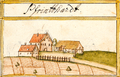
Pfundhard 1683


In 1777 the old town hall was built on the market square.
19th century
When the new administrative structure in the Kingdom of Württemberg was implemented at the beginning of the 19th century, Weilheim remained assigned to the Oberamt Kirchheim .
At the end of the 19th century, industrial development began hesitantly. The Kirchheim-Weilheim post office was set up in 1858, a weaving mill was established in 1884, the first largest industrial enterprise, and in 1908 the Kirchheim (Teck) Süd – Weilheim (Teck) railway was put into operation, on which passenger traffic ceased on September 25, 1982 became, in 1986 the freight transport.
20th and 21st centuries
From 1922 to 1924, the city's water supply was established through water pipes.
From 1934 to 1937 the A 8 motorway was built, which runs through the district in the far north. The administrative reform during the Nazi era in Württemberg led to Weilheim's membership in the Nürtingen district in 1938 . On the Bosler , a rock on the Albtrauf, several aircraft have had an accident since 1940 when they hit the abruptly rising mountain.
After the Second World War, Weilheim belonged to the state of Württemberg-Baden in the American zone of occupation . When Baden-Württemberg was founded in 1952, Weilheim became part of today's federal state. Due to the district reform in Baden-Württemberg in 1973, Weilheim became part of the Esslingen district . In 1975 an administrative community was set up with the communities of Bissingen , Holzmaden , Neidlingen and Ohmden .
In 2009 the town hall received a modern extension with an underground car park.
Incorporations
On January 1, 1972, the community of Hepsisau was incorporated into Weilheim. The coat of arms of the old community, adopted in 1952, shows a golden diagonal right-hand bar in blue, covered with a natural cherry branch. Hepsisau is located around 4 kilometers from Weilheim directly on the Albtrauf and today has around 750 inhabitants. While the local nobility, the Lords of Hepsisau, is documented as early as 1237 and 1241, the community itself appears for the first time in 1504. Far beyond the district boundaries, it is known that under the auspices of the Esslingen district standing Schullandheim Lichteneck .
Population development
The population figures are census results (¹) or official updates from the State Statistical Office ( main residences only ).
|
politics
Municipal council
The municipal council consists of the elected voluntary councilors and the mayor as chairman. The mayor is entitled to vote in the municipal council. In Weilheim, the municipal council is elected according to the procedure of the false sub-district election. The number of local councils can change due to overhang mandates . The municipality council in Weilheim has 18 members after the last election (unchanged). The local elections on May 26, 2019 led to the following final result.
| Parties and constituencies | % 2019 |
Seats 2019 |
% 2014 |
Seats 2014 |
|||
|---|---|---|---|---|---|---|---|
| FWV | Free voter association Weilheim an der Teck | 30.49 | 6th | 40.05 | 7th | ||
| UWV | Independent voter association Weilheim an der Teck and Hepsisau | 27.31 | 5 | 30.21 | 6th | ||
| SBV | Social citizens' association Weilheim an der Teck | 23.41 | 4th | 29.74 | 5 | ||
| BDF | Citizens' Democratic Group Weilheim an der Teck | 18.45 | 3 | - | - | ||
| total | 100 | 18th | 100 | 18th | |||
| voter turnout | 61.48% | 52.81% | |||||
mayor
- 1889–1916: Stadtschultheiß Scheu
- 1916–1937: Karl Schmid
- 1937–1972: Georg Kandenwein
- 1972–2009: Hermann Bauer (Free Voters)
- since April 1, 2009: Johannes Züfle (independent)
In the mayoral election on January 29, 2017, none of the applicants could achieve the required majority. On February 12, incumbent Züfle was re-elected with 56.07% of the vote.
coat of arms
Blazon : Under the golden head of the shield , covered with a lying black deer pole , a blue key in silver.
The coat of arms has been passed down since around 1600 and has been in use in its current form since at least 1907. The stag pole - half an antler - indicates that the city belongs to Württemberg . The key is reminiscent of the symbol of the patron St. Peter of the St. Peter's Church in Weilheim . The white and blue flag has been legally used since at least the beginning of the 20th century.
Economy and Infrastructure
traffic
.jpg)
Coming from Neidlingen in the southeast and following the Lindachtal, the L 1200 crosses Weilheim and continues to Kirchheim unter Teck in the northwest. The L 1252 connects to the west with Dettingen unter Teck , the L 1214 in the direction of Aichelberg offers connection to the A 8 after less than 2.5 km from the town center via the Aichelberg slip road . Like this, the L 1213 climbs eastward over the Albtrauf and leads to Gruibingen.
At Kirchheim unter Teck train station, which is about 9 km away on the road, the people of Weilheim have a connection to the Teckbahn . Until 1982 the city had a direct rail connection via the Kirchheim (Teck) Süd – Weilheim (Teck) railway. The line has been idle since 1994, but it is planned to reactivate it for passenger transport.
The Alb-Neckar cycle path reaches Weilheim as a long-distance cycle path . It leads from Ulm to Heilbronn .
Viticulture
Weilheim is the most southeastern branch of the Württemberg wine-growing region , whose Weilheim single location Schlosssteige belongs to the large Hohenneuffen location in the Remstal-Stuttgart area.
Established businesses
- Fischer Weilheim GmbH, earthworks, demolition work, transport work
- Hans Fischer Transport GmbH, a national freight forwarding and logistics company
- Wilhelm Kächele GmbH, leading manufacturer of special rubbers (e.g. for oil production ) and rubber-metal compounds
- Kurt Hack GmbH (Eurotramp-Trampoline), trampoline manufacturer
- CNC-Technik Ortlieb GmbH & Co.KG, metal processing company in the field of machining
Educational institutions
In addition to the Realschule and the elementary and secondary school with Werkrealschule, there is also a pure elementary school in the city, the Limburg School. A special school rounds off the school offer. The high school students of the community move to the secondary school in Kirchheim unter Teck . There are also five municipal kindergartens on site, the “Free Kindergarten Weilheim e. V. “and the Waldkindergarten Weilheim e. V.
In 2012, the city library, which is housed in a listed building, borrowed almost 142,000 items from its stock of 28,000 media. From July 1, 2013 the offer will be digitally expanded; " Onleihe " is then possible for registered readers .
Leisure and sports facilities
- The Lindach Stadium, home of the Weilheim gymnastics and sports club with adjoining tennis and soccer fields, a basketball field , a bike park and a skate park .
- Egelsberg sports field (soccer field)
- Riding facility (Egelsberg)
Culture and sights
Buildings
- The Peterskirche with rich furnishings was built in 1489 in the late Gothic style and is now a cultural monument. It replaced a church from 1089.
- Capuchin house
- Community center
- The town hall on the market square was built in 1777.
- Lion shear
Regular events
- City festival , every year on the first Sunday in July
- Village festival in Hepsisau, every year on the first Sunday in September
- Cherry blossom festival in April
- Advent market , every year on the 2nd Advent
Natural monuments
- Sessile oak on Kinderwasen with a chest height of 6.50 m (2015).
Personalities
Honorary citizen
- Christian Mali (1832–1906), professor and painter
- Emil Paillard (1859–1945), general practitioner
- Georg Kandenwein, mayor from 1937 to 1972
- Karl Gottlob Dreher (1886–1979), former rector. D., author of the home book Weilheim / Teck, then and now , Volumes I + II
- Hermann Bauer, mayor from 1972 to 2009
sons and daughters of the town
- Friedrich von Gerok (1786–1865), theologian, general superintendent of Ludwigsburg, member of the state parliament
- Richard Döcker (1894–1968), architect and university professor
- August Hermann Hinderer (1877–1945), theologian and publicist
- Sabine Hirler (* 1961), music teacher, music therapist, author, composer and lecturer
- Jannik Steimle (* 1996), racing cyclist
Personalities who have worked on site
- Josef Schwarz (1910–1985), expellee politician (CDU), member of the state parliament, lived in Weilheim and was also a local councilor here
- Gerhard Dreher (1924–2008), freelance visual artist, lived in Weilheim for a long time
- Moritz Rugendas (1802–1858), painter and explorer, died in Weilheim
Culinary specialties
In Weilheim and the surrounding area, people like to eat the Bätscher , a pizza-like pastry that is coated with a sour cream mixture and garnished with caraway seeds and pieces of bacon .
literature
- Christoph Bizer: Hepsisau - from the story of a village at the foot of the Alb. Edited by the city of Weilheim ad Teck, 1987, ISBN 3-9800255-2-7 .
- Karl Dreher: Weilheim an der Teck then and now. A. Gottliebs & J. Oßwalds Buchdruckereien, Kirchheim unter Teck 1939
- Hans Schwenkel : Home book of the Nürtingen district . Volume 2, Würzburg 1953, pp. 1173-1217.
- Ulrich Marstaller: The Peterskirche in Weilheim . Konrad Theiss Verlag, Stuttgart 1985, ISBN 3-8062-0436-5 .
- The Esslingen district (Volume 2). Edited by the State Archives Baden-Württemberg i. V. with the district of Esslingen, Jan Thorbecke Verlag, Ostfildern 2009, ISBN 978-3-7995-0842-1 , page 437.
- Manfred Waßner u. a., The history of the city on Limburg . Weilheim an der Teck 2007, ISBN 978-3-00-021110-2 .
Individual evidence
- ↑ State Statistical Office Baden-Württemberg - Population by nationality and gender on December 31, 2018 (CSV file) ( help on this ).
- ↑ State Statistical Office, area since 1988 according to actual use for Weilheim an der Teck.
- ↑ "It rattled like a truck unloading tin cans" - data protection - Teckbote .
- ^ Federal Statistical Office (ed.): Historical municipality directory for the Federal Republic of Germany. Name, border and key number changes in municipalities, counties and administrative districts from May 27, 1970 to December 31, 1982 . W. Kohlhammer, Stuttgart / Mainz 1983, ISBN 3-17-003263-1 , p. 454 .
- ↑ Election result of the municipal council election 2019 .
- ↑ a b Results of the mayoral election 2017 .
- ^ Entry in the directory of monumental oaks . Retrieved January 10, 2017
Web links

Aichtal | Aichwald | Altbach | Altdorf | Altenriet | Baltmannsweiler | Bempflingen | Beuren | Bissingen on the Teck | Deizisau | Denkendorf | Dettingen under Teck | Erkenbrechtsweiler | Esslingen am Neckar | Filderstadt | Frickenhausen | Großbettlingen | Hochdorf | Holzmaden | Kirchheim unter Teck | Kohlberg | Kings | Leinfelden-Echterdingen | Lenningen | Lichtenwald | Neckartailfingen | Neckartenzlingen | Neidlingen | Neuffen | Neuhausen on the Fildern | Notzingen | Nürtingen | Oberboihingen | Ohmden | Ostfildern | Owen | Plochingen | Reichenbach an der Fils | Schlaitdorf | Unterensingen | Weilheim an der Teck | Wendlingen am Neckar | Wernau (Neckar) | Wolfschlugen
Germany: Bräunlingen | Freiburg im Breisgau | Neuchâtel am Rhein | Offenburg | St. Peter | Villingen | Weilheim an der Teck
Switzerland: Bern | Burgdorf | Freiburg | Murten | Rheinfelden | Tuna