
Alb-Neckar cycle path
| Alb-Neckar cycle path | |||||||||||||||||||||||||||||||||||||||||||||||||||||||||||||||||||||||||
|---|---|---|---|---|---|---|---|---|---|---|---|---|---|---|---|---|---|---|---|---|---|---|---|---|---|---|---|---|---|---|---|---|---|---|---|---|---|---|---|---|---|---|---|---|---|---|---|---|---|---|---|---|---|---|---|---|---|---|---|---|---|---|---|---|---|---|---|---|---|---|---|---|---|
| overall length | 213 km | ||||||||||||||||||||||||||||||||||||||||||||||||||||||||||||||||||||||||
| location |
|
||||||||||||||||||||||||||||||||||||||||||||||||||||||||||||||||||||||||
| Starting point | Ulm | ||||||||||||||||||||||||||||||||||||||||||||||||||||||||||||||||||||||||
| Target point | Heilbronn | ||||||||||||||||||||||||||||||||||||||||||||||||||||||||||||||||||||||||
| Flooring | predominantly paved roads or unpaved gravel roads | ||||||||||||||||||||||||||||||||||||||||||||||||||||||||||||||||||||||||
| Height difference | lowest point: 152 m; highest point: 856 m |
||||||||||||||||||||||||||||||||||||||||||||||||||||||||||||||||||||||||
| difficulty | light | ||||||||||||||||||||||||||||||||||||||||||||||||||||||||||||||||||||||||
| Traffic volume | largely with little traffic on cycle paths | ||||||||||||||||||||||||||||||||||||||||||||||||||||||||||||||||||||||||
| Website URL | Tourismus-bw.de | ||||||||||||||||||||||||||||||||||||||||||||||||||||||||||||||||||||||||
|
Route
|
|||||||||||||||||||||||||||||||||||||||||||||||||||||||||||||||||||||||||
The Alb-Neckar Cycle Path runs over 213 kilometers as a long -distance cycle path from Ulm to Heilbronn through the Stuttgart metropolitan region . It also crosses the eastern part of the Swabian Alb biosphere area . During its course the Alb-Neckar-Radweg overcomes 2100 vertical meters uphill and 2416 vertical meters downhill. The cycle path is usually shown on maps with the abbreviation AN .
Characteristic
One of the demanding sides of the path is overcoming the main European watershed in a low mountain range near Westerheim , where the ascent and descent through the high-lying watershed Atlantic - Black Sea is predetermined. The path is not only characterized by the elevations of the Swabian Alb , but also by the gently sloping river valleys. The following are to be named as examples:
- Danube valley near Ulm
- Blautal at Blaustein and Blaubeuren
- Filstal near Göppingen
- Remstal between Lorch and Remseck
- Neckar valley before Heilbronn
Historical sights along the route
Ruins, castles and palaces

The blades flintlock over the Blautal is achieved in Blaustein.

The Hohengerhausen ruin , the so-called Rusenschloß , becomes visible even before Blaubeuren.

The Reußenstein castle ruins at the beginning of the Neidlinger Valley can be seen on the bike path , standing on a rock.

The Limburg near Weilheim whose surface is of volcanic origin, is almost entirely surrounded by the bike path.
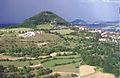
The last two witness mountains of the Swabian Alb that the cycle path reaches at the foot of the mountain: Hohenstaufen with Stauferburg (left) and Rechberg (right in the background), two of three Kaiserberge .


.jpg)

Historic monastery complex
The Söflingen monastery with its wide area becomes visible on the bike path at the end of Ulm.

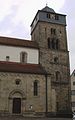
The Blaubeuren monastery on the Blautopf is a former Benedictine monastery and is a stop on the bike path.
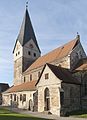
The cycle path in Göppingen leads to the old Faurndau monastery , which dates back to the Romanesque period.

The Lorch Monastery is reached in the Rems Valley. It was once the home of the Hohenstaufen monastery .
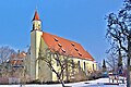
The women's monastery in Oberstenfeld has an old history with its collegiate church .


See also
Web links
Individual evidence
- ↑ Alb Neckar Cycle Path ( Memento from February 28, 2016 in the Internet Archive )
- ↑ http://www.tourismus-bw.de/Media/Touren/Alb-Neckar-Radweg
- ↑ z. B. Topographic hiking map 1:35 000, map of the Swabian Alb Association, sheet 27 Ulm Laupheim, special edition ed. from the Swabian Alb Association , from 2006