
Hohenstaufen (mountain)
| Hohenstaufen | ||
|---|---|---|
 View from west southwest |
||
| height | 684 m above sea level NHN | |
| location | Baden-Wuerttemberg , Germany | |
| Mountains | Swabian Alb | |
| Coordinates | 48 ° 44 '35 " N , 9 ° 42' 59" E | |
|
||
| Type | Zeugenberg | |
| rock | White Jura | |

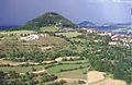
The Hohenstaufen is 684 m above sea level. NHN high, the Swabian Alb upstream Zeugenberg near Göppingen . Its cone is visible from afar and is a striking element of the landscape silhouette around Göppingen. In addition to the Stuifen and the Rechberg , the Hohenstaufen is the westernmost of the closely spaced Drei Kaiserberge between the Remstal in the north and the Lauter and Filstal in the south.
The part of the name staufen corresponds to the old name Stauf for a pointed, conical mountain (derived from the West Germanic adjective * staupa- meaning “steep”).
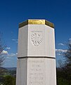
On the mountain the ruins of the family castle is the noble family of the Staufer , the former castle Hohenstaufen . A board on the summit explains the panorama. Since June 1, 2002, a Staufer stele has stood on the mountain in memory of the Staufer era .
There is also a small excursion restaurant there. The summit can only be reached on foot, the shortest from the Hohenstaufen district of Göppingen of the same name .
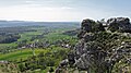
The so-called play castle is located on the south-west slope , a slipped limestone rock group of the adjacent White Jura rock.

View from the north
View from the southwest, right in the background the Rechberg

View of the city and the Hohenstaufen mountain
Staufer stele on the Hohenstaufen

View of the play castle
View from the play castle

Hohenstaufen from Hohrein, drawing by Margret Hofheinz-Döring

View of Spielburg, drawing by Margret Hofheinz-Döring


_Zeichnung_von_Margret_Hofheinz-D%C3%B6ring.jpg)
literature
- Hartmut Schäfer: A refuge on the Hohenstaufen - the start of the Staufer year? In: Preservation of monuments in Baden-Württemberg , 6th year 1977, issue 1, pp. 22–24. ( PDF; 8.6 MB )
Web links
- Virtual 360 ° all-round view of the Stauferstele on the Hohenstaufen (alb360.de)
- Map of Hohenstaufen with further surroundings on: State Agency for the Environment Baden-Württemberg (LUBW) ( information )
- Map of Hohenstaufen with immediate surroundings on: Geoportal Baden-Württemberg ( information )
Individual evidence
- ↑ Map services of the Federal Agency for Nature Conservation ( information )
- ↑ German Dictionary : Stauf , see meaning II.
- ↑ Hohenstaufen 2002 on stauferstelen.net. Retrieved March 23, 2014.