
Hohenlohe-Ostalb-Weg
| Hohenlohe – Ostalb – way | |||||||||||||||||||||||||||||||||||||||||||||||||||||||||||||||||||||||||||||
|---|---|---|---|---|---|---|---|---|---|---|---|---|---|---|---|---|---|---|---|---|---|---|---|---|---|---|---|---|---|---|---|---|---|---|---|---|---|---|---|---|---|---|---|---|---|---|---|---|---|---|---|---|---|---|---|---|---|---|---|---|---|---|---|---|---|---|---|---|---|---|---|---|---|---|---|---|---|

|
|||||||||||||||||||||||||||||||||||||||||||||||||||||||||||||||||||||||||||||
| overall length | 186 km | ||||||||||||||||||||||||||||||||||||||||||||||||||||||||||||||||||||||||||||
| location |
|
||||||||||||||||||||||||||||||||||||||||||||||||||||||||||||||||||||||||||||
| Starting point | Rothenburg ob der Tauber | ||||||||||||||||||||||||||||||||||||||||||||||||||||||||||||||||||||||||||||
| Target point | Ulm | ||||||||||||||||||||||||||||||||||||||||||||||||||||||||||||||||||||||||||||
| difficulty | medium | ||||||||||||||||||||||||||||||||||||||||||||||||||||||||||||||||||||||||||||
| Website URL | Tourismus-bw.de | ||||||||||||||||||||||||||||||||||||||||||||||||||||||||||||||||||||||||||||
|
Route
|
|||||||||||||||||||||||||||||||||||||||||||||||||||||||||||||||||||||||||||||
The Hohenlohe-Ostalb-Weg leads over 186 kilometers as a long-distance cycle path from Rothenburg ob der Tauber to Ulm . During its course, the Hohenlohe-Ostalb-Weg overcomes 2036 vertical meters uphill and 1987 vertical meters downhill. The cycle path is usually shown on maps with the abbreviation HO .
Route character
The path is mostly paved with little traffic, partly gravel roads. On the section from Rothenburg to Wasseralfingen there are some medium gradients, after which the route becomes more level. The route is less suitable for children and the inexperienced, only individual stages are family-friendly.
The Hohenlohe-Ostalb-Weg is not only on the eastern edge of the Swabian Alb , but also in the very east of the state of Baden-Württemberg . It started in Bavaria .

Points of contact
For bike tours in a north-south direction (or in a south-north direction) through southern Germany and Europe, the cycle path is an important link:
- The Taubertal Cycle Path , but also the Jakobsweg Main-Taubertal , represent the continuation to the Main and to northern Germany in the north .
- The Iller cycle path leads to the Alps and Transalp companies in the south .
- The Danube-Lake Constance cycle path leads southwest to Lake Constance and on to Austria or Switzerland .
Sights along the route
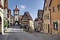
As a medieval town, Rothenburg im Taubertal is both a starting point and a highlight on the way.
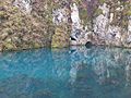
The Hohenlohe-Ostalb-Weg in Königsbronn passes the Brenztopf with its deep blue shimmering spring water.

The Bright Stone Castle stands high above the town of Heidenheim.

The Charlottenhöhle in Hürben is a natural monument of the Ostalb , which the Hohenlohe-Ostalb-Weg leads past. The karst cave is developed for tourism over half a kilometer.


See also
literature
- Long-distance cycle routes in Baden-Württemberg . Bruckmann-Verlag GmbH, Munich, 2011, ISBN 978-3-7654-5567-4 , p. 128
Web links
- ADFC touring portal Hohenlohe-Ostalb-Weg ( Memento from January 16, 2018 in the Internet Archive )
Individual evidence
- ↑ Hohenlohe-Ostalb-Radweg , on tourismus-bw.de
- ↑ z. B. Topographic hiking map 1:35 000, map of the Swabian Alb Association, sheet 27 Ulm Laupheim, special edition ed. from the Swabian Alb Association , from 2006