Kohlberg (Württemberg)
| coat of arms | Germany map | |
|---|---|---|

|
Coordinates: 48 ° 33 ' N , 9 ° 20' E |
|
| Basic data | ||
| State : | Baden-Württemberg | |
| Administrative region : | Stuttgart | |
| County : | Esslingen | |
| Height : | 476 m above sea level NHN | |
| Area : | 4.39 km 2 | |
| Residents: | 2324 (December 31, 2018) | |
| Population density : | 529 inhabitants per km 2 | |
| Postal code : | 72664 | |
| Area code : | 07025 | |
| License plate : | ES, NT | |
| Community key : | 08 1 16 036 | |
| Address of the municipal administration: |
Metzinger Strasse 1 72664 Kohlberg |
|
| Website : | ||
| Mayor : | Rainer Taigel | |
| Location of the municipality of Kohlberg in the Esslingen district | ||
Kohlberg is a municipality in the Esslingen district in Baden-Württemberg . It belongs to the Stuttgart region (until 1992 the Middle Neckar region ) and the European metropolitan region of Stuttgart . Kohlberg and its entire area are part of the Swabian Alb biosphere area .
geography
Geographical location
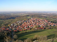
Kohlberg is located on the Albtrauf at an altitude of 357 to 673 meters.
Community structure
Apart from the village of Kohlberg, no other places belong to the community.
Neighboring communities
The following cities and municipalities border on the municipality of Kohlberg, they are named starting in the north in a clockwise direction and belong to the Esslingen district and Reutlingen district ¹: Frickenhausen , Neuffen , Metzingen ¹ and Grafenberg ¹.
Division of space

According to data from the State Statistical Office , as of 2014.
history
Until the 19th century
The traces of settlement in the Kohlberg area go back to the time before the birth of Christ. In Won Middle Wasen were from Jurassic chert tools manufactured salvaged from the Neolithic v, about 3000 to 2000th BC, date. The tools found lead to the conclusion that the inhabitants of the Kohlberg municipality were partly cattle herders, hunters and gatherers . A potty from the Late Bronze Age found on the Jusi proves that the Kohlberg “local mountain” dates back to between 1200 and 800 BC. Was inhabited. This also applies to the Hallstatt period (800–400 BC), from which some burial mounds in the upper Autmuttal come from.
In the 11th century Kohlberg belonged to the area of the Counts of Achalm . The Counts Luitold and Kuno von Achalm gave away large lands to the Zwiefalten monastery in 1098 with the Bempflingen Treaty . The Zwiefalten abbot Ulrich von Hürzbühl had a dwelling ( domicilium ) built in Kohlberg for lay brothers who planted and tended vineyards. Since the end of the 11th century, the Zwiefalten monastery owned other properties in the village of Kohlberg in addition to the domicilium . Two knightly servants of Count von Achalm, Eberhard von Urach and Luitold, gave the monastery three hubs and the freeborn Gisela von Hiltensweiler gave him two hubs with the neighboring forest of Berinbolt .
In the period that followed, there were considerable disputes about the Kohlberger Gut. These took on almost warlike forms in the 15th century when the government of Emperor Frederick III. Lent the court as an inheritance to Vice Chancellor Ulrich Welzli, a native of Göppingen. As a result, in 1461 there was almost a battle between the Counts of Württemberg and - on behalf of the Emperor - the Count Palatine Friedrich. The completely surprising death of Ulrich Welzli made a peaceful solution possible. Based on a comparison of the Zwiefalten monastery with Welzli's brother and heir, the Rottweiler court court awarded the Kohlberger Hof to the Zwiefaltenern again in 1465, who had to pay Welzli 1000 guilders and give him 100 guilders a year for life. In 1467, Frederick III declared that the Kohlberger Hof of the monastery was "own" and not a "fiefdom" and reinstated it in its old rights.
In 1520 the Zwiefalten monastery left the former estate to fiefdom farmers in Neuhausen an der Erms . Also in 1520 Kohlberg became an independent parish after it had previously been a subsidiary of Neuffen.

The benefice divide (tax rights) that nobles and parishes had in Kohlberg came after the Reformation, like that of the Zwiefalten monastery in 1750 to Württemberg. In the 16th century the community did not have its own court, but at that time and probably from ancient times belonged to the court of the city of Neuffen.
The economic life of the population revolved mainly around agriculture until the middle of the 20th century . The fruit and wine growing that dates back to the Zwiefalten Monastery has continued to this day. Linen weaving has demonstrably been practiced in the village since the 17th century.
In the 17th century, the emperor again showed interest in Kohlberg: In the Thirty Years' War , the Württemberg people were defeated in the Battle of Nördlingen in 1634. The emperor then took the entire former county of Achalm, to which Kohlberg belonged, and handed over the property to the Archduchess Claudia of Front Austria. In the Peace of Westphalia in 1648, Kohlberg returned to the care of Württemberg.
In Württemberg Kohlberg initially belonged to the Oberamt Neuffen . In 1806 it came to the Oberamt Nürtingen .
20th century
In 1938 the Oberamt became the District of Nürtingen . During the Second World War, the community was almost completely spared from air raids and the like. From April 23, 1945, the community was occupied. The border between the American and French occupation zones ran right through the community. This was corrected later and the dividing line was then identical to the marking boundary to Metzingen. The community was henceforth under American occupation. With the district reform in 1973, the place was integrated into the Esslingen district.
21st century
Kohlberg was particularly hard hit by the COVID-19 pandemic in Germany at the beginning of April 2020 with 5 deaths and 13 confirmed infections.
Population development
- 1824: 759 inhabitants
- 1848: 887 inhabitants
- 1939: 1,072 inhabitants
- 1950: 1,381 inhabitants
- 1961: 1,504 inhabitants
- 1970: 1,753 inhabitants
- 1980: 2,106 inhabitants
- 1990: 2,225 inhabitants
- 1995: 2,259 inhabitants
- 2000: 2,291 inhabitants
- 2005: 2,321 inhabitants
- 2010: 2,277 inhabitants
- 2015: 2,268 inhabitants
politics
Municipal council
The municipal council in Kohlberg has twelve members. The local elections on May 26, 2019 led to the following final result. The municipal council consists of the elected voluntary councilors and the mayor as chairman. The mayor is entitled to vote in the municipal council.
| Parties and constituencies |
% 2019 |
Seats 2019 |
% 2014 |
Seats 2014 |
||
| FWV | Free electoral association | 47.61 | 6th | 56.2 | 7th | |
| UWV | Independent electoral association | 52.39 | 6th | 43.8 | 5 | |
| total | 100.0 | 12 | 100.0 | 12 | ||
| voter turnout | 68.98% | 52.18% | ||||
mayor
- 1924–1945: Eugen Schäfer
- 1945: Hermann Schaich
- 1945–1948: Richard Arnold
- 1948–1956: Eugen Schäfer
- 1956–1993: Rolf Winkler
- 1993–2008: Frank Buss
- 2008–2016: Klaus Roller
- since 2016: Rainer Taigel
coat of arms
Blazon: In a divided shield above two silver (white) lilies next to each other in blue, below in silver (white) a blue branch with a blue grape and two blue leaves.
The branch of the vine, first recognizable in the mayor's office seal in 1820, is an indication of the viticulture that has been practiced in Kohlberg for centuries. The two lilies come from the coat of arms of Conrad von Achalm, who temporarily exercised the imperial bailiff over the Kohlberghof. The municipality flag has the colors white-blue (silver-blue). The coat of arms was awarded in 1952 by the state government, the flag in 1973 by the Ministry of the Interior.
Culture and sights
- Kohlberg is on the Württemberger Weinstrasse with many sights.
- Regular village festivals are the cherry festival and the Kohlberger wine festival.
Buildings
- Wine press, built in 1579
- Evangelical Church, built in 1768 by Wilhelm Friedrich Goez
Natural monuments
- The Jusi is 673 m high. From there, the hiker has a unique panoramic view of Swabia . From the Hohenzollern to the Kaiser Mountains, the view extends far over the Neckar Valley, the Swabian Forest and the Filder to the Black Forest .
societies
- The local branch of the Swabian Alb Association , founded in 1892, was awarded the Eichendorff plaque in 1992 .
Sons and daughters of the church
- Christian Nathanael von Osiander (1781–1855), theologian, general superintendent of Ulm, member of the state parliament
- August Holder (1850–1918), literary historian and local historian
- Philipp Jakob Manz (1861–1936), industrial architect
Individual evidence
- ↑ State Statistical Office Baden-Württemberg - Population by nationality and gender on December 31, 2018 (CSV file) ( help on this ).
- ↑ State Statistical Office, area since 1988 according to actual use for Kohlberg.
- ↑ Andreas Pflüger: The virus at the funeral service . In: Stuttgarter Nachrichten . tape 75 , April 7, 2020 ( online ).
literature
- Hans Schwenkel : Home book of the Nürtingen district. Volume 2. Würzburg 1953, pp. 539-555.
- Rolf Winkler et al .: Kohlberg - Perle am Jusi. Geiger, Horb 1991, ISBN 3-89264-640-6 .
- Andreas Schmauder (Ed.): Kohlberg - Past and Present. Kohlberg parish, 1993.
- The Esslingen district. - Edited by the State Archives Baden-Württemberg i. V. with the district of Esslingen, Jan Thorbecke Verlag, Ostfildern 2009, ISBN 978-3-7995-0842-1 , volume 2, page 95.
- Kohlberg municipality: Kohlberg - village between mountain and valley. Half a century in pictures . Geiger-Verlag, Horb 1984.


