Jusi
| Jusi | ||
|---|---|---|
|
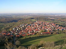
Hörnle (left), Jusi (center) and ruin Hohenurach (right), from the Filder seen from |
||
| height | 672.6 m above sea level NHN | |
| location | Baden-Wuerttemberg , Germany | |
| Mountains | Swabian Alb | |
| Coordinates | 48 ° 32 '59 " N , 9 ° 20' 21" E | |
|
|
||
| Type | extinct volcanic vent | |
| rock | basalt | |
| Age of the rock | Miocene | |

The Jusi , also Jusiberg or Jusenberg , is 672.6 m above sea level. NHN high mountain on the Albtrauf south of Kohlberg and east of the Neuffen district of Kappishäuser in the Esslingen district in Baden-Württemberg .
Surname
The origin of the name Jusi is unclear, has been explained in various ways and remains speculation.
Possibly the name belongs to the evidence of Celtic or pre-Celtic names, such as the river names Neckar , Erms , Fils etc. a. Since the Jusiberg is a landmark that can be seen from afar, it could have been named early on and its name may have been passed on to new immigrants.
According to another theory, it is said to be derived from the Latin word ius (German 'law'), which could indicate a former legal special position of the mountain. It is claimed - without citing the source - that the Jusi represented the border between the various areas of rule around Nürtingen and Reutlingen for centuries . However, the mountain stands in the old Württemberg area and is surrounded by such a thing all around (offices of Nürtingen, Neuffen and Urach). In addition, it would be more than unusual if the Latin word ius had found its way into a geographical name for a border here alone . There is no evidence of similar names in the region - despite the large number of historical borders, especially in southwestern Germany, which was once territorially divided. There, names with reference to a border (Slavic loan word) are usually derived from the old Germanic word Mark , which also lives on in the terms Markung or Gemarkung .
Another interpretation derives the name form Jusenberg from the name Klausenberg - because that is how the mountain is called on the southern border of the municipality of Dettingen an der Erms. Its determining element Klaus can come from Klause (seat of a hermit ) or from the saint and personal name Nikolaus . But there are neither archaeological nor written evidence for this either.
description
The Jusi is the largest volcanic vent in the Swabian volcano . It is the spur of a narrow, almost 4 km long mountain ridge, over which it is connected to the plateau of the Swabian Alb .
With its juniper heather bordered by forest and the Hörnle ( 706.6 m above sea level ) adjacent to the east , which served as a quarry for a long time and about half of it has been removed on the north side, the Jusi is one of the most noticeable elevations in the area of the night eaves . The limestone of the Hörnle (also Dettinger Hörnle ) was once transported by cable car to Neuffen and from there by valley railway to the Nürtingen cement works. There it was used to make cement .
The northern slope with the lime grass lawn used as a sheep pasture and the surrounding beech and oak forests, which provide a habitat for some rare animal and plant species, were declared a landscape protection area in 1935 and have been a nature reserve since 1992. The former Hörnle quarry is also a nature reserve under the name Neuffener Hörnle-Jusenberg . In the area closed by a fence, for example, the threatened yellow-bellied toads occur.
On a clear day, the Jusi basalt massif offers a view of the northern Black Forest with the Hornisgrinde , the Schönbuch and the Fildern , the Neckar Valley , the Swabian Forest and the three Kaiser Mountains (Hohenstaufen, Rechberg and Stuifen) with the adjacent Kalten Feld .
geology
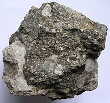
The eroded Jusi of today is one of around 350 volcanoes of the Urach-Kirchheimer volcanic area ( Swabian volcano ), a tectonic phenomenon of the Miocene (geological unit; tectonically particularly active time around 17 million years ago). It consists of concentric layered tuff with white jurassic blocks. In some places large coherent layers of white Jurassic stones are exposed on the present land surface of the former chimney filling. In the north of the mountain you can also find floor clay . At that time the volcanic vent formed a bowl-shaped maar sunk into the plateau of the Swabian Alb . The prominent crest of the Jusiberg was carved out by the erosive relocation of the Alb eaves .
Others
The Jusi meeting, which has been held annually at the Jusi since 1919 (2019 on July 28th) is considered the first “church-in-the-green” event in Germany. It is organized by the Württemberg community association “Die Apis” and the Protestant youth organization.
See also
- Jusi - On the mountain , nature reserve
- Albtrauf Kohlberg , landscape protection area
literature
- Nature reserve Jusi - auf dem Berg , Verlag Regionalkultur, Ubstadt-Weiher 1999, ISBN 3-89735-102-1 .
Web links
Individual evidence
- ↑ Map services of the Federal Agency for Nature Conservation ( information )
- ^ J. Baier: The Urach-Kirchheimer volcanic area of the Swabian Alb. - Exposure 71 (4), 224-233, 2020.
- ↑ J. Baier: The Jusi near Metzingen - a volcanic vent on the Albrand . - Fossils 32 (3), 40-45, 2015.
- ↑ Kretschmann at Jusi-Treffen: Bringing in debates. idea, July 29, 2019, accessed July 30, 2019 .
- ↑ The rain put a spell on the open air anniversary. Der Teckbote, July 29, 2019, accessed on July 30, 2019 .


