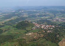
Three Kaiser Mountains
The three Kaiserberge Hohenstaufen ( 684 m above sea level ), Rechberg ( 708 m above sea level ) and Stuifen ( 757 m above sea level ) are witness mountains of the Swabian Alb and form a striking group of three between Göppingen and Schwäbisch Gmünd , which can be seen from afar shapes. Together with the Aasrücke and Rehgebirge mountains , the Drei Kaiserberge have been a protected landscape area since October 4, 1971 .
The name Kaiserberge comes from the fact that the Hohenstaufen was the ancestral castle of the royal and imperial family of the Staufer . The remains of the castle can still be seen, as well as the better-preserved ruins of a Staufer Dienstmannenburg on the neighboring Rechberg.
The city of Göppingen and the community of Waldstetten have stylized the three Kaiserberge in their city / community logo.
The Albmarathon , which takes place annually in October, leads over all three Kaiserberge.
Individual evidence
- ↑ Ordinance of the regional council of North Württemberg on the landscape protection area Hohenstaufen, Rechberg, Stuifen with Aasrücke and Rehgebirge in the districts of Göppingen and Schwäbisch Gmünd from October 4, 1971 (Journal of Laws of 1971, p. 479)


