
Reichenbach an der Fils
| coat of arms | Germany map | |
|---|---|---|

|
Coordinates: 48 ° 43 ' N , 9 ° 28' E |
|
| Basic data | ||
| State : | Baden-Württemberg | |
| Administrative region : | Stuttgart | |
| County : | Esslingen | |
| Height : | 276 m above sea level NHN | |
| Area : | 7.43 km 2 | |
| Residents: | 8431 (Dec. 31, 2018) | |
| Population density : | 1135 inhabitants per km 2 | |
| Postal code : | 73262 | |
| Area code : | 07153 | |
| License plate : | ES, NT | |
| Community key : | 08 1 16 058 | |
| LOCODE : | DE RFI | |
| Address of the municipal administration: |
Hauptstrasse 7 73262 Reichenbach an der Fils |
|
| Website : | ||
| Mayor : | Bernhard Richter | |
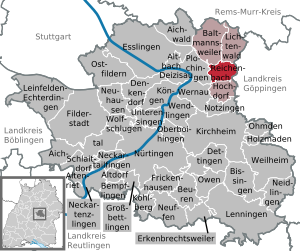
| Location of the municipality of Reichenbach an der Fils in the Esslingen district | ||
  |
||

Reichenbach an der Fils is a municipality in the Esslingen district in Baden-Württemberg . It belongs to the Stuttgart region (until 1992 the Middle Neckar region ) and the European metropolitan region of Stuttgart . There is a community administration association with the communities of Baltmannsweiler , Hochdorf and Lichtenwald .
geography
Geographical location
The municipality of Reichenbach an der Fils is about 12 km (as the crow flies) east-southeast from the district town of Esslingen and in the same direction about 12 km from that of the state capital Stuttgart . It is located on the Fils , which flows westwards here , to which the Reichenbach flows from the north and the Lützelbach from the northwest, and then the Talbach from the southeast . The municipality is predominantly right of the river, its northern part belongs to the subspace virgin forest of the natural area Schurwald and Welzheimer forest to be smaller south along the river to the foothills of the central Swabian Alb . The lowest point at about 253 m above sea level. NN is at the outflow of the Fils, the Probst forest knoll with the highest reaches in the northeast up to 446 m above sea level. NN .
Community structure

Apart from the village of Reichenbach, no other places belong to the municipality of Reichenbach an der Fils. The localities Bornhausen or Bernhausen, Geroldsweiler or Gerensweiler and Knollenhof are in the area of the municipality .
Neighboring communities
The municipality of Reichenbach an der Fils borders in turn on the following municipalities: the municipality of Hochdorf in the south, the city of Plochingen in the west, the municipalities of Baltmannsweiler in the northeast and Lichtenwald in the northeast, all also in the district of Esslingen , and the city of Ebersbach an der Fils in the east in the district of Göppingen .
Division of space

According to data from the State Statistical Office , as of 2014.
history
From the Stone Age to the Middle Ages

Traces of people from the Middle Stone Age (12,000–5,000 BC) were found on the heights of the Filstal valley, as well as on the area north of the Siegenhof.
Reichenbach an der Fils was first mentioned in a document in 1268. However, as in many places, the exact hour of birth lies in the dark of history. The founding time of the place can be inferred from the field names and in comparison with neighboring places. It should have been between the 9th and 11th centuries. Reichenbach was thus a village in the Duchy of Swabia . Wilhelm Böhringer and Gustav Wohlbold, both former teachers at the local elementary school , have researched the state and church archives in the past and found the place to be mentioned for the first time in connection with a dispute between two noble women as "Marquardus plebanus de Richenbach". This "people priest Marquard" is recorded as a witness on a document from 1268. The place name has nothing to do with wealth. Rather, it is named after the stream flowing through the community. In order to avoid confusion with communities of the same name, the place name "Reichenbach an der Fils" was introduced in 1906. At the end of the 13th century, Reichenbach came under the sovereignty of the Lords of Württemberg , after the Hohenstaufen and then the Dukes of Teck had been in charge. In 1299, Duke Hermann von Teck surrendered all ownership and rule claims in Reichenbach to Württemberg.
Development in the early modern period
In 1534 the evangelical Duke Ulrich ordered that Württemberg and thus Reichenbach as well should be evangelical from now on in accordance with the principle " Cuius regio, eius religio ". Originally, Reichenbach belonged to the office in Kirchheim , from 1485 to the office in Göppingen . The community developed slowly. When Spanish, Swedish, Austrian and above all French troops marched through the Filstal for almost 300 years from the 16th to 19th centuries during the recurring times of war, Reichenbach became a theater of war through occupations, looting and fighting. Even Napoleon traveled through the place in 1806.
After the place had already had 600 inhabitants, Reichenbach was almost depopulated after the Thirty Years War and only had about 50 inhabitants. It was one of the worst devastated places in the Göppingen district. It took 180 years for the place to recover from those dire times. Only at the beginning of the 19th century was there any noticeable immigration. In the economic history of the early Duchy of Württemberg, Reichenbach had functioned as a mining site for a long time. As early as the 15th century, the Counts and later dukes of Württemberg had copper and manganese ores digged in the Asang and Lützelbachtal, from which colors were extracted. In 1457 a coal mine was built in the direction of Baltmannsweiler . In the sandstone there were not only occasional small coal seams, but also traces of gold and silver. At times, more than six tunnels were in operation. A smelter was built in 1561, but after several interruptions, mining was stopped in 1739 due to insufficient production.
After the founding of the Kingdom of Württemberg
When the new administrative structure was implemented in the Kingdom of Württemberg , founded in 1806 , Reichenbach remained assigned to the Oberamt Göppingen . The upswing in Reichenbach coincides with industrialization . It was of great importance that Reichenbach became a train station with the opening of the Filstalbahn in 1847 and thus got a connection to the route network of the Württemberg railway as well as to the national transport routes. The establishment of the Heinrich Otto cotton spinning and weaving mill in 1879 brought further growth.
Since the 20th century
The administrative reform during the Nazi era in Württemberg led to Reichenbach becoming part of the Esslingen district in 1938 . After the Second World War, Reichenbach belonged to the state of Württemberg-Baden in the American zone of occupation . When Baden-Württemberg was founded in 1952, Reichenbach became part of what is now the federal state.
Religions
Since Duke Ulrich introduced the Reformation in 1534 , Reichenbach has been evangelical . The entire Protestant parish Reichenbach belongs to the Esslingen parish of the Evangelical Regional Church . After the Second World War, a Roman Catholic community emerged again . The Catholic Church of St. Michael was built in 1954 and given its own parish in 1959. Today the community belongs to the Neckar-Fils pastoral care unit in the Esslingen-Nürtingen deanery in the Rottenburg-Stuttgart diocese . There is also a New Apostolic congregation in Reichenbach.
Population development
| year | 1653 | 1871 | 1900 | 1925 | 1950 | 1970 | 1980 | 1990 | 1995 | 2000 | 2005 | 2010 | 2015 |
|---|---|---|---|---|---|---|---|---|---|---|---|---|---|
| Residents | 150 | 970 | 1,481 | 2,349 | 4,517 | 8,111 | 7,261 | 7,361 | 7,424 | 8,022 | 8,029 | 7,936 | 8,236 |
politics
Municipal council
The municipal council in Reichenbach has 18 members. It consists of the elected honorary councilors and the mayor as chairman. The mayor is entitled to vote in the municipal council. The local elections on May 26, 2019 led to the following final result:
| Parties and constituencies |
% 2019 |
Seats 2019 |
% 2014 |
Seats 2014 |
||
| SPD | Social Democratic Party of Germany | 22.02 | 4th | 26.92 | 5 | |
| FW | Free voters Reichenbach an der Fils | 28.74 | 5 | 26.52 | 5 | |
| CDU | Christian Democratic Union of Germany / Independent Citizens | 23.64 | 4th | 25.67 | 4th | |
| GREEN | Alliance 90 / The Greens | 25.61 | 5 | 20.89 | 4th | |
| total | 100.0 | 18th | 100.0 | 18th | ||
| voter turnout | 59.35% | 48.72% | ||||
coat of arms
Blazon : "Under a golden shield head, inside a deer pole, in red a silver ploughshare."
The first evidence of the old village coat of arms is a coat of arms stone from 1588 on the town hall in Reichenbach, which shows it next to the sign of the official town of Göppingen responsible at the time. A ploughshare is connected to the stag as a sign of Württemberg sovereignty in the Schildhaupt, which was a popular symbol in the village and can be traced on Reichenbach boundary stones in 1685 as a mark of spots according to the Kieser Forestry Camp Book ; However, it is undoubtedly older than the illustration from 1588. Today's coat of arms design is attested in newer municipal seals and since 1930 also in the colors that are now in use.
flag
The municipality flag is red and yellow (1966).
Community partnerships
There is a community partnership between the community of Reichenbach an der Fils and the French city of Sainte-Savine .
Economy and Infrastructure
The community suffered badly due to the economic change in the 1990s. At the beginning of the decade the Otto company closed in Reichenbach. The Traub lathe GmbH & Co. KG (the Hermann-Traub Stadium of VfB Reichenbach is named after its founder) has been a subsidiary of the Esslingen-based INDEX-Werke since 1997 , which led to massive job cuts at the time. Other companies are the corrugated cardboard manufacturer Seyfert GmbH, the transport and logistics company Kraftverkehr Nagel Kurt Nagel GmbH & Co., the electrical appliance manufacturer Electrostar , the plastics processor Oskar Voltz GmbH and other medium-sized and small companies.
traffic

The four-lane federal highway 10 , a busy road in southern Germany, runs through Reichenbach . There are also cross-connections via Baltmannsweiler or Lichtenwald into the Remstal and the road via Hochdorf and Notzingen to Kirchheim unter Teck .
Stuttgart can be reached by car via the B 10 in around 25 minutes, and Stuttgart Airport in around 25 minutes.
The railway has been running through Reichenbach since 1847. It is the busy Filstalbahn from Stuttgart to Ulm , on which the ICE and the TGV also run. The Reichenbach station building was renovated in autumn 2006. Today there is a restaurant in the building and it is also a residential building. The stop is served by regional railways and regional express trains between 5 a.m. and 1 a.m. There are also bus connections to Lichtenwald and Schorndorf , to Hochdorf and Kirchheim unter Teck and to Plochingen. The local bus serves the districts of Risshalde and Siegenberg. An important traffic structure is the Sainte-Savine-Brücke , which is named after Reichenbach's partner municipality Sainte Savine in France . It opens up the Voralb area and provides connections to the outdoor pool and the stadium. Shortly after the railway underpass comes the Filsbrücke, which was built in 1877. Until 2007 there was also a small shunting area with a siding to the above mentioned. Corrugated cardboard factory. The track systems were completely removed during the renovation work in 2007. Since there is no longer a passable switch in Reichenbach station due to the disused siding , the station was downgraded to a stop in autumn 2009 .
There is also the Otto-Munz-Steg for pedestrians and cyclists. It spans the railroad tracks, Filsstrasse, the B 10 expressway and the Fils and makes it easier to get to the swimming pool and stadium.
Neighboring communities are Plochingen, Hochdorf , Hochdorf district of Ziegelhof, Ebersbach an der Fils , Lichtenwald-Hegenlohe and Baltmannsweiler . Plochingen and Ebersbach can be reached by train, the other municipalities by bus.
Educational institutions
In addition to a secondary school, Reichenbach also has a primary and secondary school, the Lützelbachschule. The well school, which was a pure elementary school, was closed. The branch of the Marquard School Plochingen, a special needs school , rounds off the school offer. A school in Reichenbach was first mentioned in 1580. In the 16th and 17th centuries, however, people only went to school in winter. A summer school met with resistance from the population because the children had to work in the fields, although schooling was compulsory from 1649. An energetic teacher is said to have achieved that one was taught at least on Tuesday and Friday in the summer. It was not until 1735 that learning was open all year round. The first schoolhouse was a building on Kirchstrasse, built in 1738, which is no longer there today. In 1825 the community built a new school building on Schulstrasse and in 1897 the eastern half of the fountain school was built. The western section of what was then the elementary school was built in 1912. In 1953 the first buildings of the Lützelbachschule in Brühl were built, which was a great financial challenge for the community. School gym and sports field were added five years later. In 1976 the building of the secondary school was built. The secondary and secondary school students from Hochdorf and Lichtenwald are also taught in this training center. The secondary school building also houses the local library with more than 22,000 books as well as cassettes, DVDs and videos.
The first kindergarten was opened in Kirchstrasse in 1844, but was probably not open all year round until the end of the 19th century. However, only those children who were still too young for field work were brought to the “Kender School”. Today there are eight kindergartens in Reichenbach: Robert-Schöttle-Kindergarten, Oskar-Voltz-Kindergarten, Siegenberg-Kindergarten, Michaelis-Kindergarten, Steinäcker-Kindergarten, Clärchen-Seyfert-Kindergarten as well as a forest kindergarten and the Mini-Kindi in the town hall.
Sports
The soccer department of VfB Reichenbach currently plays in the district league A, the chess department, which has now been dissolved, was one of the most successful in the district. The largest sports club in town is the TV Reichenbach with the following departments: competitive gymnastics, general gymnastics, children's sports, health sports, athletics, handball, table tennis, volleyball, fistball, shooters. The lifeguards of the DLRG local group Reichenbach / Fils are also extremely successful nationwide, both in the youth (especially the female swimmers) and among the senior citizens and hold several German championship titles in lifeguarding.
There is also the RSV Reichenbach with the sports of mountain biking, popular sports and cycling.
The Reichenbacher Schützengilde e. V operates shooting sports in the Lützelbachtal according to the rules of the German Shooting Association. In the indoor shooting ranges, rifles and pistols are used to shoot at 10 m, 25 m and 50 m in all DSB disciplines.
Culture and sights
The cultural initiative die halle in the former beer cellar has been offering concerts, cabaret, readings and parties on a regular basis since 1983.
Churches
The Protestant Mauritius Church

The tower of the Mauritius Church dates from 1522. The sandstone used to build the tower of the Mauritius Church was broken in the Lützelbachtal and when the railroad came to Filstal, such ashlars were loaded onto freight wagons and transported to Ulm for the further construction of the Ulm Minster. Since the interior of the church was too small, it was expanded in the Art Nouveau style between 1905 and 1907 according to designs by the Stuttgart architects Richard Böklen and Carl Feil . Today the church has almost 1000 seats. In 1982, the valuable organ with its particularly beautiful Art Nouveau prospectus was costly renewed. In 1997 the interior of the church underwent a thorough renovation, at the same time the somewhat unsuccessful changes of the renovation from 1954 were removed and the church was returned to its original state. Today the Mauritius Church is one of the few art nouveau churches in southwest Germany. The Mauritius church with the rectory, the church forecourt with the fountain and the cemetery behind it together form a listed ensemble.
The Catholic Church of St. Michael
Reichenbach was Catholic until the Reformation , but when Duke Ulrich joined the Reformation in 1534, his subjects also became Protestant. It was not until the beginning of the 20th century that Reichenbach had a significant number of Catholics again, and around 1950 - also due to the influx of displaced persons and refugees during the Second World War - a third of the population was Catholic. In 1953 the construction of the Catholic house of God began. On December 4, 1954, Bishop Carl Joseph Leiprecht consecrated the church to St. Michael the Archangel . In 1988 the church underwent a renovation and today the church can accommodate around 550 visitors. In addition, five bells have been ringing since 1962, which could be bought with donations.
The Protestant Siegenberg Church
In May 1961, the traveling church was built as a wooden barrack. This provisional solution was necessary because the Siegenberg settlement grew rapidly and already had 2000 residents. A few years later, a church building association collected donations, they bought a building site, began building work and inaugurated the church on the 1965 harvest festival . The church, which is furnished with lots of natural wood, houses a church room with 150 seats under its roof, a community hall separated from the church room by a folding wall, and two youth rooms.
The New Apostolic Church
This Christian faith group had ten members in Reichenbach in 1921, and a year later it held the first service. Until 1934 the company had premises on Stuttgarter Straße and then moved to Baltmannsweiler Straße. When there were 60 members, it got too tight there too and so the decision was made to build a church. This was inaugurated on October 27, 1956. The property on Paulinenstrasse was renovated in 1988 and 1989. There are now 120 members.
Reichenbach's town halls
When the first town hall in Reichenbach was built is not known, it is likely to have been around 1590. Its location was near the Fils, which at that time still had its old course and followed today's Seestrasse (the river bed was relocated to the south in 1696 to a length of 800 meters). From the year 1739 there are reports that the town hall must have been in a poor condition and could only be entered at risk of death. But it took eight years before a decision could be made to build a new building. In 1751 a new town hall was completed, which in 1823 was again too small and in need of repair; they rebuilt, renovated and expanded. The house was much too small again since 1900, but they contented themselves with expanding the attic. It was not until 1959 that the local council decided to build a new building, which began on September 4, 1961. The new building was inaugurated on May 29, 1964. The old town hall was demolished because the Südwestbank wanted to build at this point. The bells of the old town hall can be found in the entrance area of the new building - and the tower clock strikes in the fountain school.
Russian cemetery
During the Second World War there was a camp with Russian slave labor in Reichenbach near the train station. According to various sources, between 600 and 1,900 people lived there and had to work in the workshops of the German Reichsbahn. Eleven of the forced laborers who died during captivity were buried in the city cemetery, 28 others, including 15 small children, in a separate cemetery on the outskirts of the city.
Cinemas
The community had three cinemas in the middle of the 20th century. In 1953 the "Central-Lichtspiele" opened. Also in 1953 a second cinema was opened in Wilhelmstrasse, the "New Filmtheater". In addition to the two stationary cinemas, there was also a traveling cinema, which was shown on weekends in the gymnasium of the gymnastics club. The last cinema closed its doors in 1968 on Wilhelmstrasse.
The Brühlhalle
The hall next to the railway lines, built by the gymnastics club in 1907, served as a gymnasium and festival hall for almost 70 years in the absence of a larger event room. When the federal highway 10 was built, the building was torn down. On May 15, 1982 the new Brühlhalle was inaugurated with a ceremony. The construction costs amounted to about 10 million Deutschmarks.
The "outdoor pool in the countryside"
The outdoor pool was opened on May 29, 1976. The Federal Minister of Transport at the time, Volker Hauff, presented a check on this occasion and Mayor Richard Seeger jumped from the diving platform into the water in tails and top hats. In 25 years, over 5 million bathers have passed the turnstiles. As early as 1951 there was an open-air swimming pool, which was located near the Fils weir system and the factory canal of the Otto spinning mill. The Inselbad was closed due to the construction of Bundesstraße 10 .
Buildings

- Brunnengasse
- St. Savine Bridge
- Otto Munz footbridge
- Brühlhalle
- Protestant Mauritius Church
- Protestant Siegenberg Church
- Catholic Michaelskirche
- New Apostolic Church
Personalities
Sons and daughters of the church
- Karl Brönnle (1879–1952), Reichsbahnrat, member of the state parliament (KPD)
- Erich Hoerz (1929–2008), wood engineer, developer of the pedal
- Wolfgang Frank (1951–2013), soccer player and coach
- Sabine Fohler (* 1963), politician (SPD), member of the state parliament (2008–2011)
Lived and worked on site
- Marigard Bantzer (1905–1999), the children's book illustrator, lived in Reichenbach from 1943 after her Berlin apartment was destroyed. Her husband, the illustrator Erich Ohser , who died in 1944 , was buried in Reichenbach until 1968, then the urn was transferred to Plauen .
literature
- Wilhelm Böhringer: Heimatbuch Reichenbach an der Fils. Mayor's office, 1968
- The district of Esslingen - published by the Baden-Württemberg State Archives. V. with the district of Esslingen, Jan Thorbecke Verlag, Ostfildern 2009, ISBN 978-3-7995-0842-1 , Volume 2, page 393.
- Joachim Scherrieble: Reichenbach an der Fils under the swastika - a Swabian industrial village in the time of National Socialism . 2nd edition, which has been reviewed and added to the list of “Reichenbach's fallen and missing persons in World War II”. Silberburg Verlag, Tübingen, ISBN 3-87407-201-0
- Helmut Wurster, Heinz Munz: Reichenbach: a community changes its face [pictures - anecdotes - history] . Ed .: Community of Reichenbach an der Fils. Gottlieb & Osswald, Kirchheim unter Teck, 2001.
Web links
Individual evidence
- ↑ State Statistical Office Baden-Württemberg - Population by nationality and gender on December 31, 2018 (CSV file) ( help on this ).
- ↑ State Statistical Office, area since 1988 according to actual use for Reichenbach an der Fils.
- ↑ Election information for the municipal data center
- ↑ Klemens Stadler: German coat of arms. Volume VIII: Baden-Württemberg Page 87 . With drawings by Max Reinhart. Angelsachsen-Verlag Bremen, 1971.
- ↑ Memorial plaque at Reichenbach train station. Retrieved September 1, 2019 .
- ↑ Article in the Esslinger Zeitung. (PDF) Retrieved September 1, 2019 .
- ^ N-TV: Erich Ohser died 70 years ago - father and son, Gestapo and death, April 6, 2014 .

Aichtal | Aichwald | Altbach | Altdorf | Altenriet | Baltmannsweiler | Bempflingen | Beuren | Bissingen on the Teck | Deizisau | Denkendorf | Dettingen under Teck | Erkenbrechtsweiler | Esslingen am Neckar | Filderstadt | Frickenhausen | Großbettlingen | Hochdorf | Holzmaden | Kirchheim unter Teck | Kohlberg | Kings | Leinfelden-Echterdingen | Lenningen | Lichtenwald | Neckartailfingen | Neckartenzlingen | Neidlingen | Neuffen | Neuhausen on the Fildern | Notzingen | Nürtingen | Oberboihingen | Ohmden | Ostfildern | Owen | Plochingen | Reichenbach an der Fils | Schlaitdorf | Unterensingen | Weilheim an der Teck | Wendlingen am Neckar | Wernau (Neckar) | Wolfschlugen