
Louder (Neckar)
|
Loud Lenninger Loud |
||
 The Lauter in Lenningen (downstream) |
||
| Data | ||
| Water code | DE : 238194 | |
| location |
Swabian Alb
|
|
| River system | Rhine | |
| Drain over | Neckar → Rhine → North Sea | |
| origin | Confluence of the right Weisser Lauter and left Schwarzer Lauter near Lenningen 48 ° 32 ′ 7 ″ N , 9 ° 29 ′ 45 ″ E |
|
| Source height |
562.6 m above sea level NHN Q. Lauter origin of the White Lauter
|
|
| muzzle | near Wendlingen am Neckar in the Neckar Coordinates: 48 ° 41 '4 " N , 9 ° 22' 46" E 48 ° 41 '4 " N , 9 ° 22' 46" E |
|
| Mouth height | over 252.8 m above sea level NHN | |
| Height difference | 309.8 m | |
| Bottom slope | 12 ‰ | |
| length | 25.8 km from Q. der Weißen Lauter |
|
| Catchment area | 191.588 km² | |
| Discharge at the Wendlingen A Eo gauge : 190 km² Location: 1.97 km above the mouth |
NNQ (12/28/1948) MNQ 1929–2009 MQ 1929–2009 Mq 1929–2009 MHQ 1929–2009 HHQ (04/13/1994) |
83 l / s 684 l / s 2.88 m³ / s 15.2 l / (s km²) 36 m³ / s 118 m³ / s |
The Lauter or Lenninger Lauter is a right tributary of the Neckar and rises on the eaves of the Swabian Alb .
course

The Lauter is formed from the confluence of the White Lauter , which rises east of Gutenberg, and the Black Lauter , which rises in Schlattstall . Both streams are fed from several sources on the respective valley edge. The places belong to the district of Esslingen .
It flows through the communities of Lenningen , Owen , Dettingen unter Teck , Kirchheim unter Teck and Wendlingen am Neckar. Its most important tributary is the Lindach near Kirchheim. After a stretch of 27.5 km the Lauter flows into the Neckar near Wendlingen am Neckar.
Catchment area
The Lenninger Lauter drains an area of 191.2 km² in an approximately north-westerly direction to the middle Neckar , which on both sides of the Alb eaves has a share in the Middle Kuppenalb on the upper course and in the Middle Alb foreland on the lower course. At the Alb outlet of the Lauter itself and even more so at the lower right-hand tributary of the Lindach , which is richer in its catchment area , in the direction of which it swings at its mouth, its waters have created large stepped bays.
Starting from the mouth, the watershed soon runs on the east side towards the catchment area of the nearby downward Neckar tributary Fils . Only far to the south near Donnstetten does the dividing line bend to the west, on a section only a few kilometers long to the Römerstein it now runs on the European main watershed against the drainage area of the Danube, into which the distant blue tributary Ach the overground drainage mostly brookless Alb plateau leads away. Thereafter, the catchment area of the Erms , which again runs to the Neckar, borders on a further short stretch in the south and a longer stretch in the southwest , which in turn is replaced as a competitor by the Steinach , the Tiefenbach and finally the Talbach up to the confluence in the west and northwest .
The highest elevation in the catchment area is up to 874 m above sea level. Römerstein towering above the NHN on the southern watershed along the Albtrauf there. In two other places, too, where the watershed follows the Albtrauf, it runs over heights of over 800 m above sea level. NHN , near the Boßler ( 806 m above sea level ) and near the Römerstein on the Albe ( 812 m above sea level ). The northwestern Alb foothills between the eaves bays of Lauter and Lindach in the interior of the catchment area rises on the Asch to a height of 822 m above sea level. NHN and on the Auchtert up to one of 814 m above sea level. NHN .
Tributaries
List of the direct tributaries of the Lauter and its two source branches from the source to the mouth. Water length, catchment area and height according to the corresponding layers on the LUBW online map. Other sources for the information are noted.
Confluence of the Lauter from its source rivers White and Black Lauter at about 480 m above sea level. NHN at the sewage treatment plant between Lenningen -Gutenberg and Lenningen-Oberlenningen.
-
White Lauter , right and eastern upper reaches, 2.9 km and 14.9 km². Rises at about 562.6 m above sea level. NHN said Lauter origin in Lenningen -Gutenberg.
- Donntalbach , from the left and southwest to about 501.5 m above sea level. NHN west of Gutenberg, 2.6 km and 5.1 km². Arises at about 680 m above sea level. NHN southeast of the Sperberseck ruins .
-
Black Lauter , left and southern upper reaches, 1.8 km and 17.2 km². Rises at about 505 m above sea level. NHN of the Lauterquelle near Lenningen-Schlattstall. With a longer left upper course Seltenbach .
- (Inflow from the Schlattstatter Goldloch ), from the right and south to about 500 m above sea level. NHN in Schlattstall, 0.2 km and approx. 0.1 km². The Schlattstaller Goldloch is a karst spring on the lower slope at about the same height as the Lauter spring of the Black Lauter.
- Seltenbach , from the left and southwest to about 497 m above sea level. NHN in Schlattstall, 1.9 km and approx. 13.6 km². Arises up to 560 m above sea level. NHN in the valley basin In der Schrecke south-southeast of Grabenstetten .
- Bergwiesenlauter , from the left and southeast to about 472 m above sea level. NHN about half a kilometer after the confluence of the Lauter upper reaches, 0.9 km and about 0.4 km². Branches on the B 465 on the left edge of the Lenninger Valley at around 481 m above sea level. NHN to the left from the Schwarzen Lauter.
- Tobelbach , from the right and east to below 450 m above sea level. NHN in Oberlenningen , 1.5 km and 3.5 km². Arises at over 640 m above sea level. NHN in the Tobeltal east of Oberlenningen
- Weilbach , from the left and south to less than 500 m above sea level. NHN in Oberlenningen, 1.1 km and 0.8 km². Occurs periodically up to 520 m above sea level. NHN and then the Hirschtal bröller or Höllloch on the valley slope south of Oberlenningen.
- (Bach from the Kellental ), from the left and west to about 429 m above sea level. NHN under the Sulzburg ruins on the southern edge of Lenningen-Unterlenningen, 2.0 km and 1.7 km². Arises at about 670 m above sea level. NHN under the section of the Heidengraben north of Erkenbrechtsweiler .
- Brühlbach , from the right and east to about 423 m above sea level. NHN in Unterlenningen after the Lauterbrücke of the B 465 , 1.0 km and 0.8 km². Arises at over 460 m above sea level. NHN on the eastern edge of Unterlenningen.
- Ehnisbach , from the right and northeast to about 421 m above sea level. NHN at the bridge at Brunnenstrasse in Unterlenningen, 2.1 km and 2.5 km². Rises at about 530 m above sea level. NHN below the ruin Rauber .
- Krötenbach , from the right and east to 395.2 m above sea level. NHN in Lenningen-Brucken, 1.5 km and approx. 1.6 km². Rises at about 505 m above sea level. NHN east of the Bühl .
- Wehrbach , from the left and southwest to below 385 m above sea level. NHN verdolt on the Lauterbrücke of Beurener Strasse in Owen, 2.2 km and 1.3 km². Arises below 525 m above sea level. NHN on the north slope of the bass violin .
- Small Lauter , left division from Brucken ( 405.6 m above sea level ) to Owen (about 385 m above sea level ), 2.1 km and about 1.3 km². Last crosses the Wehrbach.
- City moat , from the right and northeast to below 365 m above sea level. NHN in Owen, 1.1 km and approx. 0.6 km². Arises below 500 m above sea level. NHN under the Teck Castle .
- Säubadbach , from the left and southwest to below 380 m above sea level. NHN in front of the Schießhüttestraße bridge in Owen, 1.1 km and approx. 0.6 km². Arises below 420 m above sea level. NHN in the Säubad .
- (Inflow from the oak wood pond ), from the left and west to 372.8 m above sea level. NHN opposite the sports fields on the northern edge of the north of Owens, 0.7 km and approx. 0.2 km². Arises at about 425 m above sea level. NHN in the Muldengewann oak wood pond .
- Wittumbach , from the right and east to about 370 m above sea level. NHN shortly before the sewage treatment plant to Owen, 1.9 km and approx. 0.7 km². Arises at about 500 m above sea level. NHN on the southern slope of the Hohenbols .
- (Forest edge ditch), from the left and west to about 370 m above sea level. NHN opposite the Owener sewage treatment plant, 0.7 km and approx. 0.2 km². Arises below 420 m above sea level. NHN on the southern edge of the Dettinger community forest.
- (Bach from the Fahrtobel ), from the left and northwest to 361.9 m above sea level. NHN opposite the Upper Water Meadows , 1.4 km and approx. 1.1 km². Arises at about 440 m above sea level. NHN under the Dettinger Käppele .
- (Stream past the sulfur fountain ), from the left and west to below 355 m above sea level. NHN opposite the south-western edge of Dettingen unter Teck , 1.1 km and approx. 0.7 km². Rises at about 430 m above sea level. NHN the Lichtenbergbrunnen under the eponymous Käppele spur.
- Eulengreutgraben , from the left and southwest to about 395 m above sea level. NHN in Dettingen, 1.2 km and approx. 0.5 km². Arises at about 405 m above sea level. NHN under the Sonnenberg .
- Lindach , from the right and southeast to less than 305 m above sea level. NHN in Kirchheim unter Teck , 16.7 km and 100.6 km². Arises as a Pfannenbach at almost 600 m above sea level. NHN south of Neidlingen . Largest inflow with a catchment area that noticeably exceeds that of the Lauter up to there (72.3 km²). At this tributary, the Lauter changes its flow direction from previously north to northwest, continuing that of the inflowing roof.
- Kegelesbach , from the left and south to about 292 m above sea level. NHN , 6.8 km and 5.9 km². Arises below 460 m above sea level. NHN west of Dettingen am Schnarrenberg . Cross just before the mouth the following.
- Factory canal , from the left to below 290 m above sea level. NHN in Ötlingen , 2.5 km. Leaves the Lauter shortly after the tributary of the Lindach in Kirchheim.
- Dupiggraben , from the left and south to about 279 m above sea level. NHN to Ötlingen , 2.6 km and 1.9 km². Arises at about 343 m above sea level. NHN on the edge of the forest west of Lindorf .
- Speckbach , from the left and south to about 278 m above sea level. NHN immediately after the previous one, 1.0 km and 0.7 km². Arises at about 310 m above sea level. NHN on the northern edge of the Rübholz forest .
The mouth of the Lauter from the right and southeast to over 252.8 m above sea level. NHN near Wendlingen in the middle Neckar . The brook is 25.8 km long here from the source of the longer right upper reaches of the White Lauter , and 22.9 km from the confluence with the Schwarzen Lauter on the course with its name. It has a 191.6 km² catchment area.
history
The Celts already roamed the Lautertal in search of food. In ancient times, the Romans built a Limes ( Lautertal-Limes ) and a fort ( Fort Dettingen unter Teck ) in the lowlands of the Talaue to protect it.
Pictures of the Lauter

Karst spring in the "Schlattstaller" side valley. Stone house: Former drinking water well
(Schwarze Lauter)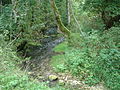
Lauterursprung , karst spring
(White Lauter)
Slowly grown tufa structure in the Gewann “Rinnenwald”, a wooded side valley of the Upper Lenninger Lauter


See also
Individual evidence
LUBW
Official online waterway map with a suitable section and the layers used here: Course and catchment area of the Lauter
General introduction without default settings and layers: State Institute for the Environment Baden-Württemberg (LUBW) ( notes )
- ↑ a b c d e f g h i j Height according to blue lettering on the background layer topographic map .
- ↑ a b Height according to the contour line image on the topographic map background layer .
- ↑ a b c Length according to the waterway network layer ( AWGN ) .
- ↑ a b c d Catchment area totaled from the sub-catchment areas according to the basic catchment area layer (AWGN) .
- ↑ Catchment area according to the basic catchment area layer (AWGN) .
- ↑ a b c d e f g h i j k l m catchment area measured on the background layer topographic map .
Other evidence
- ↑ Hansjörg Dongus : Geographical land survey: The natural spatial units on sheet 171 Göppingen. Federal Institute for Regional Studies, Bad Godesberg 1961. → Online map (PDF; 4.3 MB)
- ^ German Hydrological Yearbook Rhine Region, Part I 2009 State Institute for Environment, Measurements and Nature Conservation Baden-Württemberg, p. 114, accessed on January 22, 2016 (PDF, German, 1.85 MB).
literature
- Topographic map 1: 25,000 Baden-Württemberg, as a single sheet No. 7322 Kirchheim unter Teck, No. 7323 Weilheim an der Teck, No. 7422 Lenningen, No. 7423 Wiesensteig, No. 7522 Bad Urach, No. 7523 Münsingen
Web links
- Map of the course and catchment area of the Lauter on: State Institute for the Environment Baden-Württemberg (LUBW) ( information )
- Measuring table sheets in the Deutsche Fotothek :
- 7322 Kirchheim unter Teck from 1905
- 7323 Weilheim an der Teck from 1905
- 7422 Dettingen ad Erms from 1930
- 7423 Wiesensteig from 1905
- 7522 Urach from 1930
- 7523 Böhringen from 1932