
Heidengraben


The Heidengraben was a in the 1st century BC. BC-used. Celtic settlement , which on the Swabian Alb in grave Stetten was. Originally, the term only referred to the remains of the fortification of the oppidum, which are still visible today as a wall and whose origin could only be clarified at the beginning of the 20th century. The oppidum had an outer and an inner ring of fortifications, inside the latter was the settlement called Elsachstadt (after the Elsach brook, which rises below the oppidum in the Falkensteiner cave ).
Location and history

The oppidum is located on the Grabenstetten peninsula , part of the Alb plateau, which is only connected to the rest of the Alb plateau by a narrow strip south of Grabenstetten, so that the Alb eaves is a natural fortification. This location made it possible to enclose an area of around 16.6 km² by building four short fortifications. These fortifications separated today's area of the municipality of Hülben, the Burgwald area between Beurener Fels and Brucker Fels , the connection to the rest of the Alb plateau and the Lauereck area bordering the inner fortification in the south .
The Elsachstadt settlement had an area of 1.53 km² and was located west of today's municipality of Grabenstetten.

Apparently the Grabenstetten peninsula was settled a few centuries before the oppidum was established. There are graves from around 1000 BC near today's Burrenhof. And some burial mounds that can still be seen today, dating from around 500 BC. Come from BC.
According to the results of a research group at the Institute for Geodesy and Geoinformation Technology at the TU Berlin , this is probably the place Riusiava from the ancient atlas of Ptolemy .
exploration
Contrary to earlier speculations that the Heidengraben came from the Thirty Years' War , the view prevailed in the 19th century that it was an ancient, possibly Roman or Hallstatt relic. Only Friedrich Hertlein recognized in 1905 that it was a Celtic oppidum.
More recently, the State Office for the Preservation of Monuments in Baden-Württemberg and the Eberhard Karls University of Tübingen have carried out excavations at a gate near Erkenbrechtsweiler, the Hallstatt-era burial mound field at the Burrenhof and the land consolidation within the Elsachstadt.
Archaeological finds from the area of the Heidengraben can be seen in a museum in Grabenstetten and in the Kornhaus town museum in Kirchheim unter Teck .
Scientific excavations will take place again in 2019. The Heidengraben plays a major role in the so-called Celtic concept of the state of Baden-Württemberg.
Visible landmarks
- Wall of the Elsachstadt
- Gate system at Erkenbrechtsweiler
- Burial mound field Burrenhof

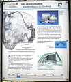
Information board at Heidengraben about the oppidum
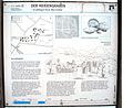
Information board at Heidengraben - about the older settlement of Elsachstadt

Information board at Heidengraben - about the Elsach city in the time of the oppidum
Information board about the Burren (at the Burrenhof)
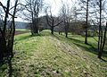
The wall of the Heidengraben (Elsachstadt)


Footnotes
- ↑ On the Grabenstetten peninsula are today's communities of Grabenstetten and Hülben ( district of Reutlingen ), as well as Erkenbrechtsweiler and the Lenningen district of Hochwang ( district of Esslingen ).
- ^ Andreas Kleineberg, Christian Marx, Eberhard Knobloch, Dieter Lelgemann : Germania and the island of Thule. The decoding of Ptolemy's "Atlas of the Oikumene". Scientific Book Society, Darmstadt 2010, ISBN 978-3-534-23757-9 .
- ↑ Magna Germania on googlemaps
- ↑ Waking the Heidengraben from its slumber - NÜRTINGER ZEITUNG. Retrieved July 2, 2019 .
literature
- Franz Fischer : The Heidengraben near Grabenstetten. A Celtic oppidum in the Swabian Alb near Urach. 1971, 3rd edition. 1982, ISBN 3-8062-0317-2 .
- Thomas Knopf: The Heidengraben near Grabenstetten. Archaeological studies on the history of settlement. 2006, ISBN 3-7749-3420-7 .
- The Heidengraben - A Celtic oppidum in the Swabian Alb . Theiss Verlag, 2012, ISBN 978-3-8062-2761-1 .
- Dorothee Ade, Gerd Stegmaier, Andreas Willmy: The Heidengraben. "A mysterious fortification from ancient times". In: Preservation of monuments in Baden-Württemberg. 42nd year 2013, issue 2, pp. 82–87. ( PDF; 7.0 MB )
Web links
- www.heidengraben.com - website with archaeological information
- www.heidengraben-film.de - Website for the documentary film "The Heidengraben - An Almost Undiscovered Celtic Settlement" (About the late Celtic history of the Heidengraben with numerous animated attempts at reconstruction. 3dmuseum.eu 2013)
- www.denkmalpflege-bw.de/denkmale/projekte/archaeologische-denkmalpflege/3d-modelle/heidengraben.html - 3D terrain model of the late Celtic oppidum
Coordinates: 48 ° 32 ′ 0 ″ N , 9 ° 27 ′ 0 ″ E