Grabenstetten
| coat of arms | Germany map | |
|---|---|---|

|
Coordinates: 48 ° 31 ' N , 9 ° 28' E |
|
| Basic data | ||
| State : | Baden-Württemberg | |
| Administrative region : | Tübingen | |
| County : | Reutlingen | |
| Height : | 688 m above sea level NHN | |
| Area : | 14.53 km 2 | |
| Residents: | 1642 (December 31, 2018) | |
| Population density : | 113 inhabitants per km 2 | |
| Postal code : | 72582 | |
| Area code : | 07382 | |
| License plate : | RT | |
| Community key : | 08 4 15 028 | |
| LOCODE : | DE WT8 | |
| Address of the municipal administration: |
Böhringer Str. 10 72582 Grabenstetten |
|
| Website : | ||
| Mayor : | Roland Deh | |
| Location of the municipality of Grabenstetten in the Reutlingen district | ||
Grabenstetten is a municipality in the Reutlingen district in Baden-Württemberg . It is part of the Swabian Alb biosphere area and the UNESCO Swabian Alb Geopark .
geography
Geographical location
Grabenstetten is located on the northern edge of the Swabian Alb , about 19 kilometers east of Reutlingen .
Community structure
Apart from the village of the same name, the municipality of Grabenstetten has no other localities.
Neighboring communities
The towns and communities of Erkenbrechtsweiler ES , Lenningen ES , Römerstein , Bad Urach and Hülben border the municipality of Grabenstetten . The list is oriented clockwise, starting in the north. The named belong to the district of Reutlingen or the district of Esslingen ES .
Historical geography
The Hofen castle ruins are located in the municipality .
history
Early history
The Alemannic expansion settlement Grabenstetten is mentioned for the first time in the 1st half of the 12th century as Grabanostetten and in 1152 under the name Grabanostettin . The name is derived from the remains of the fortifications of the Heidengraben , which was documented as a Celtic oppidum in the 20th century .
As part of the Neuffen rule, the place came to Württemberg in the course of the 14th century . The Thirty Years War (1618–1648) did not make itself felt until 1635 in Grabenstetten. Soldiers set fire to the place as they withdrew, with the exception of the church, the rectory, the school and a few smaller houses, the whole place burned down. In the following year, 325 people died of hunger and disease. The Vogt von Neuffen reported to the Duke of Württemberg that there were no more than 6 burgers left in Grabenstetten . The reconstruction after the fire of 1635 proceeded very slowly. In 1664 only 13 families lived in the village again.
Administrative affiliation
After the establishment of the Kingdom of Württemberg , Grabenstetten belonged to the Oberamt Nürtingen until 1842 , when it was reclassified to the Oberamt Urach . When this was dissolved in 1938, Grabenstetten fell to the Reutlingen district . In 1945 the community became part of the French occupation zone and was thus assigned to the newly founded state of Württemberg-Hohenzollern in 1947 , which was incorporated into the state of Baden-Württemberg in 1952.
Population development
The population figures are estimates (1721 and 1760), census results (¹) or official updates from the State Statistical Office (only main residences ).
|
|
Religions
A church in Grabenstetten has been documented since 1275. As elsewhere in the Duchy of Württemberg , the Reformation was introduced in 1534. The place has been evangelical since then. Today's Protestant parish Grabenstetten belongs to the Bad Urach-Münsingen church district of the Evangelical State Church in Württemberg .
politics
Municipal council
The local council in Grabenstetten has 10 members. The local elections on May 26, 2019 led to the following preliminary final result. The turnout was 63.02% (2014: 58.71%). The municipal council consists of the elected voluntary councilors and the mayor as chairman. The mayor is entitled to vote in the municipal council.
| Free voters | 5 seats | 55.9% | (2014: 6 seats, 59.74%) |
| Independent voters | 5 seats | 44.1% | (2014: 4 seats, 40.26%) |
mayor
The mayor is elected for an eight-year term. Harald Steidl ( CDU ) was re-elected in October 2010 with 94.8% of the vote. Steidl died on October 20, 2016 at the age of 57. The independent candidate Roland Deh was elected as his successor on January 15, 2017.
coat of arms
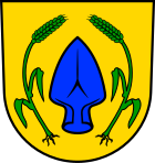
Blazon: In gold (yellow) a fallen blue ploughshare, accompanied on both sides by a rooted, curved green ear. The municipal flag has the colors green – yellow (green – gold).
The coat of arms, the figures of which refer to agriculture, goes back to a "stain sigil" from 1825. The coat of arms and flag were officially awarded by the Baden-Württemberg Ministry of the Interior on November 14, 1967.
Culture and sights
Museums
- Early history museum, established in 1998
- Working group on culture and history, founded in 2004
- Förderverein Heidengraben e. V., founded in 2005
Buildings
- The Protestant Church of St. Peter and Paul is a Romanesque choir tower church with a late Gothic nave and wall paintings from the first half of the 15th century. The frescoes were whitewashed during the Reformation and rediscovered between 1912 and 1924. Only a part could be restored. The mural depicts the Last Judgment. The Romanesque tower is adorned with a half-timbered bell house with a curved helmet and “lantern” from 1680. The church was renovated in 1935 by architect Hans Seytter and 1965–1971 by architect Johannes Wetzel . The color-glazed choir window with eight image fields (from the birth of Jesus to his resurrection) was designed in 1935 by the artist Walter Kohler .
- Hofen ruins , from the 13th century
- Burial mound
- The Heidengraben , the largest Celtic oppidum in Germany and one of the largest in Europe
societies
Sports
- Gymnastics and Sports Club Grabenstetten 1913 e. V.
- Motorsport Club Grabenstetten e. V., founded February 13, 1987
- Schützenverein Grabenstetten e. V.
- Fliegergruppe Grabenstetten-Teck-Lenninger Tal e. V.
music
- Gesangverein Liederkranz Grabenstetten e. V.
Others
- Fruit and horticultural association, founded in 1933
- Swabian Alb Association
- Working group cave and karst Grabenstetten e. V., founded in 1973
- Heidengraben Friends' Association, founded in 2005
- Grabenstetten youth club, founded in 2009
Natural monuments
The Falkensteiner Cave is located on the Albtrauf between Grabenstetten and Bad Urach. In 2019 it was awarded as a Geopoint of the UNESCO Geopark Swabian Alb . The approx. 5 km long cave is an active water cave, i. H. the precipitation seeps through the karst of the Alb plateau and gets out through the cave. The waters of the cave form the source of the Elsach .
The Gustav-Jakob-Höhle is an approx. 427 m long, predominantly horizontal through cave . It lies under the Hofen ruins.
Regular events
Kandelfescht: Street festival of the local clubs, usually on the second weekend in July every year.
Economy and Infrastructure
Industrial companies
Not far from the village is a large quarry with an attached gravel works. The Jurassic limes are mined for road gravel. The quarry was not expanded again until 2014 to the west, towards the town, by 9.8 hectares. The excavation depth is 85 m below the terrain surface.
traffic
The state road 211 connects the community in the west with Bad Urach and in the east with Lenningen .
The Public transport is by the Verkehrsverbund Neckar-Alb-Donau guaranteed (NALDO). The community is located at Wabe 221. The nearest train station is Oberlenningen , around 4 km away and in the VVS .
Grabenstetten has an airfield which is operated by the Fliegergruppe Grabenstetten-Teck-Lenninger Tal e. V. is operated.
education
Grabenstetten has its own elementary school, the Rulamanschule . Secondary schools are available in neighboring towns. For the youngest residents, there is a nursery school in a Protestant ownership.
Personalities
Sons and daughters of the church
- Wilhelm Christian Steeb (1788–1871), clerk in Pfullingen, member of the state assembly (state parliament)
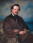
- David Friedrich Weinland (1829–1915), scientist and writer ( Rulaman )
Individual evidence
- ↑ State Statistical Office Baden-Württemberg - Population by nationality and gender on December 31, 2018 (CSV file) ( help on this ).
- ^ Website of the Evangelical Church Community of Grabenstetten
- ↑ http://www.staatsanzeiger.de/politik-und-verwaltung/nachrichten/wahlen/buergermeisterwahlen/grabenstetten/ ( page no longer available , search in web archives ) Info: The link was automatically marked as defective. Please check the link according to the instructions and then remove this notice. , http://www.gea.de/region+reutlingen/neckar+erms/amtseinsetzung+auf+in+die+zweite+runde.1807193.htm
- ↑ http://www.swp.de/muensingen/lokales/alb-neckar/geradlinig-und-kantig-13858955.html
- ↑ http://exchange.hirsch-woelfl.de/news/getFile.php?id=2272785&id2=392239&id3=26302&file=70070-1484561234-0.pdf
- ↑ Article "Moeck quarry wants to expand" at swp.de


