
Lichtenstein (Württemberg)
| coat of arms | Germany map | |
|---|---|---|

|
Coordinates: 48 ° 26 ' N , 9 ° 15' E |
|
| Basic data | ||
| State : | Baden-Württemberg | |
| Administrative region : | Tübingen | |
| County : | Reutlingen | |
| Height : | 507 m above sea level NHN | |
| Area : | 34.24 km 2 | |
| Residents: | 9239 (December 31, 2018) | |
| Population density : | 270 inhabitants per km 2 | |
| Postal code : | 72805 | |
| Area code : | 07129 | |
| License plate : | RT | |
| Community key : | 08 4 15 092 | |
| Community structure: | 3 districts | |
| Address of the municipal administration: |
Rathausplatz 17 72805 Lichtenstein |
|
| Website : | ||
| Mayor : | Peter Nussbaum ( independent ) | |
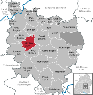
| Location of the municipality of Lichtenstein in the Reutlingen district | ||
  |
||

Lichtenstein is a municipality in Baden-Württemberg with 9190 inhabitants (as of June 30, 2017). It belongs to the Neckar-Alb region and the peripheral zone of the European metropolitan region of Stuttgart . It is located on the Albtrauf , the steep northern edge of the central Swabian Alb , about ten kilometers south of the district town of Reutlingen . The seat of the municipal administration is the Unterhausen district. Lichtenstein is part of the Swabian Alb biosphere area with 7.3% of its municipal area . The name of the community is derived from its most famous landmark, Lichtenstein Castle , located on a rocky promontory on the Albrand above the western flank of the upper Echaz valley .
geography
Geographical location
The districts of Honau and Unterhausen are in the valley of the Echaz , a 23-kilometer-long tributary of the Neckar that rises directly below the Albtrauf in Honau . In contrast, the eastern district of Holzelfingen with the somewhat remote hamlets of Göllesberg and the Traifelberg, which belongs to Honau, is already on the plateau of the Swabian Alb about 200 to 300 m higher. Holzelfingen and Traifelberg are connected to the largest district of Unterhausen by the Albaufstiege Holzelfinger Steige and Honauer Steige (passage of the federal highway 312 ). The most important touristic excursion destinations of the municipality, Lichtenstein Castle and the Nebelhöhle , located in the western part of the district, are also located in the hilly areas of the so-called Middle Kuppenalb on the Alb plateau , which are characterized by mixed forest . At the nearby Gießstein is the transmitter Unterhausen .
Neighboring communities
Lichtenstein is bordered by four communities that also belong to the Reutlingen district . The town of Pfullingen is located in the north, largely belonging to the Alb foreland ; the other neighboring communities are located on the Alb plateau: St. Johann in the east, Engstingen in the south and Sonnenbühl in the west .
Community structure
The three former communities of Holzelfingen , Honau and Unterhausen form the districts of the community of Lichtenstein. The two districts of Honau and Holzelfingen also form localities within the meaning of the Baden-Württemberg municipal code, each with its own local council and local mayor as its chairman.
The village of Holzelfingen with Greifenstein Castle is part of the Holzelfingen district . The Honau district includes the village of Honau, Lichtenstein Castle (Württemberg) and the Traifelberg housing estate located on the Albtrauf. The Unterhausen district includes the village of Unterhausen and the Göllesberg housing estate; the municipality of Oberhausen has merged into Unterhausen and was abolished in 1975.
In the district Holzelfingen lying Outbound Castle Heideck and Outbound homestead Traifelberg. In the district of Honau lies the deserted Feilenschmiede and in the district of Unterhausen are the abandoned castles Burgstein , Greifenstein , Stahleck and not secured Hochbidegg .
The height information and population of the districts in detail (height information: average height; population):
- Holzelfingen ( 700 m above sea level ) with 1282 inhabitants
- Honau ( 565 m above sea level ) with 1026 inhabitants
- Unterhausen ( 507 m above sea level ) with 6882 inhabitants
history


From prehistory to the high Middle Ages
Archaeological evidence of Alemannic settlements was found in both Honau and Holzelfingen . Furthermore, finds of Roman utensils in the Honau district indicate that the area of today's Lichtenstein could have been on a Roman road in antiquity .
During the rule of the Franks in the Middle Ages, the places in what is now the municipality were part of the Pfullichgau of the Duchy of Swabia .
First evidence and developments of the localities
The name Holzelfingen probably goes back to the old first name Holzulf . The first mention as Holtelvingen was in 1220. At that time the Greifenstein Castle (now in ruins) inhabited by the Lords of Greifenstein that the reputation of the passage of time robber barons were increasingly feared by the rural population and hated. After the neighboring noble family, the Lords of Lichtenstein , had been defeated by the troops of Count Eberhard of Württemberg during the Imperial War in 1311 , Ritter Schwigger, the last known member of the Lords of Greifenstein, sold his estate, including Holzelfingen, to Württemberg in 1355.
Earlier than the neighboring communities, Honau fell to the House of Württemberg, first under the rule of the Counts of Achalm , always beset by the aristocratic houses in the area, the Lichtensteiners and the Greifensteiners.
Until the beginning of the 19th century, the places were subordinate to the Protestant monastery office Pfullingen of the Duchy of Württemberg since 1534 .
During the Thirty Years' War between 1618 and 1648, all the villages in what is now Lichtenstein's district were plundered and plundered several times by the Soldateska of the Landsknechts troops passing through.
From the 19th century to the present
The four old Württemberg towns of Holzelfingen and Honau as well as Oberhausen and Unterhausen were subordinated to the Oberamt Reutlingen following the establishment of the Kingdom of Württemberg in 1806 as part of the new administrative structure . In 1892 and 1893, the opening of the Echaz Valley Railway brought the connection to the route network of the Württemberg State Railways .
As early as 1930, the town of Oberhausen was incorporated into the community of Unterhausen. The administrative reform during the Nazi era in Württemberg led to membership in the Reutlingen district in 1938 .
After the Second World War, the villages fell into the French occupation zone and thus came to the newly founded state of Württemberg-Hohenzollern , which was incorporated into the state of Baden-Württemberg in 1952.
Incorporations
On January 1, 1975, the communities Holzelfingen and Honau were incorporated into Unterhausen. The community was renamed Lichtenstein.
Naming
The municipality of Lichtenstein was named after Lichtenstein Castle , which towers above the upper Echaztal and was built in the early 1840s according to the ideas of a medieval castle at the time, commissioned by Count Wilhelm von Württemberg (later Duke of Urach). The inspiration for this building in the Romantic style was provided by the historical novel Lichtenstein by Wilhelm Hauff , who in turn was modeled on the former Lichtenstein Castle , which was built between 1150 and 1200 by the Lichtenstein family, which died out in the late Middle Ages; - a castle that was destroyed by the troops of the free imperial city of Reutlingen during the Swabian city war at the end of the 14th century and then fell apart. The remains of the ruin are now only a few hundred meters southeast of the location of the current castle.
Religious communities
Protestant church
Since the Reformation in Württemberg in 1534, the villages were evangelical. On the one hand, there is currently the Protestant overall parish of Unterhausen-Honau. This Protestant parish has three historic churches. The Johanneskirche , whose beginnings date back to the 10th century, is located in the Unterhausen district. In the former Oberhausen district, the Erlöserkirche and the Gallus Church in Honau are used as places for worship. Two parish halls and a kindergarten also belong to the overall parish. On the other hand, a separate parish is the Protestant parish of Holzelfingen around the St. Blasius Church , whose pastor also serves the St. Johann suburb of Ohnastetten . The parishes belong to the Reutlingen church district in the Evangelical Regional Church .
Methodist Church
The Evangelical Methodist Church is present in Lichtenstein through three local parishes, which are looked after by a pastoral office. The churches of the Free Church are located in Unterhausen on Friedhofweg, in Honau on Heerstraße and in Holzelfingen on Honauer Straße.
Catholic Church
For the Catholics there is the branch church of St. Brother Konrad in Unterhausen, which is looked after by the Pfullingen parish in the pastoral care unit Echaztal , and which covers all three sub-towns of Lichtenstein. This Roman Catholic community was established in 1926 and got its own church in 1935, the St. Konrad Church . It belongs to the Reutlingen-Zwiefalten deanery of the Rottenburg-Stuttgart diocese . The Catholic community also has a kindergarten.
New Apostolic Church
The New Apostolic parish meets for divine service in its parish center on Friedenstrasse in Unterhausen. It belongs to the New Apostolic church district of Reutlingen.
politics
Municipal council
In Lichtenstein, the municipal council is elected using the spurious sub-district election. The number of local councils can change due to overhang mandates . After the last election, the municipal council in Lichtenstein has 22 members (previously: 19). The local elections on May 26, 2019 led to the following preliminary final result. The municipal council consists of the elected voluntary councilors and the mayor as chairman. The mayor is entitled to vote in the municipal council.
| Parties and constituencies |
% 2019 |
Seats 2019 |
% 2014 |
Seats 2014 |
% 2009 |
Seats 2009 |
||
| FW | Free electoral association | 29.3 | 6th | 29.4 | 6th | 29.2 | 6th | |
| CDU | Christian Democratic Union of Germany | 27.4 | 6th | 31.6 | 6th | 38.8 | 9 | |
| SPD | Social Democratic Party of Germany | 22.3 | 5 | 21.5 | 4th | 17.8 | 4th | |
| OGL | Open green list | 20.9 | 5 | 17.4 | 3 | 14.2 | 3 | |
| total | 100.0 | 22nd | 100.0 | 19th | 100.0 | 22nd | ||
| voter turnout | 54.5% | 44.3% | 48.6% | |||||
The local councils of Holzelfingen and Honau each consist of nine members.
mayor
- 1975–1987: Ernst Braun (independent)
- 1987–2011: Helmut Knorr (CDU)
- since 2011: Peter Nussbaum (independent)
The mayor is elected for an eight-year term. The third and last term of office of Helmut Knorr ended on January 2, 2011. On January 13, 2011, the non-party graduate administration specialist Peter Nussbaum, who voted against the incumbent in the mayoral election on October 24, 2010 with 62.1% of the votes cast Knorr (26.7%) and two other candidates had prevailed in the first ballot when they were sworn in as Lichtenstein's mayor.
Town twinning
![]() Voreppe , France (since 1992)
Voreppe , France (since 1992)
coat of arms
Coats of arms of the sub-municipalities:
 Holzelfingen |
 Honau |
 Unterhausen |
|---|
Coat of arms of the former municipality of Oberhausen (incorporated into Unterhausen in 1930):
 Oberhausen |
|---|
Culture and tourist peculiarities


Historical buildings
- Saint Blasius Church in Holzelfingen
-
Lichtenstein Castle
- Not far from there are the Alt-Lichtenstein castle ruins
- Johanneskirche in Unterhausen with its frescoes
- Greifenstein castle ruins
- Cultural monument (former) Honau train station
- See also Honau – Lichtenstein rack railway
- Gallus Church in Honau
- Church of the Redeemer in Unterhausen (formerly Oberhausen)
- Karl Bröger School (originally "Herbert Norkus School")
Museums
- Wilhelm Hauff Museum in Honau
- Mimus Mineral Museum in Unterhausen
Natural monuments
- Nebelhöhle (830 m length)
- Olga cave (125 m long)
- Gold hole
- Echaz spring (near Honau)
- Brick well (formation of tuff)
Regular events
- New Year's Day: New Year handball tournament
- April 30th: Rock beer festival in Honau
- May 1st: Bock beer festival in Honau
- Ascension Day: Göllesbergfest and Olgahöhlenfest
- Pentecost: Fog Cave Festival
- Between Whitsun and the summer holidays: Lichtenstein children's and youth campaign day
- Beginning of July (every 2 years): Street festival at the Echaz - "Goas-Garda" festival
- First Friday in the summer holidays: Beach party in the Honau outdoor pool
- Last week of summer vacation: Children's Bible Week
- October fire service and Bavarian breakfast of the volunteer fire brigade in Unterhausen
- Second Advent weekend: Lichtenstein Christmas market around the Honau train station.
Sports
- Traifelberg ski lift
- Winter sports arena Holzelfingen
- Lichtenstein trail
Economy and Infrastructure
Businesses and businesses
Economically, the community is characterized by medium-sized small and craft businesses. On the grounds of the Unterhausen (BSU) cotton spinning mill, which was closed in 1993 and which has been the municipality's largest industrial company with up to 380 employees for over 140 years, on the northern border of Lichtenstein, there is now an industrial park with branches of various small companies. The largest industrial company in Lichtenstein with around 200 employees is Baumann GmbH at the southern end of Unterhausen as the German branch of the Swiss company Baumann Federn AG . Otherwise heard Lichtenstein infrastructure especially for the catchment area of Greater Stuttgart , especially Reutlingen.
Land use
In particular on the Alb plateau, a relevant agricultural and forestry use of part of the municipal area is of economic and structural importance.
In the district of Honau, which has a national tourist attraction value due to the proximity of the Lichtenstein Castle, there is a regionally relatively well-known brook trout farm, which belongs to a local hotel and restaurant, where the trout is prepared in various ways as culinary Specialty applies.
traffic

The B 312 runs through the community along the Echaz valley through the districts of Unterhausen and Honau to the Alb plateau (Honauer Steige). The state road L 387 branches off from this in Unterhausen and opens up the district of Holzelfingen (Holzelfinger Steige). The L 230 connects the communities of Lichtenstein and Sonnenbühl.
The Public transport is by the Verkehrsverbund Neckar-Alb-Donau guaranteed (NALDO). The community is located at Wabe 223. Bus routes to Reutlingen , Münsingen or Gammertingen run through the community . The Honau – Lichtenstein cogwheel section of the Reutlingen – Schelklingen railway line was dismantled as early as 1969 .
Personalities
Sons and daughters of the church
- Karl von Camerer (1801–1863), born in Unterhausen, lawyer, member of the state parliament
- Johann Georg Fetzer (1845–1909), Baptist theologian
- Karl Gero von Urach (1899–1981), head of the House of Urach
- Emil Kübler (1909–1981), composer and church musician
- Rainer Höh (* 1955), adventurer, translator and travel writer
- Torsten Traub (* 1975), soccer player
Web links
Individual evidence
- ↑ State Statistical Office Baden-Württemberg - Population by nationality and gender on December 31, 2018 (CSV file) ( help on this ).
- ^ The state of Baden-Württemberg. Official description by district and municipality. Volume VII: Tübingen administrative region. Kohlhammer, Stuttgart 1978, ISBN 3-17-004807-4 . Pp. 35-38
- ^ Municipality of Lichtenstein - numbers-data-facts. In: gemeinde-lichtenstein.de. June 30, 2017. Retrieved November 9, 2017 .
- ^ Federal Statistical Office (ed.): Historical municipality directory for the Federal Republic of Germany. Name, border and key number changes in municipalities, counties and administrative districts from May 27, 1970 to December 31, 1982 . W. Kohlhammer, Stuttgart / Mainz 1983, ISBN 3-17-003263-1 , p. 538 .
- ↑ Internet presence of the entire parish ( memento of the original from December 3, 2013 in the Internet Archive ) Info: The archive link was inserted automatically and has not yet been checked. Please check the original and archive link according to the instructions and then remove this notice. ; accessed on November 28, 2013
- ↑ Katholische Kirchengemeinde Lichtenstein ( Memento of the original from May 17, 2014 in the Internet Archive ) Info: The archive link was automatically inserted and not yet checked. Please check the original and archive link according to the instructions and then remove this notice. ; accessed on November 28, 2013
- ↑ New Apostolic Church District Reutlingen-Süd ; accessed on November 28, 2013
- ^ Official final result of the mayoral election in Lichtenstein on October 24, 2010
- ^ Website of the Johanneskirche in Unterhausen
- ^ Südwest Presse Online-Dienst GmbH: Lichtenstein: Festival on the "Goas-Garda" . In: swp.de . July 1, 2015 ( swp.de [accessed February 1, 2018]).
- ↑ cf. also Andrea Steudle: Winter sports on the Swabian Alb. The ski hut in Traifelberg (Lkr. Reutlingen). In: Preservation of monuments in Baden-Württemberg , 40th year 2011, issue 4, p. 243 f. ( PDF ( Memento of the original from December 22nd, 2014 in the Internet Archive ) Info: The archive link has been inserted automatically and has not yet been checked. Please check the original and archive link according to the instructions and then remove this note. )
- ↑ Presentation of Baumann GmbH with aerial photo of the company premises (bottom of the Baumann AG website)

Bad Urach | Dettingen on the Erms | Engstingen | Eningen under Achalm | Gomadingen | Grabenstetten | Grafenberg | Hayingen | Hohenstein | Pods | Lichtenstein | Mehrstetten | Metzingen | Münsingen | Pfronstetten | Pfullingen | Pliezhausen | Reutlingen | Riederich | Römerstein | St. Johann | Sonnenbühl | Trochtelfingen | Walddorfhäslach | Wannweil | Double folds
Manor district Münsingen (unincorporated area)