Sonnenbühl
| coat of arms | Germany map | |
|---|---|---|

|
Coordinates: 48 ° 23 ' N , 9 ° 11' E |
|
| Basic data | ||
| State : | Baden-Württemberg | |
| Administrative region : | Tübingen | |
| County : | Reutlingen | |
| Height : | 775 m above sea level NHN | |
| Area : | 61.26 km 2 | |
| Residents: | 7157 (December 31, 2018) | |
| Population density : | 117 inhabitants per km 2 | |
| Postal code : | 72820 | |
| Area code : | 07128 | |
| License plate : | RT | |
| Community key : | 08 4 15 091 | |
| LOCODE : | DE ONL | |
| Community structure: | 4 districts | |
| Address of the municipal administration: |
Main street 2 72820 Sonnenbühl |
|
| Website : | ||
| Mayor : | Uwe Morgenstern | |
| Location of the community of Sonnenbühl in the Reutlingen district | ||
Sonnenbühl is a municipality on the plateau of the Swabian Alb south of Reutlingen . The seat of the municipal administration is in the district of Undingen.
geography
Geographical location
Sonnenbühl is located on the northern edge of the Swabian Alb, on the so-called Middle Kuppenalb . The district of Genkingen ( 771 m above sea level ) extends to the Albtrauf . It lies at the top of the Wiesaztal . The Lauchert rises west of Willmandingen ( 751 m above sea level ) and the Erpf in the Erpfingen district ( 731 m above sea level ) , which flows into the Lauchert south of the village. The district of Undingen is 775 m above sea level. NN . The lowest point is at 645 m in the Seebachtal near Willmandingen, the highest at 880.8 m on the Bolberg .
geology
The near-surface geological subsurface of Sonnenbühl is characterized by the typical Alb rocks of the White Jura . The valley slopes are formed by the limestone marls of the White Jura alpha, the edge of the steps and the plateau of the Alb from the banked limestone of the White Jura betha. The plateau is partly overlaid by mighty weathered loam and clay. The Alb plateau near Sonnenbühl is overlooked by several peaks, which are formed by reef limestone of the White Jura delta and are carved out as hardling peaks. The Ruchberg, west of Willmandingen, is a prime example of such a knoll. The limestone of the White Jura is strongly karstified and shaped by karst forms such as caves , sinkholes and dry valleys .
Neighboring communities
The following cities and municipalities border on the municipality of Sonnenbühl, they are named starting clockwise in the north and belong to the district of Reutlingen or the Zollernalb district ¹ and the district of Tübingen .²
Pfullingen , Lichtenstein , Engstingen , Trochtelfingen , Burladingen ¹, Mössingen ² and Reutlingen .
Community structure
The municipality of Sonnenbühl consists of the four municipalities of Erpfingen, Genkingen, Undingen and Willmandingen, which were independent until 1974. In the four earlier municipalities, localities are set up within the meaning of the Baden-Württemberg municipal code, each with its own local council and local mayor as its chairman. See also Hohenerpfingen Castle (Schnatren) , Erpfingen Castle that has been removed
Only the villages of the same name belong to the districts of Undingen and Willmandingen. The Erpfingen part of the municipality includes the village of Erpfingen, the Dreherhof farmstead and the Erpfmühle and Pumpwerk houses, and the Genkingen part of the municipality includes the village of Genkingen and the Talmühle house.
In the east part of such Erpfingen lying Outbound location Weiler, whose name as a field name is preserved. Moreover, it was by excavations in 1969-70 Won Lower Wässere demonstrated a settlement. In the Undingen part of the municipality is the abandoned Hohengenkingen Castle and in the Willmandingen part of the municipality is the Seebachmühle, which was sold in 1846.
climate
In February 1978, the Erpfingen district was officially declared a climatic health resort .
history
Alemannic settlements probably existed in the municipality as early as the 3rd century. In the High Middle Ages the area belonged to the Duchy of Swabia .
Erpfingen
Erpfingen was mentioned for the first time in the Lorsch Codex on November 16, 777 when it was donated to the Lorsch Monastery as Erphinga . In the 14th and 15th centuries, the lords of Salmendingen, the taverns of Erpfingen and the counts of Werdenberg owned castles on site. From 1357 Fritz Remp von Pfullingen bought property from the Lords of Salmendingen in Erpfingen. From the middle of the 15th century, the influence of the county of Württemberg became increasingly important, until finally the entire village had become part of Württemberg. At the time of the Duchy of Württemberg, Erpfingen belonged to the Unteramt Willmandingen in the Amt Urach (or since 1758 Oberamt Urach ). In 1808 Erpfingen went over with the Willmandingen sub- office to the Reutlingen regional office .
Genkingen
Genkingen was first mentioned in 772 as Gancgingen also in a deed of donation from the Lorsch Codex. Since the Middle Ages, the village has belonged to the Lords of Genkingen, who maintained their castle ( Burg Genkingen ) there. They were mentioned several times in deeds of donation to the Zwiefalten monastery . Since 1506 it has belonged to the Pfullingen women's monastery and became Protestant and Wuerttemberg with this during the Reformation. The Wuerttemberg monastery office in Pfullingen, to which Genkingen has belonged since then, existed until 1806 and then went over as Unteramt Pfullingen to the Oberamt Reutlingen . The Unteramt Pfullingen was dissolved in 1818.
Absurdity
As early as 806, Undinga was owned by the St. Gallen monastery . In 1098, Count Luithold von Achalm donated it to the Zwiefalten monastery and in 1454 Undingen became part of Württemberg. The place belonged to the Unteramt Willmandingen in the Amt Urach (or since 1758 Oberamt Urach). In 1808, Undingen and the Willmandingen sub-office were transferred to the Reutlingen regional office.
Willmandingen
The name Willmandingen is on a document dated July 10, 772 from the St. Gallen monastery. In it, a certain Ruotah indicates that he is building a church in Willimundincas in honor of St. Gall and equipping it with goods and serfs. It probably comes from an Alemannic tribal leader Willimund from the 3rd century. In 1474, Count Eberhard von Württemberg bought the place. With that he came to the office of Urach. Willmandingen was the seat of a lower office until 1818, which was assigned to the Reutlingen upper office in 1808. The Willmandingen sub-office was dissolved in 1818, so that all places were then directly subordinate to the upper office.
Administrative affiliation since the 19th century
After the establishment of the Kingdom of Württemberg , in the course of the new administrative structure, all four places had become part of the Reutlingen Oberamt by 1808 at the latest , albeit in different subordinate offices until 1818. The administrative reform during the Nazi era in Württemberg led to membership in the Reutlingen district in 1938 . After the Second World War, the villages became part of the French zone of occupation and were thus assigned to the newly founded state of Württemberg-Hohenzollern , which was incorporated into the state of Baden-Württemberg in 1952.
Establishment of the Sonnenbühl community
The four previously independent municipalities of Erpfingen, Genkingen, Undingen and Willmandingen merged on January 1, 1975 as part of the municipal reform in Baden-Württemberg , initially under the name Undingen . Sonnenbühl was then chosen as the new community name .
politics
The district of Undingen is the administrative seat of the municipality.
Municipal council
In Sonnenbühl, the municipal council is elected using the spurious sub-district election. The number of local councils can change due to overhang mandates . The municipality council in Sonnenbühl has 19 members after the last election (2014: 21). The local election on May 26, 2019 led to the following official final result. The turnout was 62.6% (2009: 54.3%). The municipal council consists of the elected voluntary councilors and the mayor as chairman. The mayor is entitled to vote in the municipal council.
| Free electoral association | 8 seats | 42.2% | 2014: 10 seats, 49.8% |
| Sonnenbühler citizens | 7 seats | 36.7% | 2014: 6 seats, 26.9% |
| CDU | 4 seats | 21.1% | 2014: 5 seats, 23.3% |
mayor
The mayor is elected for an eight-year term. On July 12th, 2009 the incumbent mayor Gerrit Elser was elected as the new mayor of Giengen an der Brenz . Therefore, on October 11, 2009, a mayoral election took place in Sonnenbühl. Uwe Morgenstern was elected mayor with a clear majority (58.9%) in the first ballot. In the mayoral election on November 12, 2017, Morgenstern was the only applicant and was confirmed in office with 91.6% of the vote.
- Genkingen
- until 1908: Heinrich Schumacher
- 1909–1934: Johannes Ruoff
- 1934-1946: Alois Walker
- 1946–1950: Adolf Weinland
- 1950–1974: Ernst Herrmann
- Absurdity
- 1973–1975: Manfred Stierle
- Sonnenbühl
- 1975–1999: Dieter Winkler
- 1999–2009: Gerrit Elser
- Since 2010: Uwe Morgenstern
coat of arms
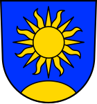
Coat of arms of the community of Sonnenbühl
The former independent districts had very different coats of arms of their own. Therefore, at the time of the merger, it was agreed to design a completely new coat of arms. This is formed from the two components of the community name. The blazon of the municipal coat of arms reads: "In blue over a golden (yellow) hill (Bühl) a golden (yellow) sun with 16 alternating straight and S-shaped curved golden (yellow) rays."
Coats of arms of the districts
 Erpfingen |
 Genkingen |
 Absurdity |
 Willmandingen |
|---|
Town twinning
The municipality of Sonnenbühl has been in partnership with the municipality of Corseul in France since 1987 .
Culture and sights
Museums
Germany's first Easter egg museum was set up in the Erpfingen district and inaugurated in February 1993. It shows over a thousand exhibits from all over Europe.
Sports
The rifle club "Bolberg" Willmandingen, or SV Willmandingen for short , was founded in 1961 and was represented with a team in the 1st Bundesliga air pistol in the South Group season .
In the Erpfingen district there has been a spa garden and a 1,300-meter-long summer bobsleigh run since 1992.
For golf enthusiasts there is an 18-hole golf course in Undingen .
In winter there are a large number of trails for ski hikers of various degrees of difficulty and lengths, in summer these are hiking routes.
tourism
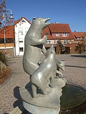
The Traumland amusement park on the Bear Cave is a magnet especially for families with small children.
Economy and Infrastructure
economy
The communal corridor is used intensively for both agriculture and forestry. Sonnenbühl is a year-round holiday destination. The tourist infrastructure therefore plays a special role. These include the Sonnenmatte holiday village , outdoor pool and campsite near Erpfingen, cycling, hiking and skiing trails as well as tourist attractions such as the show caves. A ski lift near Genkingen enables downhill skiing .
Limestone is quarried in quarries on the northern edge of Willmandingen and Genkingen. In Willmandingen, ground ore was also extracted in the past .
traffic
The community area is accessed in a north-south direction by state road 382 and in east-west direction by state road 230.
The Public transport is by the Verkehrsverbund Neckar-Alb-Donau guaranteed (NALDO). The community is located in honeycomb 223.
natural reserve
The Greuthau nature reserve lies between Lichtenstein Castle and the Nebelhöhle . The area is a vegetation mosaic made up of lime lawns , juniper heaths , oat meadows, groups of bushes, forest communities, willow beech and willow spruce. Today it is also used as a sheep pasture. The name of the area means "cleared forest".
Natural monuments
The main attractions of Sonnenbühl are probably the two large caves, the Bear Cave and the Nebelhöhle .
- The Karls- und Bärenhöhle belongs to the Erpfingen district and is 271 meters long. Part of it, the Karlshöhle , was discovered on May 30, 1834, the Bear Cave in 1949.
- The first part of the fog cave was discovered in 1517. In 1920, an even larger part was added, so that 450 meters of the cave are accessible today. It is located near the district of Genkingen, but is partly also on the Lichtenstein mark and is historically related to the nearby Lichtenstein Castle .
Personalities
Sons and daughters of the church
- Johann Ludwig Schneller (1820–1896), Protestant missionary and educator in Jerusalem (born in Erpfingen)
- Johann Martin Flad (1831–1915), Protestant missionary in the mission among the Falaschas in Abyssinia
- Christian Regelmann (1842–1920), cartographer, historian of Württemberg cartography
- Helmut Paulus (1900–1975), German poet and archivist (born in Genkingen)
- Heinz Schanz (1927–2003), painter
- Willi Betz (1927–2015), born in Undingen; Founder of the shipping and logistics company named after him, Willi Betz GmbH & Co. KG, with headquarters in Reutlingen
- Otwin Brucker (* 1940), Mayor of Pliezhausen 1966–2005, President of the Baden-Württemberg Municipal Council 1994–2005
- Willi Maier (* 1948), athlete, German champion and Olympic participant (1972 and 1976) in the 3000 m obstacle course (born in Undingen)
Web links
- Official website of the municipality , accessed on March 18, 2020
Individual evidence
- ↑ State Statistical Office Baden-Württemberg - Population by nationality and gender on December 31, 2018 (CSV file) ( help on this ).
- ↑ Sonnenbuehl.de - List of local councils , accessed on December 9, 2016
- ^ The state of Baden-Württemberg. Official description by district and municipality. Volume VII: Tübingen administrative region. Kohlhammer, Stuttgart 1978, ISBN 3-17-004807-4 . Pp. 73-76
- ↑ Minst, Karl Josef [transl.]: Lorscher Codex (Volume 5), Certificate 3640, November 16, 777 - Reg. 1362. In: Heidelberg historical stocks - digital. Heidelberg University Library, p. 234 , accessed on April 20, 2018 .
- ↑ Minst, Karl Josef [transl.]: Lorscher Codex (Volume 5), Document 3275, September 17, 772 - Reg. 806. In: Heidelberger historical stocks - digital. Heidelberg University Library, p. 137 , accessed on April 20, 2018 .
- ^ Document book of the Sanct Gallen Abbey, Part I, document number 66
- ^ Local council election Sonnenbühl 2019. Accessed on November 5, 2019 .
- ^ Municipality of Sonnenbühl (ed.): Election results of the mayoral election . In: Official Gazette of the community of Sonnenbühl . Vol. 56, No. 46, 2017, p. 5.
- ↑ Official website of the Ostereimuseum Sonnenbühl ( Memento from June 25, 2013 in the Internet Archive )
- ^ Website of the Nebelhöhle ( Memento from June 13, 2010 in the Internet Archive )
- ↑ Thomas de Marco: Willi Betz passed away . Schwäbisches Tagblatt , December 15, 2015.


