Münsingen manor district
| coat of arms | Germany map | |
|---|---|---|

|
Coordinates: 48 ° 25 ' N , 9 ° 32' E |
|
| Basic data | ||
| State : | Baden-Württemberg | |
| Administrative region : | Tübingen | |
| County : | Reutlingen | |
| Height : | 810 m above sea level NHN | |
| Area : | 64.63 km 2 | |
| Residents: | 0 (Dec 31, 2018) | |
| Population density : | 0 inhabitants per km 2 | |
| License plate : | RT | |
| Community key : | 08 4 15 971 | |
| Location of the community-free area Gutsgebiet Münsingen in the Reutlingen district | ||
The manor district of Münsingen in the Reutlingen district in Baden-Württemberg is a municipality-free area in the Swabian Alb . It was founded on October 1, 1942 and essentially comprises the former Münsingen military training area in Münsinger Hardt . Along with Rheinau, it is one of two uninhabited, community-free areas in Baden-Württemberg.
The Münsingen manor district was an inhabited community-free area until 2010. The inhabited areas were remunicipalised on January 1, 2011.
geography
Neighboring communities
The following towns and communities border the Münsingen manor district, they are named starting clockwise in the north and belong to the Reutlingen district ¹ and the Alb-Danube district ²: Römerstein ¹, Laichingen ², Heroldstatt ², Schelklingen ², Münsingen ¹ and Bad Urach ¹.
structure
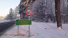
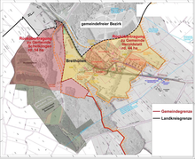
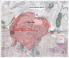
In the Münsingen manor district were the two places Barackenlager ( Altes Lager ) and Breithülen . On January 1, 2011, the old warehouse was incorporated into the city of Münsingen, and Breithülen was incorporated into the Heroldstatt community in the Alb-Donau district . The uninhabited former ammunition depot in Ingstetten, 56.3 hectares in size, was added to the city of Schelklingen on January 1, 2011.
Historical geography
In Gutsbezirk Münsingen more are Outbound places (now-defunct). Most of these places were closed with the establishment of the military training area in 1895 and its expansion in 1938. The first mention of Gruorn goes back to the first half of the 12th century. The community of Gruorn came to the military training area with the expansion of the military training area in 1938, the inhabitants of the village were resettled by 1939. The Hofgut Achenbuch, established in 1855, and the Ludwigshöhe manor, both of which were incorporated into the military training area in 1895, were located in the former district of Münsingen. The village of Bäumlersburg, which was built in 1843 and also came to the military training area in 1895, and the village of Heroldstatt, which was first mentioned in 1130 as a Heroluestetin, were located in the former Ennabeuren district . The village church was demolished at the beginning of the 19th century. Instead of the abandoned village, a courtyard was laid out in 1858, which was added to the military training area in 1895. Höcklingen, first mentioned around 1100 as Heggilingen , and Waldstetten, first mentioned in 1595 as uf Waldstetten, also belonged to the former Ennabeuren district. The Schorstallhof farm was located in the former Zainingen district.
Land use
According to the 2001 area survey, the total area of 66.98 km² was broken down as follows:
- Agricultural area: 48.61 km²
- Forest area: 16.90 km²
- Water area: 0.00 km²
- Settlement and traffic area: 1.47 km²
- Building and open space: 0.78 km²
- Traffic area: 0.68 km²
history
19th and 20th centuries
The Münsingen military training area was built in 1895 on the site of the so-called Münsinger Hardt by the Württemberg military administration . In 1897, the Remontedepot Breithülen (77 hectares) was set up on the southeast corner of the square , the task of which was to provide 250 horses a year for the Württemberg Army Corps . After the First World War , the depot was closed, but re-established in 1934 as part of the armament of the Wehrmacht .
In 1938 the Münsingen military training area was expanded. At that time, the entire district of the community Gruorn and parts of the neighboring communities Auingen, Böhringen, Böttingen, Ennabeuren, Feldstetten, Hengen, Ingstetten, Magolsheim, Münsingen, Seeburg, Trailfingen and Zainingen merged into it. For this purpose, the 665 residents of the community Gruorn had to be resettled after the resolution of the community was resolved in 1937. The resettlement took place between 1937 and 1939. The residents moved to various places in Württemberg, Baden and Bavaria.
When the community-free area Gutsgebiet Münsingen was established in 1942 , the employees of the depot were the first residents of this administrative district. After the end of the Second World War , the French occupying forces took over the military training area, half of which was also used by the Bundeswehr from 1957 .
On October 3, 1983, there was a shooting accident at the military training area: A mortar from Homeland Security Brigade 56 fired at a position that had not yet been cleared by a truck with observers. Two Bundeswehr soldiers were killed and 25 other soldiers and civilians were injured, some seriously.
In 1992 the French soldiers withdrew and left the entire area to the Bundeswehr.
21st century
On October 21, 2005, the military training area was decommissioned and handed over to the Federal Agency for Real Estate Tasks . The area is to remain federally owned, not least because large parts of it are contaminated by ordnance . The residential area "Königstraße" bordering on Auingen, the soldier settlement "Am Kapf" and the public residential area "Altes Lager" with an area of 96.3 hectares and 41 inhabitants were assigned to the city of Münsingen (Reutlingen district), the residential area "Breithülen" with 77 , 5 hectares and 64 inhabitants of the municipality of Heroldstatt (Alb-Danube district) and the former “Munitionsdepot Ingstetten” with 56.3 hectares of the municipality of Schelklingen (Alb-Donau district). The former soldiers' settlement "Am Kapf" has since been demolished by the city of Münsingen. This completed the remunicipalisation of the Münsingen military training area by the state of Baden-Württemberg in 2010. The district council of the Reutlingen district and the district council of the Alb-Donau district, the three affected communities, the Tübingen regional council, the Baden-Württemberg Ministry of the Interior and the Federal Agency for Real Estate Tasks have already changed the district and community boundaries and the associated area growth agreed. On December 15, 2010, the state parliament of Baden-Württemberg passed the law on the reorganization of the community-free area "Guts Bezirk Münsingen".
On January 1, 2011, the remunicipalisation of the inhabited areas of the Münsingen manor was finally completed. After 68 years the community-free period for Breithülen and for the residential areas mentioned above and bordering Auingen ended. The uninhabited military training area of 6,473 hectares in the former manor district with the abandoned village of Gruorn is now under the direct administration of the Reutlingen district as an uninhabited community-free area. It will also be necessary to reclassify the state electoral districts of Hechingen-Münsingen (61) and Ehingen (65) as well as the federal electoral districts of Reutlingen (289) and Ulm (292), as the residents of Breithülen belong to the Alb-Danube district and thus to the state electoral district of Ehingen and change to the federal constituency of Ulm. The residential areas "Königstrasse", "Am Kapf" and the public residential area "Altes Lager" remained in the state constituency of Hechingen-Münsingen and in the federal constituency of Reutlingen. After more than 70 years, the residents of the remunicipalized residential areas are again allowed to vote in mayor and local council elections in the respective communities. In addition, when it was incorporated into Heroldstatt, Breithülen received the new postcode 72535 and in return gave the postcode 72525 of Münsingen.
The Münsingen manor district is a central part of the Swabian Alb biosphere area . The former restricted area has been open to the public on designated paths since April 2006. Precisely marked and yellow marked routes have been opened for hikers, cyclists and inline skaters, and most of this network of trails is paved. For nature conservation reasons and because of the existing explosive ordnance, these paths must not be left on your own; fines of up to 50,000 euros are threatened for violations . From April 1st to November 1st, however, there is the possibility of taking part in a guided excursion to get to know the landscape and the flora and fauna better in safe places away from the main paths. These tours are led by fully trained and trained military training area guides (TrÜP guides). For hikers, the TrÜP guides offer three different routes that lead to the north-east, north-west or south-east of the 6700 hectare area. There is also the option of taking a bike or bus tour with a TrÜP guide on the area's public paths. The church tour in Gruorn and a visit to the old camp in Münsingen are also possible on request.
The information center for the Swabian Alb biosphere area, the offices of the biosphere area and the Geopark Schwäbische Alb e. V. already have their headquarters there. There was a riding stables in the Remonte depot in Breithülen; a shoe factory has been located there since November 2011.
The 38 km long Panzerringstrasse, built in the 1980s, is a private road and closed to visitors to the former military training area. This concreted circuit, about 10 meters wide (as well as the former driving school area between Böttingen and Magolsheim) is leased and is used by various companies such as B. Liebherr and Daimler used for test and demonstration drives in the low speed range.
Population development
These are population numbers according to the respective territorial status. The numbers are census results (¹) or official updates from the Baden-Württemberg State Statistical Office (only main residences ).
|
|
politics
In administrative terms, the Münsingen manor district was until December 31, 2009 a regional body within the meaning of the municipal code for Baden-Württemberg and in this respect comparable to the other municipalities of Baden-Württemberg. However, the manor district had no municipal council ( municipal council ) and no mayor . The population entitled to vote could only participate in federal elections , in the state of Baden-Württemberg and in the district of Reutlingen.
Manor district head and managing director
As head of the community-free area, instead of a mayor , the head of the manor was not elected, but was appointed as a civil servant by the Stuttgart regional finance office. This in turn was subordinate to a manager who took care of the community tasks.
District chairman since 1946
- 1946–1975: Friedrich Schock
- 1975–1980: Adam Fleischmann
- 1980–1982: Günther Miller
- 1982-2010: Horst Medrow
Managing director since 1946
- 1946–1976: Paul Früh
- 1976–2010: Willi Börgmann
Referendum
On September 26, 2010, a non-binding referendum took place in the Münsingen manor district, in which the future membership of the residents of the manor district was decided.
Culture and sights

graveyards
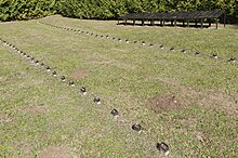
There are three freely accessible cemeteries on the site of the former military training area: the Hörnle cemetery, the Gänsewag forest cemetery and the cemetery at the Stephanuskirche.
The Hörnle cemetery is right next to the old warehouse; The best way to get there is via the southern entrance to path no.1. Not only were German soldiers and training site staff buried there, but also the fallen of two foreign units that had been set up in Münsingen after the start of World War II, namely the Italian Monte Division Rosa from 1943/44 and the Russian Liberation Army General Vlasov from 1944/45.
The Gänsewag forest cemetery is a few hundred meters further north on path no. 4. This is where mainly Russian soldiers from the First World War from the Gänsewag prisoner of war camp were buried. There is also a mass grave here for Soviet prisoners who died under inhumane conditions in the winter of 1941/42. Forced laborers and prisoners of war from the region were also buried here. A memorial stone with a Cyrillic inscription commemorates 542 unknown dead.
Another cemetery is located at the Stephanuskirche in the former village of Gruorn. The Committee for the Preservation of the Church in Gruorn e. V. looks after the old graves.
Buildings
![]() Map with all coordinates: OSM | WikiMap
Map with all coordinates: OSM | WikiMap
The Swabian Albverein has taken four observation towers after the closure of the training area, including three in 1981 erected steel lattice towers, which were originally removed. After renovation work, they were released in April 2007 as observation towers . At 42 m, the Hursch Tower is the highest of the three steel lattice structures and is located southwest of Zainingen on the Hursch at an altitude of 853 m above sea level. NN . The Waldgreutturm southeast of Zainingen is 20 m ( 864 m above sea level ), the Heroldstatt tower west of Ennabeuren 30 m ( 810 m above sea level ). The fourth tower on the Sternenberg near Böttingen is a former mill, only 8 m high ( 836 m above sea level ) and only open at times. In 2016, the Swabian Alb Association returned this tower to the Federal Agency for Real Estate Tasks , which has since been looked after by its Federal Forests division . When the weather is clear, the Alps can occasionally be seen from all towers , and the Ulm Minster (by Hursch and Waldgreut) or the Stuttgart TV tower (by Hursch) can also be seen at times .
There are also five other stone observation towers on the site, which - like several stone or concrete observation bunkers - are fenced in for security reasons and are therefore not accessible to the public. Some of the old observation bunkers now serve as a retreat for bats.
literature
- Joachim Lenk: Former military training area Münsingen. Leisure and hiking map . 2nd Edition. Wiedemann Verlag, Münsingen 2020, ISBN 978-3-9810687-6-4 (1 card, multicolored, 74 × 50 cm, folded).
- Iris Fromm-Kaupp: The Münsingen military training area. 110 years of military history in Württemberg. In: Denkmalpflege in Baden-Württemberg , Volume 37, 2008, Issue 3, pp. 159–164 ( denkmalpflege-bw.de PDF).
- Joachim Lenk: Last roll call in Swabian Siberia: Military in Münsingen, Breithülen and Feldstetten from 1895 to 2007 . 1st edition. Wiedemann Verlag, Münsingen 2008, ISBN 978-3-9805531-9-3 (158 pages).
- Günter Künkele : Natural heritage military training area - The Münsinger Hardt. Pictures of a unique landscape. Silberburg-Verlag, Tübingen 2006, ISBN 3-87407-713-6 .
- Joachim Lenk: From the snowshoe company to the tank battalion: Münsinger soldiers' life 1915 to 2004 . New warehouse, Herzog-Albrecht-Kaserne. 1st edition. Wiedemann Verlag, Münsingen 2004, ISBN 3-9805531-8-3 .
- Sönke Lorenz , Roland Deigendesch: From the commercial forest to the military training area - The Münsinger Hart. Writings on Southwest German regional studies, DRW-Verlag, Leinfelden-Echterdingen 1998, ISBN 3-87181-422-9 .
- Erich Schraml: 100 years of Münsingen military training area 1895–1995; a documentation. Baader, Münsingen 1995, ISBN 3-88287-011-7 .
Individual evidence
- ↑ State Statistical Office Baden-Württemberg - Population by nationality and gender on December 31, 2018 (CSV file) ( help on this ).
- ^ The state of Baden-Württemberg. Official description by district and municipality. Volume VII: Tübingen administrative region. Kohlhammer, Stuttgart 1978, ISBN 3-17-004807-4 , pp. 98-100.
- ^ The district of Reutlingen, Volume II , ISBN 3-7995-1357-4 , p. 1010.
- ↑ Gunfire accident of the German Armed Forces on October 3rd, 1983 ( page no longer available , search in web archives ) Info: The link was automatically marked as defective. Please check the link according to the instructions and then remove this notice.
- ↑ Law on the reorganization of the community-free area "Guts Bezirk Münsingen" ( Memento of the original of April 13, 2014 in the Internet Archive ) Info: The archive link was inserted automatically and has not yet been checked. Please check the original and archive link according to the instructions and then remove this notice. (PDF file; 35 kB) State Parliament of Baden-Württemberg (14th electoral period) - Printed matter 14/7384.
- ↑ StBA: Area changes from January 1st to December 31st, 2011
- ↑ SPIEGEL Online from September 17, 2012 - Former military training area Münsingen: Nature with duds
- ↑ Legal ordinance of the Tübingen regional council and the Reutlingen district office restricting access to the Münsingen military training area (Reutlingen district) of April 4, 2006 (PDF file; 18 kB).
- ↑ Referendum in Münsingen - which flag is hoisted? Stuttgarter Zeitung online, September 25, 2010.
- ↑ Hursch tower - information of the Schwäbischen Albverein , coordinates: 48 ° 28 '14.2 " N , 9 ° 31' 49.4" O .
- ↑ Waldgreutturm - information of the Schwäbischen Albverein , coordinates: 48 ° 28 '16.4 " N , 9 ° 34' 1.6" O .
- ↑ Heroldstatt tower - information of the Schwäbischen Albverein , coordinates: 48 ° 26 '48 " N , 9 ° 37' 27.8" O .
- ↑ Sternberg tower - information of the Schwäbischen Albverein , coordinates: 48 ° 24 '49.6 " N , 9 ° 33' 22" O .
- ↑ swp.de
- ↑ SWR2 Knowledge Zone of Life and Death - The former Münsingen military training area (PDF; 53 kB).
Web links
- alteslagermuseum.com , information about the Münsingen military training area and the old Münsingen camp
- garnisonstadt.de , information about the Münsingen military training area and the Herzog-Albrecht-Kaserne
- gruorn.de , information about the abandoned village of Gruorn
- breithülen.de Information about Breithülen
- A curiosity - The Gutsbezirk Münsingen , Reutlingen County


