
Gruorn


Gruorn is at Münsingen preferred Wüstung on the Schwäbischen Alb in Baden-Württemberg . It lies at an altitude of 790 meters above sea level in the Münsinger Hardt and is part of the Münsingen manor district .
history
Gruorn was first mentioned around 1095 and originally belonged to the Urach Oberamt, called Urach District from 1934 . In 1861 there were 469 residents in the village - all of them were Protestant . Even before the Urach district was divided up in 1938, the decision was made on February 15, 1937 to include the entire Gruorn area in the Münsingen military training area, which had existed since 1896 , in order to be able to expand it as planned. In 1938 Gruorn came to the Münsingen district for a short time , but the following year the 665 residents were forcibly relocated. In May 1939 the village was largely cleared - this made Gruorn famous far beyond the borders of the Swabian Alb. The area around Gruorn has belonged to the then newly created Münsingen manor district since April 10, 1942 and is therefore a so-called community-free area .
After the depopulation, the village buildings served as a backdrop for house-to-house fighting exercises and were left to decay. “After 1953, the French command office released the building for material removal, entire houses were completely demolished and rebuilt in another location. Gruorn continued to deteriorate. For security reasons, the buildings had to be torn down to the foundations by the military administration after 1972. "
Only the Stephanus Church with the attached cemetery and the war memorial , the new schoolhouse from 1881 and a few other foundation walls have been preserved and are still reminiscent of the village of Gruorn. Regular services have been held there once a year at Pentecost since 1968 ; later the former residents were allowed to return to Gruorn on All Saints' Day . In the years 1971 to 1973 the committee for the preservation of the church in Gruorn succeeded in rebuilding the church , which had fallen into disrepair over the years; the old graves are also tended by the members of the association. The Protestant Stephanuskirche in today's church district Bad Urach-Münsingen of the Evangelical State Church in Württemberg was first mentioned in 1095. Frescoes from 1380 (whitewashed in 1540) were uncovered as early as 1903. Above all, the design of the ten expressive church windows with glass paintings by Ursula Nollau characterizes the barren church interior. The northern choir window, in particular, illustrates the historical connections that affect Gruorn with the quote from the Bible: How is the city so desolate that was full of people! This is how the lamentations of Jeremiah begin ( Klgl 1,1 LUT ), in which the destruction of Jerusalem and the temple (around 586 BC) is sung about. - The Kreuzkantor Rudolf Mauersberger (1889–1971) composed the mourning motets created afterwards under the impressions of the destruction of Dresden in the Second World War for the Dresden Kreuzchor, an à cappella work, composed on Good Friday and Saturday in 1945. In it Mauersberger processed the disturbing him Experience of burning Dresden and the completely destroyed city; he took the text from the Lamentations of Jeremiah. First performance in the burned-out Kreuzkirchen ruin in Dresden on August 4, 1945. With these window designs, the Stephanuskirche Gruorn is a memorial against war and destruction.
After the dissolution of the Münsingen military training area, the Münsingen manor district and thus also the former village of Gruorn have been open to the public again since April 13, 2006 - after almost 67 years. A 35-kilometer network of trails has been released, on which Gruorn can also be reached from different directions. The remains of ordnance were removed in the area of the cleared paths; they can be used on foot or by bicycle. The former Gruorn school house now houses an exhibition on the history of the village as well as a small restaurant called Heimatstube with an attached beer garden. Furthermore, the former village and its surroundings have been part of the newly established Swabian Alb biosphere area since March 2008 .
Road network
Gruorn was originally connected to the regional road network from three sides. In addition to the connections that still exist today from the direction of Münsingen or Trailfingen on the one hand and from the direction of Zainingen on the other, there was originally a third access road from the direction of Seeburg . This Alb ascent branched off about two kilometers northwest of Seeburg from today's state road 245 to Hengen and is called Gruorner Straße in the local area from Seeburg to this day . There is also a Gruorn path in both Münsingen and Zainingen .
In addition, there is a Gruorner Straße in Ehingen (Danube), about thirty kilometers away , which, however, has no geographical connection with the eponymous place. However, it is located in a district of Ehingen, in which many former Gruorn citizens have found a new home after the forced relocation.
Son of the former parish
- Friedrich von Schindler (1827–1900), Oberamtmann of Württemberg and collegial director
gallery

Stephanuskirche and cemetery

Weathercock and clock tower, Stephanuskirche

Frescoes from around 1380, St. Stephen's Church

War memorial in the cemetery

Former school house
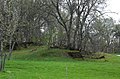
Foundation walls of a former building

A concrete structure built for military training purposes
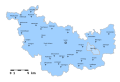
Location of Gruorn in the Oberamt Urach, territorial status at the beginning of the 19th century
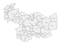
The district of Gruorn and its neighboring communities around 1860

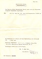
Takeover protocol of a piece of arable land in the Gruorn district in 1938 by the Reichsumsiedelungsges.
Announcement of the takeover of the arable land by the German Reich


literature
- Angelika Bischoff-Luithlen (Ed.): Gruorn - A village and its end. Baader, Münsingen 1986, ISBN 3-88287-003-6 .
Web links
- www.gruorn.info - Website of the Committee for the Preservation of the Church in Gruorn
- Gruorn and the Münsingen military training area - historical treatise
- Main State Archives Stuttgart - On the history of the community Gruorn
Coordinates: 48 ° 26 ′ 57.7 " N , 9 ° 30 ′ 13.7" E
Individual evidence
- ^ Ludwig Karl Schmidt: History of the Counts of Zollern-Hohenberg and their county , Stuttgart 1862; S. IIf.
- ↑ Information board Welcome to Gruorn! at the entrance to the Gruorn desert, read on July 16, 2017
- ↑ Brochure: The church windows of the Stephanuskirche in Gruorn ; published by the Committee for the Preservation of the Church in Gruorn eV, Münsingen 2013
- ↑ Nollau catalog raisonné see [1] - last accessed on June 7, 2020
- ↑ Andreas Steidel: The miracle of Gruorn ; in: Ev. Municipal Gazette for Württemberg, No. 24/2018, page 30 f