
Schupfart
| Schupfart | |
|---|---|
 |
|
| State : |
|
| Canton : |
|
| District : | Rheinfelden |
| BFS no. : | 4259 |
| Postal code : | 4325 |
| Coordinates : | 639683 / 262 661 |
| Height : | 446 m above sea level M. |
| Height range : | 401–750 m above sea level M. |
| Area : | 7.05 km² |
| Residents: | 798 (December 31, 2019) |
| Population density : | 113 inhabitants per km² |
|
Proportion of foreigners : (residents without citizenship ) |
13.5% (December 31, 2019) |
| Website: | www.schupfart.ch |
 Village center |
|
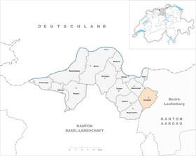
| Location of the municipality | |
  |
|
Schupfart ( Swiss German : ˈʃʊpfəɾt ) is a municipality in the Swiss canton of Aargau . It belongs to the Rheinfelden district and is located in the center of the Fricktal region , a little more than three kilometers south of the border with Germany .
geography
The clustered village is located in a shallow hollow at the upper end of the Fischingertal . The extensive plateaus of the Eikerberg ( 504 m above sea level ) and the Hellikerberg ( 541 m above sea level ) extend in the northern and western parts of the municipality through which the Fischingerbach flows . In contrast to the lower part of the Fischingertal, the transition to the plateaus is slightly uphill. The climbs to Wolberg ( 556 m above sea level ) in the east and in particular to Thiersteinberg ( 749 m above sea level ) in the south are, however, extremely steep in places. North of Schupfart, in the Eikerberg area, lies the geographical center of the Fricktal .
The area of the municipality is 705 hectares , of which 233 hectares are forested and 54 hectares are built over. The highest point is at 749 meters on the edge of the Thiersteinberg, the lowest at 408 meters on the Fischingerbach. The municipality of Schupfart is part of the Aargau Jura Park, a “Regional Nature Park of National Importance”. Neighboring communities are Münchwilen and Eiken in the north, Frick in the northeast, Gipf-Oberfrick in the southeast, Wegenstetten in the southwest, Hellikon in the west and Obermumpf in the northwest.
history
The oldest evidence of settlement in the municipality is a Celtic barrow from the Hallstatt period . On the border with Wegenstetten stood a simple manor built by the Romans . Rich finds of objects indicate a use from about 100 to 200 AD. In 2004, during excavations on the Herrain, a weir system ( Motte ) from the 11th century came to light, which is associated with the Lords of Homberg-Thierstein . Schuphart was first mentioned in a document in 1259. The place name comes from the Old High German scupfahard and means "pasture forest area surrounded by protruding terrain".
Around 1270 Schupfart came into the possession of the Counts of Habsburg-Laufenburg . From 1386 the Habsburgs ruled , who pledged the entire Fricktal to Burgundy after the Waldshut War of 1468 . When the Burgundians were defeated by the Confederates during the Burgundian Wars , Schupfart came back under Austrian rule in 1477. As a result of the imperial reform of the Austrian Emperor Maximilian I , Schupfart belonged to Upper Austria from 1491 and was located in the Fricktal region, a subordinate administrative unit of the Rheinfelden cameramen (from 1752 in the Upper Office Breisgau ). The most important landowners were the parish of Schupfart, the Canons' Monastery and the Johanniterkommende Rheinfelden , the Teutonic Order House in Beuggen and the women's monastery in Säckingen .

In the 17th century the village was hit by many blows of fate. In a plague epidemic in 1611, 95 of the 174 villagers at that time died. The Rappenkrieg , a peasant uprising, lasted from 1612 to 1614. The Thirty Years War , which also affected the Fricktal between 1633 and 1638, threw the village back in its economic development. Foreign troops also moved through the region during the War of the Palatinate Succession (1688–1697). In 1797 the Fricktal became a French protectorate after the Peace of Campo Formio . During the Second Coalition War , the front line between the armies of France and Austria ran here . A major fire caused by the negligence of French soldiers destroyed twelve houses on June 13, 1800. On February 20, 1802, Schupfart became a municipality in the Frick district of the Fricktal canton , which joined the Helvetic Republic in August . The municipality has belonged to the canton of Aargau since February 19, 1803.
Bad harvests and phylloxera epidemics led to a wave of emigration in the second half of the 19th century. Between 1850 and 1910 the population decreased by almost a quarter. This was followed by a slight but constant increase, and from the 1960s the village gradually changed from a farming community to a residential community. Since the beginning of the 1980s, the population has increased by over fifty percent thanks to the attractive residential area.
coat of arms
The blazon of the municipal coat of arms reads: "In white, green linden leaf." The linden leaf is taken from the seal of the Vogtamt Frick of the Counts of Homburg-Tierstein and first appeared on the community seal in 1872. The canton of Fricktal had this coat of arms between 1802 and 1803 .
Attractions
The development along the main road is extremely compact; it consists of eaves-standing multi-purpose buildings from the late 18th and 19th centuries with continuous gable roofs. The history of the Roman Catholic parish church of St. Leodegar goes back to the second half of the 10th century. The current church building was built between 1795 and 1797 in a classical style. In the niche of a house by the statue of Obermumpfer there is a late baroque statue of St. John Nepomuk from the early 18th century, around one meter high .

Village center, bus stop
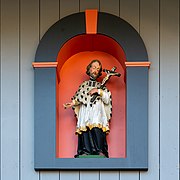
Late baroque Nepomuk statue

Rectory and parish church

gym

Venom at Schupfart Airfield

The Herrain was the site of a medieval fortification


.JPG)
population
The population developed as follows:
| year | 1768 | 1850 | 1900 | 1930 | 1950 | 1960 | 1970 | 1980 | 1990 | 2000 | 2010 |
| Residents | 253 | 530 | 424 | 491 | 488 | 505 | 511 | 504 | 542 | 681 | 769 |
On December 31, 2019, 798 people lived in Schupfart. The proportion of foreigners is 13.5%. In the 2015 census, 58.7% described themselves as Roman Catholic and 17.0% as Reformed ; 24.3% were non-denominational or of another faith. In the 2000 census, 96.5% stated German as their main language.
Politics and law

The assembly of those entitled to vote, the municipal assembly , exercises legislative power. The executing authority is the five-member municipal council . He is elected by the people in the majority procedure, his term of office is four years. The parish council leads and represents the parish. To this end, it implements the resolutions of the municipal assembly and the tasks assigned to it by the canton. The Rheinfelden District Court is the first instance responsible for legal disputes . Schupfart belongs to the Friedensrichterkreis XIV (Rheinfelden).
economy
According to the company structure statistics (STATENT) collected in 2015, there are around 190 jobs in Schupfart, of which 29% are in agriculture, 20% in industry and 51% in the service sector. Most of the employed people are commuters; many work in the chemical industry in Stein , Sisseln and Kaisten . The larger communities of the Fricktal ( Möhlin , Rheinfelden and Frick ) and the agglomeration of the city of Basel offer numerous jobs .
traffic
Schupfart is off the main traffic axes, but can be reached via several side streets. These lead to Mumpf , Eiken and Wegenstetten . The closest connection to the A3 motorway is in Eiken, four kilometers from the Schupfarter village center. The connection to the public transport network is via the post bus line from Möhlin through the Fischingertal to Wegenstetten. On weekends a night bus runs from Möhlin through the Möhlintal and Fischingertal back to Möhlin.
education
The community has a kindergarten and a primary school . After the upper school center Fischingertal in Mumpf was closed in July 2019, the secondary and secondary school students attend classes at the Unteres Fricktal District School (KUF) in the Engerfeld Rheinfelden school complex. The district school can be attended either in Rheinfelden or Möhlin. On the basis of an inter-cantonal agreement, young people from parts of the Fricktal can complete high school in Muttenz ( Canton Basel-Landschaft ) or in Basel .
Sport and culture
On the edge of the Hellikerberg plateau is the Fricktal-Schupfart airfield for small motor planes and gliders ( ICAO identifier LSZI). Motocross races were held in Schupfart until 1980 . The village was the starting point of the second stage of the Tour de France 1982 . Every year at the end of September the "Schupfart Festival" takes place on the airfield, a three-day event known throughout Switzerland (one evening each for pop / rock, country and popular hits).
literature
- Dominik Sauerländer: Schupfart. In: Historical Lexicon of Switzerland .
- Edith Hunziker, Peter Hoegger: The art monuments of the canton of Aargau . Ed .: Society for Swiss Art History . Volume IX, Rheinfelden district. Bern 2011, ISBN 978-3-906131-94-8 , pp. 404-413 .
Web links
Individual evidence
- ↑ Cantonal population statistics 2019. Department of Finance and Resources, Statistics Aargau, March 30, 2020, accessed on April 2, 2019 .
- ↑ Cantonal population statistics 2019. Department of Finance and Resources, Statistics Aargau, March 30, 2020, accessed on April 2, 2019 .
- ↑ a b Beat Zehnder: The community names of the canton of Aargau . In: Historical Society of the Canton of Aargau (Ed.): Argovia . tape 100 . Verlag Sauerländer, Aarau 1991, ISBN 3-7941-3122-3 , p. 389-391 .
- ^ National map of Switzerland, sheet 1069, Swisstopo.
- ↑ Standard area statistics - municipalities according to 4 main areas. Federal Statistical Office , November 26, 2018, accessed on May 11, 2019 .
- ↑ a b Hunziker, Hoegger: The art monuments of the canton of Aargau. P. 404.
- ^ Martin Hartmann, Hans Weber: The Romans in Aargau . Verlag Sauerländer, Aarau 1985, ISBN 3-7941-2539-8 , p. 198 .
- ↑ Christoph Reding: The Herrain in Schupfart. (PDF; 1.3 MB) In: From the Jura to the Black Forest. Fricktalisch-Badische Vereinigung für Heimatkunde, 2007, accessed on February 9, 2013 .
- ^ Joseph Galliker, Marcel Giger: Municipal coat of arms of the Canton of Aargau . Lehrmittelverlag des Kantons Aargau, book 2004, ISBN 3-906738-07-8 , p. 272 .
- ↑ Hunziker, Hoegger: The monuments of the Canton of Aargau. P. 406.
- ^ Nepomuk statue, 18th century in the inventory of the canton of Aargau
- ↑ Population development in the municipalities of the Canton of Aargau since 1850. (Excel) In: Eidg. Volkszählung 2000. Statistics Aargau, 2001, archived from the original on October 8, 2018 ; accessed on May 11, 2019 .
- ↑ Resident population by religious affiliation, 2015. (Excel) In: Population and Households, Community Tables 2015. Statistics Aargau, accessed on May 11, 2019 .
- ↑ Swiss Federal Census 2000: Economic resident population by main language as well as by districts and municipalities. (Excel) Statistics Aargau, archived from the original on August 10, 2018 ; accessed on May 11, 2019 .
- ↑ circles of justice of the peace. Canton of Aargau, accessed on June 19, 2019 .
- ↑ Statistics of the corporate structure (STATENT). (Excel, 157 kB) Statistics Aargau, 2016, accessed on May 11, 2019 .
- ↑ Fricktal-Schupfart airfield
- ↑ Schupfart Festival