
Obermumpf
| Obermumpf | |
|---|---|
 |
|
| State : |
|
| Canton : |
|
| District : | Rheinfelden |
| BFS no. : | 4256 |
| Postal code : | 4324 |
| Coordinates : | 637.36 thousand / 264 663 |
| Height : | 366 m above sea level M. |
| Height range : | 314–557 m above sea level M. |
| Area : | 5.02 km² |
| Residents: | 1046 (December 31, 2019) |
| Population density : | 208 inhabitants per km² |
|
Proportion of foreigners : (residents without citizenship ) |
15.5% (December 31, 2019) |
| Website: | www.obermumpf.ch |
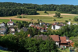
 View of Obermupf from the vineyard below the Trumleste |
|
| Location of the municipality | |
  |
|
Obermumpf ( Swiss German : ˈoːbəɾˌmumpf ) is a municipality in the Swiss canton of Aargau . It belongs to the Rheinfelden district and is located in the west of the Fricktal region , two kilometers south of the border with Germany .
geography
Obermumpf is located in the middle of the Fischingertal , a side valley of the High Rhine that runs from southeast to northwest . The flat valley floor is barely more than 100 meters wide and merges into a deep gorge below the village. The adjacent hills are very steep and wooded in the lower area, but in the upper area they merge into extensive plateaus where agriculture is practiced. These are the Mumpferflue ( 511 m above sea level ) in the north, the Eikerberg ( 509 m above sea level ) in the east, the Hellikerberg ( 541 m above sea level ) in the south and the Looberg ( 581 m above sea level) . M. ) in the west. The settlement area extends over a length of around one and a half kilometers along the stream, the greater part being on the right bank.
The area of the municipality is 502 hectares , of which 191 hectares are forested and 48 hectares are built over. The highest point is at 555 m above sea level. M. on the Looberg plateau, the deepest at 320 m above sea level. M. in the gorge of the Fischingerbach. Neighboring communities are Mumpf in the northwest, Stein in the north, Münchwilen in the northeast, Schupfart in the east, Hellikon in the south and Zuzgen in the west.
history
Various finds show that the area was inhabited as early as the Neolithic around 6,500 years ago. Several stone slab graves indicate that the Alemanni settled in the 7th / 8th centuries. Settled here in the 19th century. Obermumphier was first mentioned in a document in 1302 in a register of the diocese of Basel . The place name comes from the Latin ad montem ferri , which means "near the Eisenberg". The Mumpferfluh was an important observation point on the northern border of the Roman Empire during the second half of the 4th century . The church was built in the 10th or 11th century when the Säckingen monastery was founded .
The rulers in the Middle Ages were the Counts of Homberg-Tierstein , and from 1232 the Habsburgs . After the Waldshut War of 1468, they pledged the entire Fricktal to Burgundy . When the Burgundians were defeated by the Confederates during the Burgundian Wars , Obermumpf came back under Austrian rule in 1477. After the imperial reform of the Austrian Emperor Maximilian I , Obermumpf belonged to Upper Austria from 1491 and was located in the Fricktal region, a subordinate administrative unit of the Rheinfelden cameramen (from 1752 in the Breisgau district ). The lower jurisdiction initially lay with the Säckinger Dinghof Stein , from 1498 with the Säckinger Schultheissen; shortly after 1600 it was incorporated into the Bailiwick of Eiken .
In the 17th century there were hardly any longer times of peace. The Rappenkrieg , a peasant uprising that broke out in the neighboring village of Mumpf , lasted from 1612 to 1614. The Thirty Years' War , which also affected the Fricktal between 1633 and 1638, threw the village back in its economic development. Foreign troops also moved through the region during the War of the Palatinate Succession (1688–1697). In 1797 the Fricktal became a French protectorate after the Peace of Campo Formio . During the Second Coalition War , the front line between the armies of France and Austria ran here . On February 20, 1802, Obermumpf became a municipality in the Frick district of the Fricktal canton , which joined the Helvetic Republic in August . The municipality has belonged to the canton of Aargau since February 19, 1803.
For centuries, the villagers lived from agriculture and viticulture. There was also a flour mill and a forge. The vines completely disappeared at the beginning of the 19th century due to the phylloxera epidemic. There has only been a vineyard again since the 1970s . Due to the Kulturkampf , the parish split up at the end of the 19th century. The Christian Catholics took over the parish church in 1898, the emergency church of the Roman Catholics built four years earlier gave way to a new parish church in 1962. The population has always increased slightly. At the same time Obermumpf changed from a farming community to a residential community.
coat of arms
The blazon of the municipal coat of arms reads: "In yellow, blue sword with black pommel and blue key with black bow, placed crosswise." In 1936 an unofficial municipal coat of arms appeared on various club flags, in a yellow field a vine on a green three-mountain. Since four other communities already had a vine in their coat of arms, the cantonal coat of arms commission suggested using the coat of arms of the church patrons St. Peter and St. Paul, which has been affixed above the church door since 1738. The local council approved this proposal in 1965.
Attractions
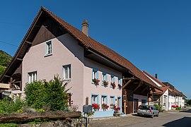
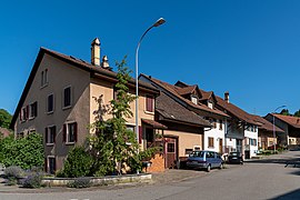
The village image is characterized by eaves-standing multi-purpose buildings from the late 18th and 19th centuries. The mostly alley-like closed development along the old street accentuates the impression of a street village . A little off the beaten track, on the northeast slope of the Looberg, is the church district. The Christian Catholic parish church of St. Peter and Paul , surrounded by the cemetery , was almost completely rebuilt in the Baroque style in 1738; the tower from the late 15th century has been preserved from the previous church. Next to the church is the Christian Catholic rectory , the oldest part of which dates from 1480.
View of the b / w part of Obermumpf

Christian Catholic Church of St. Peter and Paul

Christian Catholic Church and Rectory
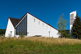
Roman Catholic Church
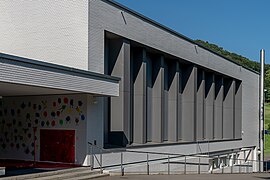
Gymnasium (schoolhouse)
Hofnet
Oberdorf


population
The population developed as follows:
| year | 1768 | 1850 | 1900 | 1930 | 1950 | 1960 | 1970 | 1980 | 1990 | 2000 | 2010 |
| Residents | 267 | 508 | 503 | 536 | 595 | 605 | 727 | 714 | 861 | 980 | 1020 |
On December 31, 2019, 1046 people lived in Obermumpf, the proportion of foreigners was 15.5%. In the 2015 census, 46.4% described themselves as Roman Catholic , 15.5% as Reformed and 11.5% as Christian Catholic ; 26.6% were non-denominational or of other faiths. In the 2000 census, 93.0% said their main language was German , 3.5% Albanian and 1.3% French .
Politics and law
The assembly of those entitled to vote, the municipal assembly , exercises legislative power. The executing authority is the five-member municipal council . He is elected by the people in the majority procedure, his term of office is four years. The parish council leads and represents the parish. To this end, it implements the resolutions of the municipal assembly and the tasks assigned to it by the canton. The Rheinfelden District Court is the first instance responsible for legal disputes . Obermumpf belongs to the Friedensrichterkreis XIV (Rheinfelden).
economy
According to the company structure statistics (STATENT) collected in 2015, there are around 150 jobs in Obermumpf, of which 21% are in agriculture, 29% in industry and 50% in the service sector. Most of the employed people are commuters and work in the larger communities of the Fricktal and in the agglomeration of the city of Basel .
Viticulture is also of importance . On the exposed southern slope of the Mumpferfluh, an area of 5.4 hectares was planted with vines in 2018. Ten different varieties are grown, with Pinot Noir and Riesling × Sylvaner and Gewürztraminer predominating.
traffic
Obermumpf is away from the main traffic axes, but is easily accessible via the canton road 491 running from Mumpf to Schupfart . The closest connection to the A3 motorway is at Eiken . The connection to the public transport network takes place via the post bus line from Möhlin train station through the Fischingertal to Wegenstetten . On weekends a night bus runs from Möhlin through the Möhlintal and Fischingertal back to Möhlin.
education
The community has a kindergarten and a primary school . After the upper school center Fischingertal in Mumpf was closed in July 2019, the secondary and secondary school students attend classes at the Unteres Fricktal District School (KUF) in the Engerfeld Rheinfelden school complex. The district school can be attended either in Rheinfelden or Möhlin. On the basis of an inter-cantonal agreement, young people from parts of the Fricktal can complete high school in Muttenz ( Canton Basel-Landschaft ) or in Basel .
literature
- Dominik Sauerländer: Obermumpf. In: Historical Lexicon of Switzerland .
- Edith Hunziker, Peter Hoegger: The art monuments of the canton of Aargau . Ed .: Society for Swiss Art History . Volume IX, Rheinfelden district. Bern 2011, ISBN 978-3-906131-94-8 , pp. 368-378 .
Web links
Individual evidence
- ↑ Cantonal population statistics 2019. Department of Finance and Resources, Statistics Aargau, March 30, 2020, accessed on April 2, 2019 .
- ↑ Cantonal population statistics 2019. Department of Finance and Resources, Statistics Aargau, March 30, 2020, accessed on April 2, 2019 .
- ↑ a b Beat Zehnder: The community names of the canton of Aargau . In: Historical Society of the Canton of Aargau (Ed.): Argovia . tape 100 . Verlag Sauerländer, Aarau 1991, ISBN 3-7941-3122-3 , p. 326-327 .
- ^ National map of Switzerland, sheets 1068 and 1069, Swisstopo.
- ↑ Standard area statistics - municipalities according to 4 main areas. Federal Statistical Office , November 26, 2018, accessed on May 11, 2019 .
- ↑ a b Hunziker, Hoegger: The art monuments of the canton of Aargau. P. 568.
- ↑ Hunziker, Hoegger: The monuments of the Canton of Aargau. P. 369.
- ^ Joseph Galliker, Marcel Giger: Municipal coat of arms of the Canton of Aargau . Lehrmittelverlag des Kantons Aargau, book 2004, ISBN 3-906738-07-8 , p. 238 .
- ↑ Hunziker, Hoegger: The monuments of the Canton of Aargau. P. 370.
- ↑ Population development in the municipalities of the Canton of Aargau since 1850. (Excel) In: Eidg. Volkszählung 2000. Statistics Aargau, 2001, archived from the original on October 8, 2018 ; accessed on May 11, 2019 .
- ↑ Resident population by religious affiliation, 2015. (Excel) In: Population and Households, Community Tables 2015. Statistics Aargau, accessed on May 11, 2019 .
- ↑ Swiss Federal Census 2000: Economic resident population by main language as well as by districts and municipalities. (Excel) Statistics Aargau, archived from the original on August 10, 2018 ; accessed on May 11, 2019 .
- ↑ circles of justice of the peace. Canton of Aargau, accessed on June 19, 2019 .
- ↑ Statistics of the corporate structure (STATENT). (Excel, 157 kB) Statistics Aargau, 2016, accessed on May 11, 2019 .
- ↑ Grape harvest control 2018 Canton Aargau. (PDF, 2.4 MB) Agricultural Center Liebegg, 2019, accessed on June 19, 2019 .