
Wallbach AG
| AG is the abbreviation for the canton of Aargau in Switzerland and is used to avoid confusion with other entries of the name Wallbach . |
| Wallbach | |
|---|---|
 |
|
| State : |
|
| Canton : |
|
| District : | Rheinfelden |
| BFS no. : | 4261 |
| Postal code : | 4323 |
| Coordinates : | 635 047 / 267 596 |
| Height : | 288 m above sea level M. |
| Height range : | 281–351 m above sea level M. |
| Area : | 4.55 km² |
| Residents: | 1983 (December 31, 2019) |
| Population density : | 436 inhabitants per km² |
|
Proportion of foreigners : (residents without citizenship ) |
15.4% (December 31, 2019) |
| Website: | www.wallbach.ch |
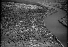
 View of Wallbach |
|
| Location of the municipality | |
  |
|
Wallbach ( Swiss German : ˈʋɑlˌbɑχ ) is a municipality in the Swiss canton of Aargau . It belongs to the Rheinfelden district and is located in the west of the Fricktal region on the Upper Rhine and on the border with Germany .
geography
The village stretches for almost two kilometers along the Rhine , which here flows northwards instead of the usual westwards. The reason for this is a terminal moraine up to four kilometers wide west of the village, which protrudes far into the plain from the foothills of the Table Jura . It was formed during the Riss Ice Age around 140,000 years ago and formed the north-western end point of the alpine glaciation. As a result of the erosion , an elevated, extensive plain was created that slopes steeply to the river on the eastern and northern edges; the difference in altitude is more than 60 meters in places. The settlement area on the Rhine has grown together with that of Mumpf . On the opposite side of the river is the village of Wallbach (Baden-Württemberg) , which belongs to Bad Säckingen . The municipality of Wallbach is part of the Fischingertal , but unlike the other three valley municipalities , it is not geographically located directly in the valley.
The area of the municipality is 455 hectares , of which 132 hectares are forested and 89 hectares are built over. The highest point is at 351 m above sea level. M. on the plateau of the moraine, the deepest at 280 m above sea level. M. on the Rhine. Neighboring communities in Switzerland are Möhlin in the northwest, Zeiningen in the southwest and Mumpf in the southeast. In the east Wallbach borders on the German communities Bad Säckingen and Wehr .
history
There were once three Roman watchtowers in the municipality of Wallbach , which from 370 onwards secured the northern border of the empire. The watchtower in the "Stelli" was the largest of its kind on the Upper Rhine that has been preserved. In 1911 the remains of a manor from the 1st or 2nd century came to light during excavations . At the beginning of the 5th century, the Romans finally withdrew.
The first written mention of Walabuok took place in 1281. The place name comes from the Old High German Walahbuohha and means "beech trees of the Walah". Walah refers to a Welsh or Roman-Celtic pre-settler. After the Counts of Homberg-Tierstein died out , sovereignty passed to the Habsburgs in 1232 . After the Waldshut War of 1468, they pledged the entire Fricktal to Burgundy . When the Burgundians were defeated by the Confederates during the Burgundian Wars , Wallbach came back under Austrian rule in 1477.
As a result of the imperial reform of the Austrian Emperor Maximilian I , Wallbach belonged to Upper Austria from 1491 and lay in the Möhlinbach region , a subordinate administrative unit of the Rheinfelden cameramen (from 1752 in the Upper Office of Breisgau ). In the 17th century there were hardly any longer times of peace. The Rappenkrieg , a peasant uprising that broke out in the neighboring village of Mumpf, lasted from 1612 to 1614. The Thirty Years' War , which also affected the Fricktal between 1633 and 1638, threw the village back in its economic development. Foreign troops also moved through the region during the War of the Palatinate Succession (1688–1697).
In 1797 the Fricktal became a French protectorate after the Peace of Campo Formio . During the Second Coalition War , the front line between the armies of France and Austria ran here . On February 20, 1802 Wallbach became a municipality in the Rheinfelden district of the Fricktal canton , which joined the Helvetic Republic in August . The municipality has belonged to the canton of Aargau since February 19, 1803.
For centuries, the villagers lived from fishing and rafting on the Rhine. The "Rheingenossenschaft", which has been in use since around 1500, controlled shipping traffic between Basel and Laufenburg . The opening of the Bözberg Railway in 1875 changed little for the time being, as the village did not have its own train station. After the construction of the Ryburg-Schwörstadt hydropower plant and the damming of the Rhine, the last fishermen and raftsmen had to give up their activities. As a result, the importance of industry increased continuously. The population has more than doubled since 1950.
coat of arms
The blazon of the municipal coat of arms reads: "A white double cross pawed in red, raised by a six-pointed white star." The coat of arms was introduced shortly after the canton was founded in 1803. Another star was added around 1930. A similar double cross is on the tower of the Wallbach parish church, which indicates the close ties to the collegiate church in Bad Säckingen .
Attractions
,_katholische_Kirche.jpg)
,_christkatholische_Kapelle.jpg)
Several houses from the 19th century have been preserved in the old village center. These are concentrated on two quarters that are directly adjacent to the river bank. The only house that still has a thatched roof is on Unterdorfstrasse and dates from the 17th century. The St. Sebastian Chapel was built in 1698 . It was initially part of the Roman Catholic parish of Mumpf, and has been used by the Christian Catholic parish of Obermumpf-Wallbach since 1898 . In 1892 the Roman Catholics built their own house of worship, the parish church of St. Maria.
population
The population developed as follows:
| year | 1768 | 1850 | 1900 | 1930 | 1950 | 1960 | 1970 | 1980 | 1990 | 2000 | 2010 | 2017 | 2018 | 2019 |
| Residents | 290 | 638 | 661 | 639 | 734 | 896 | 1022 | 1068 | 1229 | 1526 | 1818 | 1958 | 1950 | 1983 |
On December 31, 2019, 1983 people lived in Wallbach, the proportion of foreigners was 15.4%. As of December 31, 2019, 40.9% were non-denominational or of other faith. 38.2% described themselves as Roman Catholic , 17.5% as Reformed and 3.3% as Christian Catholic ; . 94.2% said German as their main language in the 2000 census , 1.2% each French and Italian .
Politics and law
The assembly of those entitled to vote, the municipal assembly , exercises legislative power. The executing authority is the five-member municipal council . He is elected by the people in the majority procedure, his term of office is four years. The parish council leads and represents the parish. To this end, it implements the resolutions of the municipal assembly and the tasks assigned to it by the canton. The Rheinfelden District Court is the first instance responsible for legal disputes . Wallbach belongs to the Friedensrichterkreis XIV (Rheinfelden).
economy
According to the corporate structure statistics (STATENT) collected in 2015, Wallbach has around 880 jobs, 4% of them in agriculture, 67% in industry and 29% in the service sector. The most important companies are Novoplast AG, which produces all kinds of plastic parts for the industrial and household sectors, Forbo Siegling Switzerland, one of the leading manufacturers of drive belts, conveyor and processing belts, and the watch manufacturer Roamer . There are also smaller commercial and service companies. Numerous workers are commuters and work in the larger communities of the Fricktal and in the agglomeration of the city of Basel.
traffic
Hauptstrasse 3 runs about half a kilometer south between Basel and Zurich ; the village center is not affected by through traffic. The closest connections to the A3 motorway are at Rheinfelden and Eiken . The connection to the public transport network is made by a Postbus line that runs from Möhlin train station through Fischingertal to Wegenstetten . On weekends, a night bus runs from Möhlin through the Möhlintal and Fischingertal back to Möhlin.
education
The community has a kindergarten and a primary school . After the upper school center Fischingertal in Mumpf was closed in July 2019, the junior high and secondary school students attend classes at the Unteres Fricktal district school (KUF) in the Engerfeld Rheinfelden school complex; the district students are taught at the district school in Möhlin . On the basis of an inter-cantonal agreement, young people from parts of the Fricktal can complete high school in Muttenz ( Canton Basel-Landschaft ) or in Basel .
Personalities
- Jan Lurvink (* 1965), writer
literature
- Dominik Sauerländer: Wallbach. In: Historical Lexicon of Switzerland .
- Edith Hunziker, Peter Hoegger: The art monuments of the canton of Aargau . Ed .: Society for Swiss Art History . Volume IX, Rheinfelden district. Bern 2011, ISBN 978-3-906131-94-8 , pp. 423-428 .
Web links
Individual evidence
- ↑ Cantonal population statistics 2019. Department of Finance and Resources, Statistics Aargau, March 30, 2020, accessed on April 2, 2019 .
- ↑ Cantonal population statistics 2019. Department of Finance and Resources, Statistics Aargau, March 30, 2020, accessed on April 2, 2019 .
- ↑ a b Beat Zehnder: The community names of the canton of Aargau . In: Historical Society of the Canton of Aargau (Ed.): Argovia . tape 100 . Verlag Sauerländer, Aarau 1991, ISBN 3-7941-3122-3 , p. 454-456 .
- ^ National map of Switzerland, sheet 1048, Swisstopo.
- ↑ Standard area statistics - municipalities according to 4 main areas. Federal Statistical Office , November 26, 2018, accessed on May 11, 2019 .
- ^ Martin Hartmann, Hans Weber: The Romans in Aargau . Verlag Sauerländer, Aarau 1985, ISBN 3-7941-2539-8 , p. 205-206 .
- ^ Joseph Galliker, Marcel Giger: Municipal coat of arms of the Canton of Aargau . Lehrmittelverlag des Kantons Aargau, book 2004, ISBN 3-906738-07-8 , p. 309 .
- ↑ Edith Hunziker, Peter Hoegger: The art monuments of the canton of Aargau . Ed .: Society for Swiss Art History . Volume IX, Rheinfelden District, 2011, ISBN 978-3-906131-94-8 , pp. 424-425 .
- ↑ Population development in the municipalities of the Canton of Aargau since 1850. (Excel) In: Eidg. Volkszählung 2000. Statistics Aargau, 2001, archived from the original on October 8, 2018 ; accessed on May 11, 2019 .
- ↑ Statistical Yearbook of the Canton of Aargau 2019 (PDF) Statistics Aargau, accessed on June 11, 2020 .
- ↑ Municipality in figures - population figures as at 31.12. Wallbach municipality, accessed on June 11, 2020 .
- ↑ Municipality in figures - population figures as at 31.12. Wallbach municipality, accessed on June 11, 2020 .
- ↑ Swiss Federal Census 2000: Economic resident population by main language as well as by districts and municipalities. (Excel) Statistics Aargau, archived from the original on August 10, 2018 ; accessed on May 11, 2019 .
- ↑ circles of justice of the peace. Canton of Aargau, accessed on June 19, 2019 .
- ↑ Statistics of the corporate structure (STATENT). (Excel, 157 kB) Statistics Aargau, 2016, accessed on May 11, 2019 .