
Maids
| Maids | |
|---|---|
 |
|
| State : |
|
| Canton : |
|
| District : | Rheinfelden |
| BFS no. : | 4253 |
| Postal code : | 4312 |
| Coordinates : | 628 333 / 264058 |
| Height : | 326 m above sea level M. |
| Height range : | 306–608 m above sea level M. |
| Area : | 11.02 km² |
| Residents: | 3889 (December 31, 2019) |
| Population density : | 353 inhabitants per km² |
|
Proportion of foreigners : (residents without citizenship ) |
15.4% (December 31, 2019) |
| Website: | www.magden.ch |
 Maids |
|
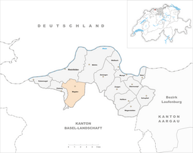
| Location of the municipality | |
  |
|
Magden ( Swiss German : Magde ˈmɑgdə ) is a municipality in the Swiss canton of Aargau . It belongs to the Rheinfelden district , lies in the west of the Fricktal region , about three kilometers south of the border with Germany , and borders the canton of Basel-Landschaft .
geography
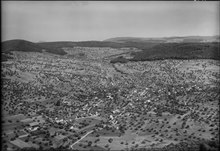
The village is located on the Magdenerbach , which flows first to the west, then to the north and flows into the Rhine near the old town of Rheinfelden . The flat valley floor is an average of 200 meters wide and is bordered by the hills of the Table Jura . These rise steeply in the lower area and merge into plateaus that are partly wooded and partly used for agriculture. On the north side of the Magdenertal lies the «Galgen» ( 450 m above sea level ), an extension of the 632 meter high Sonnenberg. The Schönenberg ( 469 m above sea level ) rises on the west side of the valley . In the center of the village, the valley of the Wintersingerbach branches off towards the south-southeast, in which the hamlet Iglingerhof ( 370 m above sea level ) is located. Between this valley and the Magdenertal is the Önsberg ( 563 m above sea level ). The Wintersinger Valley branches out about one kilometer south of the village center; In the south-south-west direction there is a side valley almost three kilometers long, simply called the "valley". In between, the 514 meter high Chüller rises. In the far southwest is the 607 meter high Halmet.
The area of the municipality is 1102 hectares , of which 464 hectares are forested and 128 hectares are built over. The highest point is on the summit of Halmet, the lowest at 308 m above sea level. M. am Magdenerbach. Neighboring communities in Aargau are Olsberg in the west (with a small exclave in the south), Rheinfelden in the northwest and Möhlin in the northeast. Neighboring communities in the canton of Baselland are Arisdorf and Hersberg in the southwest, Nusshof in the south, Wintersingen in the southeast and Maisprach in the east.
history
Various individual finds in the municipality indicate a settlement during Roman times . An inscription from the reign of Emperor Valentinian I found in Kaiseraugst describes the restoration of the "murum magidunensem", the east wall of the fort five kilometers to the west. It was first mentioned in a document in 804, when the Alemannic nobleman Morand donated the Magden court ( in curte magaduninse ) to the St. Gallen Abbey . The place name comes from the Celtic Magodunon and means "fortified structure in the open field". In 1036 Count Ulrich von Lenzburg bequeathed his entire property in Magden to the Beromünster Abbey . The church mentioned at that time may have been built in the 7th century. After the Lenzburg population died out in 1173, Emperor Barbarossa issued a letter of protection to Beromünster Abbey and confirmed its ownership in Magden.
The sovereignty passed from the Counts of Homberg-Tierstein to the Habsburgs in 1232 . In 1255 the village of Iglingen, today's Iglingerhof, was first mentioned in a document. In 1351 the Beromünster Abbey had to sell its entire property in Magden to the Olsberg Monastery due to a financial emergency . On November 18, 1409, the "Battle of Magden" took place: citizens of the city of Rheinfelden returned from a cattle raid from the Waldenburgertal . The Basel bidder lay in wait for them at Magden's. 80 Rheinfelder and 30 Basel bidder died in this dispute. The village of Deschlikon in the "valley", which was built at the end of the 12th century, was completely destroyed by a landslide in 1437 and was not rebuilt afterwards. In 1461 the neighboring villages of Magdens came into the possession of the city of Basel . After the Waldshut War of 1468, the Habsburgs pledged the entire Fricktal to Burgundy . When the Burgundians were defeated by the Confederates during the Burgundian Wars , Magden came under Austrian rule again in 1477.
After the imperial reform of the Austrian Emperor Maximilian I in 1491, Magden belonged to Upper Austria and was located in the Möhlinbach region, a subordinate administrative unit of the Rheinfelden cameramen (from 1752 in the Oberamt Breisgau ). On May 30, 1499, the 6,000-strong Habsburg Imperial Army moved into quarters in Magden during the Swabian War. The soldiers plundered the region and all residents of Magden, Maisprach and Wintersingen had to flee to Liestal . In 1525, during the turmoil of the Reformation , the sister house in Iglingen was abandoned and the residents of Magdens participated in the looting of the Olsberg monastery. In the 17th century there were hardly any longer times of peace. The Rappenkrieg , a peasant uprising, lasted from 1612 to 1614. The Thirty Years' War , which also affected the Fricktal between 1633 and 1638, threw the village back in its development. The Swedes in particular left great devastation and plundered the village. The small village of Höflingen on the border with Rheinfelden was completely destroyed and not rebuilt afterwards. Foreign troops also moved through the region during the War of the Palatinate Succession (1688–1697).
In 1797 the Fricktal became a French protectorate after the Peace of Campo Formio . During the Second Coalition War , the front line between the armies of France and Austria ran here . The population suffered from recruiting, billeting, requisitions, war taxes and compulsory labor. On February 20, 1802 Magden became a municipality in the Rheinfelden district of the Fricktal canton , which joined the Helvetic Republic in August . The municipality has belonged to the canton of Aargau since February 19, 1803. From 1813 to 1815, more than 16,000 Austrian soldiers had to be quartered, and one eighth of the village population died of typhus . After a severe storm in June 1814 and two bad harvests, the first major wave of emigration to the United States followed . There were further waves of emigration in the 1840s and 1850s.
During the Kulturkampf , the villagers converted to the Christian Catholic denomination , until 1960 Magden was the only Swiss community with a Christian Catholic majority. At the end of the 19th century, the phylloxera epidemic plunged viticulture into a deep crisis. In its place came fruit growing (especially cherries ). In 1914 it was connected to the electricity network. During the Second World War, the number of soldiers in the village was at times higher than that of the inhabitants. The population rose only slightly until 1960, but then Magden experienced an unprecedented boom. More and more people moved here from the city of Basel and its suburbs; as a result, the majority of the village was reformed. In just under fifty years, the population tripled.
coat of arms
The blazon of the municipal coat of arms reads: "In white on green ground a green apple tree with nine red fruits, next to two vines with two blue grapes and two green leaves on a red stick." The coat of arms, first shown on the municipal seal in 1872, represents the two main pillars of Magden agriculture, fruit growing and viticulture.
Attractions

- Christian Catholic Parish Church of St. Martin: First mentioned in 1036; Rebuilt in 1620 in Gothic style; Baroque style around 1750 .
- 20-part carillon (Ref.Kirchgemeindehaus Gässli)
- Madonna fresco at Maiengässli House 3
- St. Niklaus Chapel at the Iglingerhof
- Museum switchboard
- Magdalena spring
- Basement of loyalty
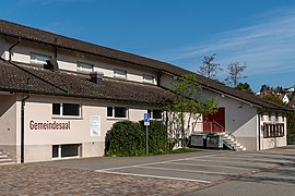
Community hall

school
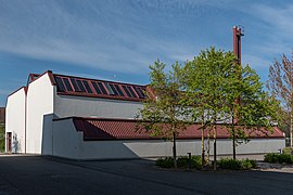
Sports hall Juch
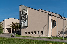
Reformed parish hall with carillon
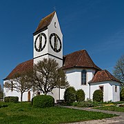
Christian Catholic Church of St. Martin


population
The population developed as follows:
| year | 1768 | 1850 | 1900 | 1930 | 1950 | 1960 | 1970 | 1980 | 1990 | 2000 | 2010 |
| Residents | 869 | 1075 | 894 | 975 | 975 | 1107 | 1799 | 2218 | 2665 | 3043 | 3628 |
On December 31, 2019, 3889 people lived in Magden, the proportion of foreigners was 15.4%. In the 2015 census, 31.0% described themselves as Reformed , 24.2% as Roman Catholic and 8.8% as Christian Catholic ; 36.0% were non-denominational or belonged to other faiths. In the 2000 census, 92.9% said their main language was German , 1.5% French , 1.4% English , 1.0% Albanian and 0.9% Italian .
Politics and law

The assembly of those entitled to vote, the municipal assembly , exercises legislative power. The executing authority is the five-member municipal council . He is elected by the people in the majority procedure, his term of office is four years. The parish council leads and represents the parish. To this end, it implements the resolutions of the municipal assembly and the tasks assigned to it by the canton. The Rheinfelden District Court is the first instance responsible for legal disputes . Magden belongs to the Friedensrichterkreis XIV (Rheinfelden).
economy
According to the company structure statistics (STATENT) collected in 2015, there are around 770 jobs in Magden, 7% of them in agriculture, 29% in industry and 64% in the service sector. Industrial companies are active in measurement and control technology, process technology, chemical plant engineering and metal processing. Most of the employed people are commuters and work in the larger communities of the Fricktal and in the agglomeration of the city of Basel .
Viticulture continues to be of great importance . In 2018, an area of 8.9 hectares was planted with vines on the exposed south-west and south-facing slopes of the «Galgen». Eleven different varieties are grown, with Pinot Noir and Kerner predominating.
traffic
Magden is located on Kantonsstrasse 497 between Rheinfelden and Gelterkinden , a little more than two kilometers south of the Rheinfelden junction of the A3 motorway . Other roads lead to Sissach and Olsberg - Kaiseraugst . The connection to the public transport network is made by a post bus line that runs from Rheinfelden train station via Magden to Gelterkinden. Another post bus line connects Magden with Olsberg and Giebenach . On weekends there is a night bus from Rheinfelden via Magden to Gelterkinden.
education
The community has four kindergartens and two school houses in which the primary school , the junior high school and the secondary school are taught. The district school can be attended in Rheinfelden . On the basis of an inter-cantonal agreement, young people from parts of the Fricktal can complete high school in Muttenz ( Canton Basel-Landschaft ) or in Basel .
Personalities
- Walo Burkart (1887–1952), forester and archaeologist
- Karl Glatt (1912–2003), artist
- Emanuel Gut (1983), musician
- Theophil Roniger (1844–1913), founder of the Feldschlösschen brewery
- Kurt Stalder (1912–1996), Christian Catholic theologian
- Fridolin Stäuble (1817–1881), politician
literature
- Dominik Sauerländer: Magden. In: Historical Lexicon of Switzerland .
- Edith Hunziker, Peter Hoegger: The art monuments of the canton of Aargau . Ed .: Society for Swiss Art History . Volume IX, Rheinfelden district. Bern 2011, ISBN 978-3-906131-94-8 , pp. 313-333 .
Web links
Individual evidence
- ↑ Cantonal population statistics 2019. Department of Finance and Resources, Statistics Aargau, March 30, 2020, accessed on April 2, 2019 .
- ↑ Cantonal population statistics 2019. Department of Finance and Resources, Statistics Aargau, March 30, 2020, accessed on April 2, 2019 .
- ↑ a b Beat Zehnder: The community names of the canton of Aargau . In: Historical Society of the Canton of Aargau (Ed.): Argovia . tape 100 . Verlag Sauerländer, Aarau 1991, ISBN 3-7941-3122-3 , p. 259-261 .
- ^ National map of Switzerland, sheet 1068, Swisstopo.
- ↑ Standard area statistics - municipalities according to 4 main areas. Federal Statistical Office , November 26, 2018, accessed on May 11, 2019 .
- ^ Martin Hartmann, Hans Weber: The Romans in Aargau . Verlag Sauerländer, Aarau 1985, ISBN 3-7941-2539-8 , p. 182 .
- ↑ Bruno Müller: Magden in the Second World War. (PDF, 302 kB) Magden municipality, accessed on March 20, 2018 .
- ^ Joseph Galliker, Marcel Giger: Municipal coat of arms of the Canton of Aargau . Lehrmittelverlag des Kantons Aargau, book 2004, ISBN 3-906738-07-8 , p. 206 .
- ↑ Population development in the municipalities of the Canton of Aargau since 1850. (Excel) In: Eidg. Volkszählung 2000. Statistics Aargau, 2001, archived from the original on October 8, 2018 ; accessed on May 11, 2019 .
- ↑ Resident population by religious affiliation, 2015. (Excel) In: Population and Households, Community Tables 2015. Statistics Aargau, accessed on May 11, 2019 .
- ↑ Swiss Federal Census 2000: Economic resident population by main language as well as by districts and municipalities. (Excel) Statistics Aargau, archived from the original on August 10, 2018 ; accessed on May 11, 2019 .
- ↑ circles of justice of the peace. Canton of Aargau, accessed on June 19, 2019 .
- ↑ Statistics of the corporate structure (STATENT). (Excel, 157 kB) Statistics Aargau, 2016, accessed on May 11, 2019 .
- ↑ Grape harvest control 2018 Canton Aargau. (PDF, 2.4 MB) Agricultural Center Liebegg, 2019, accessed on June 19, 2019 .