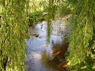
Magdenerbach
|
Magdenerbach Wintersingerbach |
||
|
The Magdenerbach above Rheinfelden |
||
| Data | ||
| Water code | CH : 456 | |
| location | Rheinfelden District , Canton Aargau , Switzerland | |
| River system | Rhine | |
| Drain over | Rhine → North Sea | |
| origin | The confluence of Wintersingerbach and Maispracherbach in Magden 47 ° 31 ′ 45 ″ N , 7 ° 48 ′ 36 ″ E |
|
| Source height | 321 m above sea level M. | |
| muzzle | in Rheinfelden in the Rhine Coordinates: 47 ° 33 '23 " N , 7 ° 47' 43" E ; CH1903: 626 849 / 267 367 47 ° 33 '23 " N , 7 ° 47' 43" O |
|
| Mouth height | 265 m above sea level M. | |
| Height difference | 56 m | |
| Bottom slope | 14 ‰ | |
| length | 3.9 km | |
| Catchment area | 40.8 km² | |
| Discharge at the Rheinfelden A Eo gauge : 33.2 km² |
MQ 1982-2014 Mq 1982-2014 |
380 l / s 11.4 l / (s km²) |
| Small towns | Rheinfelden | |
The Magdenerbach (sometimes also called Stadtbach in Rheinfelden ) is an almost four-kilometer-long left or southern tributary of the Rhine in the Rheinfelden district , in the north-western part of the canton of Aargau in Switzerland .
course
The Magdenerbach runs through the western part of the Fricktal region . It arises in the municipality of Magden at around 320 m above sea level. M. through the confluence of two source streams flowing from the canton of Basel-Landschaft : the Maispracherbach coming from the west (called Buuserbach in the upper reaches) and the Wintersingerbach flowing from the south .
From Magden the Magdenerbach flows in a predominantly north-northwest direction through a rather narrow valley between the "Berg" (419 m above sea level) in the west and the Steppberg (373 m above sea level) in the east towards Rheinfelden . At the southern edge of this city it is spanned by a motorway bridge of the A3 . In the center of Rheinfeld, the Magdenerbach crosses the Basel-Zurich railway line ( Bözberg line ) and then Hauptstrasse 3 . It then flows around the old town to the east, then coming from the south to around 266 m above sea level. M. in the east approach flowing Hochrhein to lead .
history
In Rheinfelden, the water ditch and commercial canals running in a semicircle around the old town used to be irrigated with the water of the stream . After completing these tasks, the Magdenerbach was diverted to the eastern side of the old town. The commercial canal from the Magdenerbach to the factory site in Oberfeld south of Rheinfelden existed for a long time. A small gorge west of the old town, the Heimendeckenloch, reminds of the old course of the stream.
Tributaries
- Magdenerbach
- Maispracherbach ( Buuserbach ) ( right source stream )
- Wintersingerbach ( right source stream )
- Cherbächli ( left source stream )
- Chummengrabenbach ( right source stream )
- Talbächli (right)
- Summerstallbächli (right)
- Binzholdenbächli (left)
- Stockacherbächli (left)
- Weidbächli (left)
- Badbächli (left)
- Griesbächli (right)
- Hölibächli (left)
- Usgland (right)
- Oedlestebächli (right)
- Hermlestebächli 1 (right)
- Wintersingerbach ( left source stream )
- Brunnbächli ( right source stream )
- Sättlerbächli (right)
- Guetlistenbächli (right)
- Fer ( left source stream )
- Chienisholzbächli (left)
- Mäsletenbächli (left)
- Griesbächli (left)
- Talbächli (left)
- Eglismattbächli (left)
- Steinlerbächli (left)
- Weidbächli (left)
- Grabenbächli (left)
- Hinter-Oensbergbach (right)
- Talbächli (left)
- Böwald (left)
- Leisibüel (right)
- Widebode (right)
- Göltschete (left)
- Talhof (left)
- Rinderweg (right)
- Huetgrundbächli (left)
- Brunnbächli ( right source stream )
- Birgleste (left)
- Chräbsebächli (left)
- Baumgarte 2 (right)
- Baumgarte 1 (right)
- Aengibächli (right)
- Fire (right)
- Rötibächli / Tellengrabenbach (right)
- Chrachen (left)
- Stierebründli (left)
- Rötigraben (left)
- Rötifeld (left)
- Buechgraben (left)
- Rötihau (left)
- S-arch trench (left)
- Mareilislochbach (left)
- Maispracherbach ( Buuserbach ) ( right source stream )
Individual evidence
- ↑ a b c d Geoserver of the Swiss Federal Administration ( information )
- ↑ Rheinfelden measuring station. In: Canton Aargau Department of Construction, Transport and Environment. Retrieved October 19, 2015 .
- ^ Designation in the canton of Basel-Landschaft
