
Hellikon
| Hellikon | |
|---|---|
 |
|
| State : |
|
| Canton : |
|
| District : | Rheinfelden |
| BFS no. : | 4251 |
| Postal code : | 4316 |
| Coordinates : | 636 572 / 262 239 |
| Height : | 414 m above sea level M. |
| Height range : | 396–637 m above sea level M. |
| Area : | 7.04 km² |
| Residents: | 785 (December 31, 2019) |
| Population density : | 112 inhabitants per km² |
|
Proportion of foreigners : (residents without citizenship ) |
5.0% (December 31, 2019) |
| Website: | www.hellikon.ch |
 View of Hellikon |
|
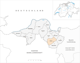
| Location of the municipality | |
  |
|
Hellikon ( Swiss German : ˈhelːikχə ) is a municipality in the Swiss canton of Aargau . It belongs to the Rheinfelden district , lies in the west of the Fricktal region around four kilometers southwest of the border with Germany and borders the canton of Basel-Landschaft .
geography
The village is located in the upper Möhlintal , through which the Möhlinbach flows from southeast to northwest . It consists of two parts: the lower village extends over a length of one kilometer along the Möhlinbach, the upper village lies west of it on the Talbach. The flat valley floor along the Möhlinbach is on average almost 200 meters wide and widens to almost 400 meters at the mouth of the Talbach. Both valleys are bordered by several hills of the Table Jura . In the lower area, these are very steep in places and in the upper area they merge into extensive plateaus on which agriculture is carried out.
To the east of the village rises the over a kilometer wide plateau of the Wabrig, which extends over a length of more than four kilometers. At Zuzgen the level is called Lohnberg, at Wegenstetten Hersberg. More than a kilometer long, deeply cut side valley of the Talbach extends to the west. It separates the Neulig plateau in the north from the Egg plateau in the south.
The area of the municipality is 704 hectares , of which 230 hectares are forested and 50 hectares are built over. The highest point is at 633 m above sea level. M. on the western edge of the Neulig plateau, the deepest at 397 m above sea level. M. am Möhlinbach. The municipality of Hellikon is part of the Aargau Jura Park, a “Regional Nature Park of National Importance”. Neighboring communities in Aargau are Zuzgen in the northwest, Obermumpf in the northeast, Schupfart in the east and Wegenstetten in the southeast. Neighboring communities in the canton of Basel-Landschaft are Buus in the west and Hemmiken in the southwest.
history
Hellincon was first mentioned in a document in 1209. The place name comes from the Old High German Hellinghofun and means "at the farms of the Hello clan". The name suggests a settlement by the Alemanni in the 6th or 7th century. In the Middle Ages, the Counts of Homberg and Farnsburg as well as the Johanniterkommende Rheinfelden and the Cistercian Sisters in Olsberg were the most important landowners. The lower jurisdiction was owned by the Zeiningen court , which in turn belonged to the Säckingen women's monastery . The Habsburgs had been rulers and holders of blood jurisdiction since the late 12th century .
After the Waldshut War of 1468, the Habsburgs pledged the entire Fricktal to Burgundy . When the Burgundians were defeated by the Confederates during the Burgundian Wars , Hellikon came under Austrian rule again in 1477. As a result of the imperial reform of the Austrian Emperor Maximilian I , Hellikon belonged to Upper Austria from 1491 and was located in the Möhlinbach region , a subordinate administrative unit of the Rheinfelden cameramen (from 1752 in the Upper Office Breisgau ). In the 17th century there were hardly any longer times of peace. The Rappenkrieg , a peasant uprising, lasted from 1612 to 1614. The Thirty Years War , which also affected the Fricktal between 1633 and 1638, threw the village back in its economic development. Foreign troops also moved through the region during the War of the Palatinate Succession (1688–1697).
In 1797 the Fricktal became a French protectorate after the Peace of Campo Formio . During the Second Coalition War , the front line between the armies of France and Austria ran here . On February 20, 1802, Hellikon became a municipality in the Rheinfelden district of the Fricktal canton , which joined the Helvetic Republic in August . Since February 19, 1803, the community has belonged to the Rheinfelden district in the canton of Aargau. From 1865 a stagecoach ran to Möhlin , which was replaced by a postbus line in 1922 . From 1895 to 1969 a trimmings factory provided additional income opportunities alongside the dominant agriculture.

Hellikon was never an independent church. The right bank part has always belonged to Wegenstetten , the left bank part to Zuzgen . The latter was assigned to the parish of Wegenstetten in 1788 as part of the Josephine reforms . A significant part of the population converted to the Christian Catholic denomination during the Kulturkampf in 1873 (organized in the parish of Wegenstetten since 1898). In 1947/48 the Christ Catholics built their own church, which ended the shared use of the Wendelins Chapel with the Roman Catholics.
At the Christmas party in 1875, a tragic accident occurred when the stairwell of the Hellikon school building , which had been built ten years earlier, collapsed. 76 people were killed, most of them children. Between 1850 and 1950 the population decreased by over twenty percent. Grain and viticulture formed the basis of livelihoods until the 20th century , with viticulture having to be given up due to phylloxera and powdery mildew epidemics. Hellikon changed from a farming community to a residential community as more and more people from the Basel region moved here. Since the early 1980s, the population has increased by more than a third.
coat of arms
The blazon of the municipal coat of arms reads: "In blue over a green three-mountain three yellow Norway morels." The coat of arms was introduced in 1924. Although the coat of arms was known earlier, it was never documented. In 1966 the coat of arms got its current form with yellow instead of brown morels.
Attractions
In Hellikon there are two chapels from the 17th century, the Sebastian chapel in Oberdorf and the Wendelins chapel in Ausserdorf up the valley. In the center of the village in particular, which is listed in the inventory of places worthy of protection in Switzerland , there are several buildings from the late 17th to 19th centuries. These are earlier multi-purpose agricultural buildings in the typical form of this region with living and utility areas under a common ridge. An almost closed row of houses along the east side of the main street, around 250 meters long, is particularly well preserved.
school

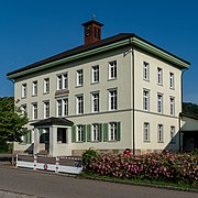
School complex

School complex
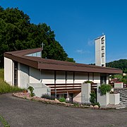
New Sebastian Chapel

Parish hall


population
The population developed as follows:
| year | 1768 | 1850 | 1900 | 1930 | 1950 | 1960 | 1970 | 1980 | 1990 | 2000 | 2010 |
| Residents | 252 | 681 | 581 | 579 | 539 | 558 | 592 | 582 | 708 | 747 | 782 |
On December 31, 2019, 785 people lived in Hellikon, the proportion of foreigners was 5%. In the 2015 census, 48.8% described themselves as Roman Catholic , 15.2% as Reformed and 15.2% as Christian Catholic ; 20.8% were non-denominational or of other faiths. Hellikon is thus the municipality with the highest percentage of Christian Catholics in Switzerland. In the 2000 census, 95.6% said German as their main language and 2.4% Albanian .
Politics and law
The assembly of those entitled to vote, the municipal assembly , exercises legislative power. The executing authority is the five-member municipal council . He is elected by the people in the majority procedure, his term of office is four years. The parish council leads and represents the parish. To this end, it implements the resolutions of the municipal assembly and the tasks assigned to it by the canton. The Rheinfelden District Court is the first instance responsible for legal disputes . Hellikon belongs to the Friedensrichterkreis XIV (Rheinfelden).
economy
According to the corporate structure statistics (STATENT) collected in 2015, Hellikon has around 160 jobs, of which 44% are in agriculture, 20% in industry and 36% in the service sector. Smaller commercial enterprises are active in the plastics processing and construction industry. Most of the employed people are commuters and work in the larger communities of the Fricktal and in the agglomeration of the city of Basel .
traffic
Hellikon is on Kantonsstrasse 494, which runs from Möhlin through the Möhlintal to Wegenstetten . A smaller side street leads to Buus . The closest connections to the A3 motorway are at Rheinfelden and Eiken . The connection to the public transport network is made by the Postbus line from Möhlin train station to Wegenstetten. On weekends a night bus runs from Möhlin through the Möhlintal and Fischingertal back to Möhlin.
education
The community has a kindergarten and a primary school (see also Hellikon school ). The secondary school and the district school are run together with the entire Möhlintal in Möhlin . The secondary school is divided into classes and is attended in Wegenstetten and Zeiningen . On the basis of an inter-cantonal agreement, young people from parts of the Fricktal can complete high school in Muttenz ( Canton Basel-Landschaft ) or in Basel .
Personalities
- Hans Gersbach (* 1959), economist
literature
- Dominik Sauerländer: Hellikon. In: Historical Lexicon of Switzerland .
- Bernhard Brogli ao: Hellikon village history 1209–2009 . Ed .: Municipality of Hellikon. Hellikon 2009, ISBN 978-3-03302122-8 .
- Edith Hunziker, Peter Hoegger: The art monuments of the canton of Aargau . Ed .: Society for Swiss Art History . Volume IX, Rheinfelden district. Bern 2011, ISBN 978-3-906131-94-8 , pp. 279-288 .
Web links
Individual evidence
- ↑ Cantonal population statistics 2019. Department of Finance and Resources, Statistics Aargau, March 30, 2020, accessed on April 2, 2019 .
- ↑ Cantonal population statistics 2019. Department of Finance and Resources, Statistics Aargau, March 30, 2020, accessed on April 2, 2019 .
- ↑ a b Beat Zehnder: The community names of the canton of Aargau . In: Historical Society of the Canton of Aargau (Ed.): Argovia . tape 100 . Verlag Sauerländer, Aarau 1991, ISBN 3-7941-3122-3 , p. 190 .
- ↑ a b National map of Switzerland, sheet 1068, Swisstopo.
- ↑ Standard area statistics - municipalities according to 4 main areas. Federal Statistical Office , November 26, 2018, accessed on May 11, 2019 .
- ↑ a b c Hunziker, Hoegger: The art monuments of the canton of Aargau. P. 279.
- ↑ Peter Meyer-Kuhn: An old national border, a serious misfortune and deep holes. (PDF, 2.5 MB) Rütihof Chronicle Group, June 25, 2011, accessed on May 11, 2019 .
- ^ Joseph Galliker, Marcel Giger: Municipal coat of arms of the Canton of Aargau . Lehrmittelverlag des Kantons Aargau, book 2004, ISBN 3-906738-07-8 , p. 172 .
- ↑ Hunziker, Hoegger: The monuments of the Canton of Aargau. Pp. 281-285.
- ↑ Hunziker, Hoegger: The monuments of the Canton of Aargau. Pp. 286-287.
- ↑ Population development in the municipalities of the Canton of Aargau since 1850. (Excel) In: Eidg. Volkszählung 2000. Statistics Aargau, 2001, archived from the original on October 8, 2018 ; accessed on May 11, 2019 .
- ↑ Resident population by religious affiliation, 2015. (Excel) In: Population and Households, Community Tables 2015. Statistics Aargau, accessed on May 11, 2019 .
- ↑ Swiss Federal Census 2000: Economic resident population by main language as well as by districts and municipalities. (Excel) Statistics Aargau, archived from the original on August 10, 2018 ; accessed on May 11, 2019 .
- ↑ circles of justice of the peace. Canton of Aargau, accessed on June 19, 2019 .
- ↑ Statistics of the corporate structure (STATENT). (Excel, 157 kB) Statistics Aargau, 2016, accessed on May 11, 2019 .