
Wegenstetten
| Wegenstetten | |
|---|---|
 |
|
| State : |
|
| Canton : |
|
| District : | Rheinfelden |
| BFS no. : | 4262 |
| Postal code : | 4317 |
| Coordinates : | 637 233 / 261 032 |
| Height : | 433 m above sea level M. |
| Height range : | 425–718 m above sea level M. |
| Area : | 7.12 km² |
| Residents: | 1046 (December 31, 2019) |
| Population density : | 147 inhabitants per km² |
|
Proportion of foreigners : (residents without citizenship ) |
10.7% (December 31, 2019) |
| Website: | www.wegenstetten.ch |
 |
|
| Location of the municipality | |
  |
|
Wegenstetten ( Swiss German : ˈʋæː.gəˌʃtɛtːə ) is a municipality in the Swiss canton of Aargau . It belongs to the Rheinfelden district , lies in the west of the Fricktal region around five kilometers southwest of the border with Germany and borders the canton of Basel-Landschaft .
geography
The village is located in the middle of the Tafeljura at the upper end of the Möhlin valley , through which the Möhlinbach flows. The stream rises on the western boundary of the municipality, initially runs in a northeast direction and changes the direction of flow to northwest in the village center. Two plateaus extend to the north, the Schanz ( 514 m above sea level ) on the left side of the valley and the Hersberg ( 543 m above sea level ) on the right side of the valley. The transition to the neighboring Fischingertal at Schupfart is formed by a flat saddle in the northeast. The steep slopes of the Ruebhalde ( 718 m above sea level ), the Wegenstetter Fluh ( 708 m above sea level ) and the Tiersteinberg ( 749 m above sea level ) rise to the south and east . The municipal boundary runs here (with a few exceptions) along an edge of the terrain that forms the transition to an extensive plateau.
The area of the municipality is 712 hectares , of which 241 hectares are forested and 62 hectares are built over. The highest point is on the summit of the Ruebhalde, the lowest at 425 m above sea level. M. am Möhlinbach. The municipality of Wegenstetten is part of the Aargau Jura Park, a “Regional Nature Park of National Importance”. Neighboring communities in Aargau are Hellikon in the northwest, Schupfart in the northeast and Wittnau in the southeast. Neighboring communities in the canton of Basel-Landschaft are Hemmiken in the west and Rothenfluh in the southwest.
history
Litter finds indicate a settlement during the Neolithic Age . In addition, the foundations of two Roman manors and an Alemannic stone box came to light. The landlords in the High Middle Ages were the Säckingen Abbey and the Counts of Homberg-Thierstein . Wegosteton was first mentioned in a document in 1246. The place name comes from the Old High German (ze) Waginstetin and means "at the homes of the Wago". Lower court and blood jurisdiction were initially owned by the von Stein men , from 1350 by the von Schönau family . In 1445, a devastating fire destroyed the village after it had been plundered by troops from Basel and the Swiss Confederation .
After the imperial reform of the Austrian Emperor Maximilian I , from 1491 on, Wegenstetten belonged to Upper Austria , but the Austro- Habsburg officials in Rheinfelden had significantly fewer powers here than in the neighboring villages. The people of Schönau practiced a largely independent village rule within the Rheinfelden cameramen and also dominated economic activity. In the 17th century there were hardly any longer times of peace. The Rappenkrieg , a peasant uprising, lasted from 1612 to 1614. In 1632, during the Thirty Years' War , Swedish troops sacked the village and threw it far behind in its development. Foreign troops also moved through the region during the War of the Palatinate Succession (1688–1697).

The first school was mentioned in 1717. In 1761 a large fire raged in the village, triggered by some Freudenböllern, which destroyed 22 buildings, the extinguishing work was severely hampered by the water that had frozen in the freezing winter. From 1797, after the Peace of Campo Formio , the Fricktal was a French protectorate , which also ended the rule of the Schönauers. During the Second Coalition War , the front line between the armies of France and Austria ran here . On February 20, 1802, Wegenstetten became a municipality in the Rheinfelden district of the Fricktal canton , which joined the Helvetic Republic in August . The municipality has belonged to the canton of Aargau since February 19, 1803.
In 1819 the village was able to buy itself out of the tithe to the Säckingen monastery. The village was dominated by agriculture until well into the 20th century, and widespread poverty led to several waves of emigration. During the Kulturkampf in the 1870s, the parish was split into a Roman Catholic and a Christian Catholic part. Wegenstetten changed from a farming community to a residential community as more and more people from the Basel region moved here. Since the beginning of the 1980s, the population has increased by more than half.
coat of arms
The blazon of the municipal coat of arms reads: "White wall with black grooves and four battlements and loopholes." The community has had the coat of arms of the von Wegenstetten family, who once lived in Rheinfelden and Basel , since 1925 . However, this was very similar to the coats of arms of the Muri monastery and the municipality of Muri , which is why the cantonal coat of arms commission recommended a change. In 1966 the battlements were raised from three to four, roofed over and additional loopholes added to make them easier to distinguish.
Attractions
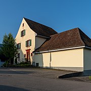
Due to its exposed location on a terrace on the slope of the Thiersteinberg, bordered by two ditches, the Roman Catholic parish church of St. Michael is a landmark of the village. The baroque building was built in 1741 according to plans by the architect Johann Caspar Bagnato , the church tower dates from the late 15th century. The church district also includes the Sigristenhaus and the rectory built between 1760 and 1765. Some buildings from the late 18th and 19th centuries have been preserved in the village center.
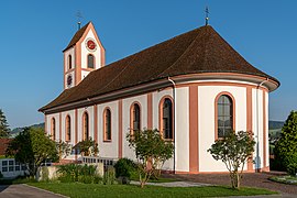
Parish Church of St. Michael
Rectory

Schoolhouse, 1828

Schoolhouse, 1980

Church and gym

village street

Striking farmhouse
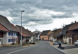
village street


population
The population developed as follows:
| year | 1768 | 1850 | 1900 | 1930 | 1950 | 1960 | 1970 | 1980 | 1990 | 2000 | 2010 | 2015 |
| Residents | 480 | 755 | 591 | 576 | 600 | 607 | 647 | 669 | 834 | 994 | 1081 | 1084 |
On December 31, 2019, 1,046 people lived in Wegenstetten, the proportion of foreigners was 10.7%. In the 2015 census, 53.1% described themselves as Roman Catholic , 18.6% as Reformed and 4.9% as Christian Catholic ; 23.4% were non-denominational or of another faith. In the 2015 census, 95.8% said German as their main language, 1.5% Serbo-Croatian and 1.2% Albanian .
Politics and law
The assembly of those entitled to vote, the municipal assembly , exercises legislative power. The executing authority is the five-member municipal council . He is elected by the people in the majority procedure, his term of office is four years. The parish council leads and represents the parish. To this end, it implements the resolutions of the municipal assembly and the tasks assigned to it by the canton. The Rheinfelden District Court is the first instance responsible for legal disputes . Wegenstetten belongs to the Friedensrichterkreis XIV (Rheinfelden).
economy
According to the company structure statistics (STATENT) collected in 2015, Wegenstetten has around 210 jobs, of which 27% are in agriculture, 17% in industry and 56% in the service sector. Most of the employed people are commuters and work in the larger communities of the Fricktal and in the agglomeration of the city of Basel .
traffic
Wegenstetten can be reached via several local roads. These lead to Möhlin , Eiken and Gelterkinden . The closest connection to the A3 motorway is at Eiken. The connection to the public transport network is provided by two post bus lines . They both have their terminus in Wegenstetten and lead to Möhlin and Gelterkinden. On weekends a night bus runs from Möhlin through the Möhlintal and Fischingertal back to Möhlin.
education


The community has two kindergartens and two schoolhouses in which the primary and secondary schools are taught. The secondary school and the district school can be attended in Möhlin . On the basis of an inter-cantonal agreement, young people from parts of the Fricktal can complete high school in Muttenz ( Canton Basel-Landschaft ) or in Basel .
particularities
The small winter sports area Föhrlimatt is located around one kilometer south of Wegenstetten on the northern slope of the «Kei». It includes a 320 meter long ski lift ( platter lift ) that overcomes a height difference of around 60 meters. The 300 meter long ski and snowboard slope has an average of no more than 25% longitudinal and transverse slopes and is therefore one of the easy slopes. It is continuously illuminated and can be driven on at night. A separate 150 meter long slope is available for tobogganing and bobsledding. On the Wegenstetter Fluh there is a lookout point at an altitude of 708 m above sea level.
literature
- Dominik Sauerländer: Wegenstetten. In: Historical Lexicon of Switzerland .
- Edith Hunziker, Peter Hoegger: The art monuments of the canton of Aargau . Ed .: Society for Swiss Art History . Volume IX, Rheinfelden district. Bern 2011, ISBN 978-3-906131-94-8 , pp. 429-439 .
Web links
- Official website of the community of Wegenstetten
- Website with photos of the village, the inhabitants and the surrounding landscape
Individual evidence
- ↑ Cantonal population statistics 2019. Department of Finance and Resources, Statistics Aargau, March 30, 2020, accessed on April 2, 2019 .
- ↑ Cantonal population statistics 2019. Department of Finance and Resources, Statistics Aargau, March 30, 2020, accessed on April 2, 2019 .
- ↑ a b Beat Zehnder: The community names of the canton of Aargau . In: Historical Society of the Canton of Aargau (Ed.): Argovia . tape 100 . Verlag Sauerländer, Aarau 1991, ISBN 3-7941-3122-3 , p. 457-458 .
- ^ National map of Switzerland, sheets 1068 and 1069, Swisstopo.
- ↑ Standard area statistics - municipalities according to 4 main areas. Federal Statistical Office , November 26, 2018, accessed on May 11, 2019 .
- ^ Joseph Galliker, Marcel Giger: Municipal coat of arms of the Canton of Aargau . Lehrmittelverlag des Kantons Aargau, book 2004, ISBN 3-906738-07-8 , p. 311 .
- ↑ Population development in the municipalities of the Canton of Aargau since 1850. (Excel) In: Eidg. Volkszählung 2000. Statistics Aargau, 2001, archived from the original on October 8, 2018 ; accessed on May 11, 2019 .
- ↑ Resident population by religious affiliation, 2015. (Excel) In: Population and Households, Community Tables 2015. Statistics Aargau, accessed on May 11, 2019 .
- ↑ Swiss Federal Census 2000: Economic resident population by main language as well as by districts and municipalities. (Excel) Statistics Aargau, archived from the original on August 10, 2018 ; accessed on May 11, 2019 .
- ↑ circles of justice of the peace. Canton of Aargau, accessed on June 19, 2019 .
- ↑ Statistics of the corporate structure (STATENT). (Excel, 157 kB) Statistics Aargau, 2016, accessed on May 11, 2019 .
- ↑ Föhrlimatt ski lift. Jurapark Aargau , accessed on May 11, 2019 .