
Sisseln
| Sisseln | |
|---|---|
 |
|
| State : |
|
| Canton : |
|
| District : | Laufenburg |
| BFS no. : | 4177 |
| Postal code : | 4334 |
| UN / LOCODE : | CH SIS |
| Coordinates : | 641412 / 267 254 |
| Height : | 292 m above sea level M. |
| Height range : | 289–308 m above sea level M. |
| Area : | 2.52 km² |
| Residents: | 1595 (December 31, 2019) |
| Population density : | 633 inhabitants per km² |
|
Proportion of foreigners : (residents without citizenship ) |
27.1% (December 31, 2019) |
| Website: | www.sisseln.ch |
| Location of the municipality | |
  |
|
Sisseln ( Swiss German : ˈsɪsːlə ) is a municipality in the Swiss canton of Aargau . It belongs to the district of Laufenburg and is located on the Upper Rhine in the center of the Fricktal region , on the border with Germany .
geography
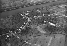
The village is to the east of the confluence of the eponymous river Sissle in the Rhine , on a slightly elevated gravel terrace . The river flows past immediately north of the village center. The largely flat Sisslerfeld, an extensive plain, extends to the east, south and west.
The area of the municipality is 252 hectares , of which 47 hectares are forested and 88 hectares are built over. The highest point is at 306 m above sea level. M. in the forest southeast of the village center, the deepest at 290 m above sea level. M. on the Rhine. Neighboring communities in Switzerland are Stein in the west, Münchwilen in the southwest, Eiken in the south and Kaisten in the east. In the north, Sisseln borders the German communities Bad Säckingen and Murg .
history
To the east of the village there was a fortified Roman building . The building, flanked on both sides by a semicircular tower, was built in the second half of the 4th century and served as a military warehouse. The place name is derived from the Sissle , which in turn comes from the old European Sissila ("the flowing").
Sisseln is one of the youngest villages in the canton. It did not come into being until the second half of the 18th century, when citizens of the Lower Austrian village of Eiken built a development settlement at the mouth of the Sissle . The village initially belonged to the cameraman of Laufenburg . In 1797 the Fricktal became a French protectorate after the Peace of Campo Formio . During the Second Coalition War , the front line between the armies of France and Austria ran here . On February 20, 1802, Sisseln came to the Frick district of the Fricktal canton , which joined the Helvetic Republic in August .
The village has belonged to the canton of Aargau since February 19, 1803. In 1806 Sisseln separated from Eiken and has since formed an independent municipality. The villagers lived from agriculture , fishing and rafting . The last two professional groups mentioned disappeared around 1900 when a hydroelectric power station was built in the neighboring municipality of Stein . On August 1, 1892, the Koblenz – Stein-Säckingen railway was opened . From the beginning of the 1970s, the Basel chemical industry had extensive production facilities built on the Sisslerfeld, and Sisseln transformed into an industrial community on the edge of the agglomeration of the city of Basel . Since then, the population has almost tripled.
Attractions
The simple, late Baroque Roman Catholic chapel dates from 1823 and is dedicated to Saint Fridolin . The three classical stucco marble altars and the stucco cartouche presented by putti on the apex of the choir arch are well worth seeing .

St. Fridolin

inside view

organ


coat of arms
The blazon of the municipal coat of arms reads: "In green and white inclined left river with confluence from the left shield base, in the right upper corner angled three-pronged white fish spear." In 1949 Sisseln did not have its own coat of arms. The village's male choir wanted to buy a new flag at the time and turned to the cantonal coat of arms commission. The two rivers symbolize the Rhine and the Sissle, the Speereisen refers to the earlier salmon catch, the green color stands for the fertility of the Sissleraue.
population
The population developed as follows:
| year | 1803 | 1850 | 1900 | 1930 | 1950 | 1960 | 1970 | 1980 | 1990 | 2000 | 2010 |
| Residents | 233 | 367 | 365 | 287 | 318 | 361 | 475 | 733 | 1160 | 1259 | 1425 |
On December 31, 2019, 1595 people lived in Sisseln, the proportion of foreigners was 27.1%. In the 2015 census, 36.2% described themselves as Roman Catholic and 19.1% as Reformed ; 44.7% were non-denominational or of other faiths. In the 2000 census, 91.9% said their main language was German , 2.4% Italian and 0.9% French .
Politics and law

The assembly of those entitled to vote, the municipal assembly , exercises legislative power. The executing authority is the five-member municipal council . He is elected by the people in the majority procedure, his term of office is four years. The parish council leads and represents the parish. To this end, it implements the resolutions of the municipal assembly and the tasks assigned to it by the canton. The District Court of Laufenburg is the first instance responsible for legal disputes . Sisseln belongs to the Friedensrichterkreis X (Mettau).
| Municipal council | Official title |
|---|---|
| Rainer Schaub | Mayor |
| Kurt Bächtold | Vice-Captain |
| Barbara Hürlimann | Councilor |
| Viviane Raimann | Councilor |
| Jean-Marc Rechsteiner | Municipal council |
economy
According to the corporate structure statistics (STATENT) collected in 2015, Sisseln has around 1000 jobs, of which 1% in agriculture, 76% in industry and 27% in the service sector. In the extensive industrial zone west of the Sissle there are large production facilities for the chemical industry , represented by the companies DSM (formerly Roche ) and Syngenta . Sisseln is the destination of numerous commuters from the surrounding communities as well as the location of the companies Aenova (formerly Temmler ) and Wild .
traffic
Sisseln is well developed in terms of traffic. Hauptstrasse 7 runs through the village between Basel and Winterthur . A connection to the A3 motorway is two kilometers south at Eiken . The connection to the public transport network is provided by a post bus line between the Laufenburg and Stein-Säckingen train stations . On weekends there is a night bus from Frick via Laufenburg to Eiken. The former station at the silo has been closed for a long time, in February 2013 the platforms were dismantled.
education
The community has a kindergarten and a primary school . The district school , the secondary school and the Realschule can be attended in the Blauen school center in Laufenburg . The closest grammar schools are in Aarau ( old canton school and new canton school ); Due to an intercantonal agreement, young people from parts of the Fricktal can also complete the grammar school in Muttenz ( Canton Basel-Landschaft ) or in Basel .
Web links
- Official website of the municipality of Sisseln
- Dominik Sauerländer: Sisseln. In: Historical Lexicon of Switzerland .
Individual evidence
- ↑ Cantonal population statistics 2019. Department of Finance and Resources, Statistics Aargau, March 30, 2020, accessed on April 2, 2019 .
- ↑ Cantonal population statistics 2019. Department of Finance and Resources, Statistics Aargau, March 30, 2020, accessed on April 2, 2019 .
- ↑ a b Beat Zehnder: The community names of the canton of Aargau . In: Historical Society of the Canton of Aargau (Ed.): Argovia . tape 100 . Verlag Sauerländer, Aarau 1991, ISBN 3-7941-3122-3 , p. 239-241 .
- ^ National map of Switzerland, sheet 1049, Swisstopo.
- ↑ Standard area statistics - municipalities according to 4 main areas. Federal Statistical Office , November 26, 2018, accessed on May 11, 2019 .
- ^ Martin Hartmann, Hans Weber: The Romans in Aargau . Verlag Sauerländer, Aarau 1985, ISBN 3-7941-2539-8 , p. 200 .
- ^ Joseph Galliker, Marcel Giger: Municipal coat of arms of the Canton of Aargau . Lehrmittelverlag des Kantons Aargau, book 2004, ISBN 3-906738-07-8 , p. 278 .
- ↑ Population development in the communes of the Canton of Aargau since 1850. (Excel) (No longer available online.) In: Eidg. Volkszählung 2000. Statistics Aargau, 2001, archived from the original on October 8, 2018 ; accessed on May 8, 2019 .
- ↑ Resident population by religious affiliation, 2015. (Excel) In: Population and Households, Community Tables 2015. Statistics Aargau, accessed on May 11, 2019 .
- ↑ Swiss Federal Census 2000: Economic resident population by main language as well as by districts and municipalities. (Excel) (No longer available online.) Statistics Aargau, archived from the original on August 10, 2018 ; accessed on May 9, 2019 .
- ↑ circles of justice of the peace. Canton of Aargau, accessed on June 19, 2019 .
- ↑ Statistics of the corporate structure (STATENT). (Excel; 157 kB) Statistics Aargau, 2016, accessed on May 9, 2019 .
Eiken | Frick | Goose singing | Gipf-Oberfrick | Herznach | Hornussen | Kaisten | Laufenburg | Mettauertal | Münchwilen | Oberhof | Oeschgen | Rake hole | Armchairs | Ueken | Wittnau | Wölflinswil | Draw
Former municipalities: Etzgen | Ittenthal | Mettau | Oberhofen | Sulz | Wil
Canton of Aargau | Districts of the Canton of Aargau | Municipalities in the Canton of Aargau