
Etzgen
| Etzgen | ||
|---|---|---|
 |
||
| State : |
|
|
| Canton : |
|
|
| District : | Laufenburg | |
| Residential municipality : | Mettauertal | |
| Postal code : | 5275 | |
| former BFS no. : | 4162 | |
| Coordinates : | 650 604 / 269 073 | |
| Height : | 330 m above sea level M. | |
| Residents: | 426 (Dec. 31, 2009) | |
|
Proportion of foreigners : (residents without citizenship ) |
17.6% (Dec 31, 2009) | |
| map | ||
|
||


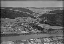
Etzgen ( Swiss German Ätzge [ ˈætsɡə ]) is a village in the Swiss canton of Aargau . It is located on the Upper Rhine on the border with Germany , in the northeast of the Fricktal region . Until the end of 2009 Etzgen formed an independent community in the Laufenburg district , since then it has been one of five villages in the newly created community of Mettauertal .
geography
The village is the lowest in the Mettauertal, not far from the mouth of the Etzgerbach into the Rhine . The village center is located on a raised terrace on the southern slope of the Ebni ( 505 m above sea level ). The Froholz ( 450 m above sea level ) rises south of the village . Both hills belong to the edge zone of the Table Jura ; while they rise rather steeply in the lower area, in the upper area they merge into flatter rising plateaus. The otherwise narrow bank strip along the Rhine expands north of the mouth of the Etzgerbach to a 500 meter wide plain; there is also a small industrial zone here.
The area of the former municipal area was 328 hectares, of which 167 hectares were forested and 37 hectares were built over. The highest point was at 505 meters on the Ebni plateau, the lowest at 300 meters on the Rhine. Neighboring communities were Schwaderloch in the northeast, Mettau in the east, Oberhofen in the southeast and Sulz in the southwest. Etzgen bordered in the north and in the west on the German communities Albbruck and Laufenburg (Baden) .
history
The area around Etzgen was settled as early as the Neolithic , as the discovery of a 5000 year old stone ax shows. In the 4th century the Rhine formed the northern border ( Danube-Iller-Rhein-Limes ) of the Roman Empire . According to a stone tablet that was excavated during the construction of the railway in 1892, the Legio VIII Augusta built three watchtowers in 371, of which, however, no traces have been preserved. Around 400 the Romans finally withdrew across the Alps. Soon after, the Alemanni settled the region.
Eczken was first mentioned in a document relatively late in 1448. The place name is derived from the Old High German Ezzinghofun and means "at the farms of the Ezzo clan". The largest landowner was the noble women's monastery in Bad Säckingen . The sovereignty of the area lay with the House of Habsburg-Laufenburg until 1386 and then passed to the older line of the Habsburgs . After the Waldshut War of 1468, they pledged the entire Fricktal to Burgundy . When the Burgundians were defeated by the Confederates during the Burgundian Wars , Etzgen came under Austrian rule again in 1477.
After the imperial reform of the Austrian Emperor Maximilian I in 1491, Etzgen belonged to Upper Austria and was part of the Laufenburg cameramen . During the Swabian War of 1499, farmers from the Mettauertal plundered the villages in the neighboring Bernese Aargau . In the 17th century there were hardly any longer times of peace. The Rappenkrieg , a peasant uprising, lasted from 1612 to 1614. The Thirty Years War , which also affected the Fricktal between 1633 and 1638, threw the village back in its economic development. Foreign troops also moved through the region during the War of the Palatinate Succession (1688–1697).
In 1797 the Fricktal became a French protectorate after the Peace of Campo Formio . During the Second Coalition War , the front line between the armies of France and Austria ran here . The canton of Fricktal was founded on February 20, 1802 and joined the Helvetic Republic in August ; with that Etzgen had become Swiss. The village belonged together with Oberhofen and Wil to the municipality of Mettau in the Laufenburg district . Etzgen has belonged to the canton of Aargau since March 19, 1803. In 1833 Mettau was separated and an independent community was formed.
After the valley floor was dumped around 1860, the settlement spread to the Rhine. On August 21, 1869, a major fire raged in the village, leaving 121 people (almost half of the population) homeless. After the Koblenz – Stein-Säckingen railway line opened on August 1, 1892, smaller industrial companies settled here. Nonetheless, Etzgen remained predominantly agricultural until well into the 20th century, and from around 1950 onwards it became a residential community.
On March 20, 2008, the community assembly decided to merge Etzgen with Hottwil , Mettau, Oberhofen and Wil to form the Mettauertal community . The ballot box on June 1, 2008 was also in favor of a merger. The merger took place on January 1, 2010.
coat of arms
The blazon of the former municipality and today's village coat of arms reads: "In blue over three white waves, yellow ferry, raised by a five-pointed white star." The coat of arms was only introduced in 1953, when a ferry was chosen as the motif. This connection across the Rhine has been handed down since at least 1448. In 1983 the municipal council set the number of waves to be three.
With effect from January 1, 2010 the coat of arms was canceled.
population
Population development:
| year | 1850 | 1900 | 1930 | 1950 | 1960 | 1970 | 1980 | 1990 | 2000 |
| Residents | 315 | 256 | 252 | 271 | 279 | 323 | 319 | 362 | 350 |
On December 31, 2008, 431 people lived in Etzgen, the proportion of foreigners was 18.8%. At the 2000 census, 63.4% were Roman Catholic, 22.9% Reformed, and 2.6% Muslim; 3.1% belonged to other faiths. 91.4% named German as their main language, 2.0% Albanian, 1.4% Italian.
Attractions
- Bruderklausen Chapel, built in 1948

Bünten school building

Brother Clause Chapel

Window in the chapel

Housing estate, Dorfstrasse

village street

Dorfstrasse / Bergstrasse


traffic
Hauptstrasse 7 runs along the Rhine between Basel and Winterthur . In the industrial zone, a cantonal road branches off, which leads via Mettau and the Bürersteig in the direction of Brugg . The connection to the public transport network is provided by two post bus lines that run from Laufenburg train station to Brugg and Döttingen . The railway line between Laufenburg and Koblenz has been closed for passenger traffic since May 28, 1994.
Web links
- Dominik Sauerländer: Etzgen. In: Historical Lexicon of Switzerland .
- Etzgen on mettauertal.ch
Individual evidence
- ↑ a b Beat Zehnder: The community names of the canton of Aargau . In: Historical Society of the Canton of Aargau (Ed.): Argovia . tape 100 . Verlag Sauerländer, Aarau 1991, ISBN 3-7941-3122-3 , p. 148-150 .
- ^ National map of Switzerland, sheet 1049, Swisstopo
- ^ Martin Hartmann, Hans Weber: The Romans in Aargau . Verlag Sauerländer, Aarau 1985, ISBN 3-7941-2539-8 , p. 168 .
- ↑ The new Mettauertal community passed its democratic baptism of fire. fricktal24.ch, November 30, 2009, accessed on September 6, 2012 .
- ^ Joseph Galliker, Marcel Giger: Municipal coat of arms of the canton of Aargau . Lehrmittelverlag des Kantons Aargau, book 2004, ISBN 3-906738-07-8 , p. 153 .
- ↑ Coat of arms register of the municipalities of Aargau , repealed municipal coat of arms since 2003, accessed on April 23, 2012.
- ↑ Population development in the municipalities of the Canton of Aargau since 1850. (Excel) In: Eidg. Volkszählung 2000. Statistics Aargau, 2001, archived from the original on October 8, 2018 ; accessed on May 8, 2019 .
- ↑ Swiss Federal Census 2000: Economic resident population by religious affiliation as well as by districts and municipalities. (Excel) Statistics Aargau, archived from the original on August 10, 2018 ; accessed on May 8, 2019 .
- ↑ Swiss Federal Census 2000: Economic resident population by main language as well as by districts and municipalities. (Excel) Statistics Aargau, archived from the original on August 10, 2018 ; accessed on May 8, 2019 .
Eiken | Frick | Goose singing | Gipf-Oberfrick | Herznach | Hornussen | Kaisten | Laufenburg | Mettauertal | Münchwilen | Oberhof | Oeschgen | Rake hole | Armchairs | Ueken | Wittnau | Wölflinswil | Draw
Former municipalities: Etzgen | Ittenthal | Mettau | Oberhofen | Sulz | Wil
Canton of Aargau | Districts of the Canton of Aargau | Municipalities in the Canton of Aargau