
Wil AG
| AG is the abbreviation for the canton of Aargau in Switzerland and is used to avoid confusion with other entries of the name Wil . |
| Wil | ||
|---|---|---|
 |
||
| State : |
|
|
| Canton : |
|
|
| District : | Laufenburg | |
| Residential municipality : | Mettauertal | |
| Postal code : | 5276 | |
| former BFS no. : | 4180 | |
| Coordinates : | 653 801 / 267 966 | |
| Height : | 375 m above sea level M. | |
| Area : | 7.71 km² | |
| Residents: | 674 (Dec. 31, 2009) | |
| Population density : | 87 inhabitants per km² | |
|
Proportion of foreigners : (residents without citizenship ) |
8.9% (Dec 31, 2009) | |
| map | ||
|
||


Wil ( Swiss German : ʋiːl ) is a village in the Swiss canton of Aargau . It is located in the northeast of the Fricktal region . Until the end of 2009 Wil formed an independent community in the Laufenburg district , since then it has been one of five villages in the newly created community of Mettauertal .
geography
The over one kilometer long street village is located on the Etzgerbach in the upper Mettauertal. The narrow valley is bordered on both sides by hills of the Table Jura , which rise steeply in the lower area and then merge into flatter rising plateaus. The Etzgerbach changes its direction of flow from north to west in the village center. In the south rises the Runifirst ( 495 m above sea level ), in the southwest of the Rotenberg ( 485 m above sea level ). The narrow ridge of the Egghalde and the Weisstannenkopf (both 566 m above sea level ) runs in the north-west, while the summit of the Ebnet rises to the north ( 535 m above sea level ). Near the eastern border of the municipality, the Weisstannenkopf and the Ebnet unite to form an extensive plateau that is used for agriculture. In the south-east the terrain rises to the upper Rüti ( 605 m above sea level ). The hamlet of Ödenholz ( 521 m above sea level ) is located on the Ebnet plateau, and the hamlet of Egg ( 450 m above sea level ) on the southern slope of the Egghalde .
The area of the former municipal area was 771 hectares, of which 238 hectares were forested and 41 hectares were built over. The highest point in the municipality was just below the summit of the Upper Rüti at 600 meters, the deepest point at 355 meters on the Etzgerbach. Neighboring communities were Schwaderloch in the northwest, Leibstadt in the northeast, Leuggern and Mandach in the east, Hottwil in the southeast, Gansingen in the south, Oberhofen in the southwest and Mettau in the west.
history
Various finds suggest a settlement by the Romans ; it is believed that the name Wil comes from the name villa . Around 400 the Romans finally withdrew across the Alps. Around a hundred years later, the Alemanni settled the area. The first documentary mention was made in 1318, the place name comes from the Old High German wilari and denotes a court settlement without further details of ownership. The largest landowner was the aristocratic Säckingen monastery . The sovereignty of the area lay with the Counts of Habsburg-Laufenburg until 1386 and then passed to the older line of the Habsburgs . After the Waldshut War of 1468, they pledged the entire Fricktal to Burgundy . When the Burgundians were defeated by the Confederates during the Burgundian Wars , Etzgen came under Austrian rule again in 1477.
After the imperial reform of the Austrian Emperor Maximilian I in 1491, Wil belonged to the front of Austria and was part of the cameramen of Laufenburg . The village bordered both the Bernese Aargau and the county of Baden . During the Swabian War of 1499, farmers from the Mettauertal plundered the villages in the neighboring Bernese Aargau. In the 17th century there were hardly any longer times of peace. The Rappenkrieg , a peasant uprising, lasted from 1612 to 1614. The Thirty Years War , which also affected the Fricktal between 1633 and 1638, threw the village back in its economic development. Foreign troops also moved through the region during the War of the Palatinate Succession (1688–1697).

In 1797 the Fricktal became a French protectorate after the Peace of Campo Formio . During the Second Coalition War , the front line between the armies of France and Austria ran here ; at Wil there was a French military camp. The canton of Fricktal was founded on February 20, 1802 and joined the Helvetic Republic in August ; with that Wil had become Swiss. The village belonged together with Etzgen and Oberhofen to the municipality of Mettau in the Laufenburg district .
Since March 19, 1803 Wil has belonged to the canton of Aargau; in the same year the village of Mettau broke up and formed an independent municipality. Between 1850 and 1900 the population decreased by almost 30 percent. Many residents were impoverished and had to leave their home village. The community organized and financed immigration to North America in numerous cases. Wil remained dominated by agriculture well into the 20th century, and the population stagnated for decades. Due to the conversion to a residential community, it has increased again slightly since the beginning of the 1980s.
On March 20, 2008, the community assembly decided to merge Wil with Etzgen, Hottwil , Mettau and Oberhofen to form the Mettauertal community . The ballot box on June 1, 2008 was also in favor of a merger. The merger took place on January 1, 2010.
coat of arms
The blazon of the former municipality and today's village coat of arms reads: "Divided by yellow with a growing red lion and by green with three five-pointed white stars." The coat of arms was introduced in 1950. The lion's trunk is reminiscent of the rule of the Counts of Habsburg-Laufenburg, the three stars symbolize the towns of Wil, Ödenholz and Egg.
population
Population development:
| year | 1850 | 1900 | 1930 | 1950 | 1960 | 1970 | 1980 | 1990 | 2000 |
| Residents | 739 | 521 | 522 | 533 | 558 | 539 | 530 | 566 | 666 |
On December 31, 2008, 659 people lived in Wil, the proportion of foreigners was 9.0%. At the 2000 census, 70.4% were Roman Catholic and 17.3% were Reformed; 1.4% belonged to other faiths. 97.1% said German was their main language.
Attractions

school

gym
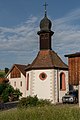
St. Wendelin's Chapel

Old house, Trottenstrasse

Mitteldorfstrasse
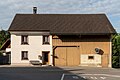
Typical farmhouse


traffic
The village is located away from the larger thoroughfares, the main access is from Etzgen . This road continues over the Bürersteig to Remigen and finally to Brugg . Another road leads over Ödenholz to Leuggern . Wil is connected to the public transport network by the Brugg– Laufenburg post bus line.
Personalities
- Manuela "Manou" Oeschger (born February 18, 1984), singer in the band beFour
Web links
- Dominik Sauerländer: Wil AG. In: Historical Lexicon of Switzerland .
- Wil on mettauertal.ch
Individual evidence
- ↑ a b Beat Zehnder: The community names of the canton of Aargau . In: Historical Society of the Canton of Aargau (Ed.): Argovia . tape 100 . Verlag Sauerländer, Aarau 1991, ISBN 3-7941-3122-3 , p. 463-464 .
- ^ National map of Switzerland, sheet 1049, Swisstopo
- ↑ Aargauer Zeitung : Five clear yeses to the merger, March 21, 2008.
- ^ Joseph Galliker, Marcel Giger: Municipal coat of arms of the canton of Aargau . Lehrmittelverlag des Kantons Aargau, book 2004, ISBN 3-906738-07-8 , p. 314 .
- ↑ Population development in the municipalities of the Canton of Aargau since 1850. (Excel) In: Eidg. Volkszählung 2000. Statistics Aargau, 2001, archived from the original on October 8, 2018 ; accessed on May 8, 2019 .
- ↑ Swiss Federal Census 2000: Economic resident population by religious affiliation as well as by districts and municipalities. (Excel) Statistics Aargau, archived from the original on August 10, 2018 ; accessed on May 8, 2019 .
- ↑ Swiss Federal Census 2000: Economic resident population by main language as well as by districts and municipalities. (Excel) Statistics Aargau, archived from the original on August 10, 2018 ; accessed on May 8, 2019 .
Eiken | Frick | Goose singing | Gipf-Oberfrick | Herznach | Hornussen | Kaisten | Laufenburg | Mettauertal | Münchwilen | Oberhof | Oeschgen | Rake hole | Armchairs | Ueken | Wittnau | Wölflinswil | Draw
Former municipalities: Etzgen | Ittenthal | Mettau | Oberhofen | Sulz | Wil
Canton of Aargau | Districts of the Canton of Aargau | Municipalities in the Canton of Aargau