
Mettau
| Mettau | ||
|---|---|---|
 |
||
| State : |
|
|
| Canton : |
|
|
| District : | Laufenburg | |
| Residential municipality : | Mettauertal | |
| Postal code : | 5274 | |
| former BFS no. : | 4171 | |
| Coordinates : | 651 812 / 268 350 | |
| Height : | 346 m above sea level M. | |
| Residents: | 301 (Dec. 31, 2009) | |
|
Proportion of foreigners : (residents without citizenship ) |
10.0% (Dec 31, 2009) | |
| map | ||
|
||


Mettau (in the local dialect Mätteb, ˈmætːəb ) is a village in the Swiss canton of Aargau . It is located in the northeast of the Fricktal region . Until the end of 2009, Mettau was an independent community in the Laufenburg district , and since then it has been one of five villages in the newly created community of Mettauertal .
geography
The village is located in the lower part of the Mettauertal, at a point where the otherwise rather narrow valley widens a little. The Mettauerbach flows into the Etzgerbach a little to the east of the village center ; the latter flows into the Upper Rhine after two and a half kilometers . The valley is bordered on both sides by hills of the Table Jura , which rise steeply in the lower area and then merge into flatter, rising plateaus.
In the north is the largely agricultural area, which is an average of 120 meters above the valley floor; viticulture is carried out on its flank . The plain extends over a kilometer in a northerly direction to the Ischlag ( 508 m above sea level ) and then drops steeply to the Rhine; in the east it is bounded by the narrow ridge of the Egghalde ( 566 m above sea level ). On the other side of the valley, the municipality extends on the steep northern slope of the Meiershalde, up to a height of around 450 m above sea level. M.
The area of the former municipality was 329 hectares, of which 178 hectares were forested and 15 hectares were built over. The highest point in the municipality at 555 meters on the Egghalde, the lowest point at 325 meters on the Etzgerbach. Neighboring communities were Schwaderloch in the north, Wil in the east, Oberhofen in the south and Etzgen in the west.
history
A gold coin minted in Thessaloniki during the reign of Constantine the Great , which was found in Mettau in 1922, indicates that there was a route from Vindonissa through the Mettauertal to the Rhine during Roman times . Mettowe was first mentioned in a document in 1254. The place name is derived from the Old High German metamun ouwo and means "in the land near the water".
The village formed the center of a court district and a Dinghof that was owned by the aristocratic Säckingen monastery . It emerged from an earlier clearing association and covered the entire Mettauertal with the exception of Gansingen . The sovereignty of the area lay with the Counts of Habsburg-Laufenburg until 1386 and then passed to the older line of the Habsburgs . After the Waldshut War of 1468, they pledged the entire Fricktal to Burgundy . When the Burgundians were defeated by the Confederates during the Burgundian Wars , Mettau came under Austrian rule again in 1477.

After the imperial reform of the Austrian Emperor Maximilian I in 1491, Mettau belonged to Upper Austria and was part of the Laufenburg cameramen . During the Swabian War of 1499, farmers from the Mettauertal plundered the villages in the neighboring Bernese Aargau . In the 17th century there were hardly any longer times of peace. The Rappenkrieg , a peasant uprising, lasted from 1612 to 1614. The Thirty Years War , which also affected the Fricktal between 1633 and 1638, threw the village back in its economic development. Foreign troops also moved through the region during the War of the Palatinate Succession (1688–1697).
In 1797 the Fricktal became a French protectorate after the Peace of Campo Formio . During the Second Coalition War , the front line between the armies of France and Austria ran here . The canton of Fricktal was founded on February 20, 1802 and joined the Helvetic Republic in August ; with that Mettau had become Swiss. The community was then part of the Laufenburg district. After the unification of the Fricktal with the canton of Aargau on March 19, 1803, the large community of Mettau shrank because the individual villages separated and formed independent communities: Wil started in 1803, followed by Oberhofen in 1832 and finally Etzgen in 1833 . Most of the village was destroyed by a devastating fire in 1827.
Mettau remained dominated by agriculture until well into the 20th century. Between 1900 and 1980 the population decreased by 20 percent, since then it has increased again slightly. On March 20, 2008, the community assembly decided to merge Mettau with Etzgen , Hottwil , Oberhofen and Wil to form the Mettauertal community . The ballot box on June 1, 2008 was also in favor of a merger. The merger took place on January 1, 2010.
coat of arms
The blazon of the former municipality and today's village coat of arms reads: "Divided by red with a growing yellow lion and by white with a torn five-leaved green linden tree." The coat of arms was introduced in 1924. The lion's trunk indicates the earlier rule of the Counts of Habsburg-Laufenburg. In the lower part of the coat of arms the family tree of the ruling house was depicted, but this is not permitted according to the rules of heraldry . The local council therefore replaced it in 1953 with the five-leaved linden tree.
population
Population development:
| year | 1850 | 1900 | 1930 | 1950 | 1960 | 1970 | 1980 | 1990 | 2000 | 2009 |
| Residents | 387 | 302 | 272 | 270 | 270 | 251 | 242 | 264 | 301 | 301 |
On December 31, 2009, 301 people lived in Mettau, the proportion of foreigners was 7.6%. At the 2000 census, 70.8% were Roman Catholic and 17.9% were Reformed; 2.3% belonged to other faiths. 97.7% said German was their main language.
Attractions
The parish church of St. Remigius was built from 1773 to 1776 in the late Baroque style. The tower was taken over from the previous church from 1670. The house stone that was used for the construction comes from the quarry in Oberhofen . The rubble stones were cut in the Kienzen. The interior was decorated with frescoes by Franz Fidel Bröchin and stucco work by Luzius Gams. The altars and the pulpit are made of marbled wood.

Parish Church of St. Remigius 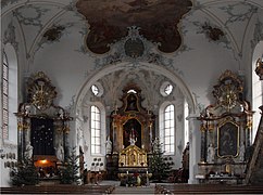
Interior of the church 
Central administration of the Mettauertal community

gym

Main road

Typical farmhouses


traffic
Mettau is on Kantonsstrasse 277, which leads from the Rhine Valley near Etzgen over the Bürersteig to Brugg . Kantonsstrasse 444 branches off to the east of the village; this runs via Wil and Hottwil to the Bürersteig, where it meets the main connecting road again. The connection to the public transport network is provided by a post bus line between the Laufenburg and Brugg train stations . The village is connected to a well-developed network of hiking trails and is also passed by the Flösserweg . Mettau is the starting point and destination of the Fricktaler Höhenweg .
Web links
- Dominik Sauerländer: Mettau. In: Historical Lexicon of Switzerland .
- Mettau on mettauertal.ch
Individual evidence
- ↑ a b Beat Zehnder: The community names of the canton of Aargau . In: Historical Society of the Canton of Aargau (Ed.): Argovia . tape 100 . Verlag Sauerländer, Aarau 1991, ISBN 3-7941-3122-3 , p. 272-273 .
- ↑ a b National map of Switzerland, sheet 1049, Swisstopo
- ^ Martin Hartmann, Hans Weber: The Romans in Aargau . Verlag Sauerländer, Aarau 1985, ISBN 3-7941-2539-8 , p. 182 .
- ↑ Aargauer Zeitung : Five clear yeses to the merger, March 21, 2008.
- ^ Joseph Galliker, Marcel Giger: Municipal coat of arms of the canton of Aargau . Lehrmittelverlag des Kantons Aargau, book 2004, ISBN 3-906738-07-8 , p. 214 .
- ↑ Population development in the municipalities of the Canton of Aargau since 1850. (Excel) In: Eidg. Volkszählung 2000. Statistics Aargau, 2001, archived from the original on October 8, 2018 ; accessed on May 8, 2019 .
- ↑ Swiss Federal Census 2000: Economic resident population by religious affiliation as well as by districts and municipalities. (Excel) Statistics Aargau, archived from the original on August 10, 2018 ; accessed on May 8, 2019 .
- ↑ Swiss Federal Census 2000: Economic resident population by main language as well as by districts and municipalities. (Excel) Statistics Aargau, archived from the original on August 10, 2018 ; accessed on May 8, 2019 .
- ^ Heinz Fricker, Thomas Freivogel: Parish Church of St. Remigius Mettau AG. (Swiss Art Guide, No. 365). Ed. Society for Swiss Art History GSK. Bern 1984, ISBN 978-3-85782-365-7 .
Eiken | Frick | Goose singing | Gipf-Oberfrick | Herznach | Hornussen | Kaisten | Laufenburg | Mettauertal | Münchwilen | Oberhof | Oeschgen | Rake hole | Armchairs | Ueken | Wittnau | Wölflinswil | Draw
Former municipalities: Etzgen | Ittenthal | Mettau | Oberhofen | Sulz | Wil
Canton of Aargau | Districts of the Canton of Aargau | Municipalities in the Canton of Aargau