
Frenke (river)
|
Frenke Front Frenke |
||
 Stone bridge over the Frenke in Liestal |
||
| Data | ||
| Water code | CH : 6 | |
| location |
law
|
|
| River system | Rhine | |
| Drain over | Ergolz → Rhine → North Sea | |
| source | at Bilsteinberg 47 ° 21 ′ 9 ″ N , 7 ° 44 ′ 49 ″ E |
|
| Source height | approx. 820 m above sea level M. | |
| muzzle | in Liestal in Ergolz Coordinates: 47 ° 28 '51 " N , 7 ° 44' 46" E ; CH1903: 623.18 thousand / 258 953 47 ° 28 '51 " N , 7 ° 44' 46" O |
|
| Mouth height | approx. 312 m above sea level M. | |
| Height difference | approx. 508 m | |
| Bottom slope | approx. 27 ‰ | |
| length | 18.7 km | |
| Catchment area | 88.4 km² | |
| Discharge A Eo : 88.4 km² |
MQ Mq |
1.31 m³ / s 14.8 l / (s km²) |
| Small towns | Liestal | |
The Frenke is a left tributary of the Ergolz in the Swiss canton of Basel-Landschaft . Up to the confluence of the Hinteren Frenke , the river is also called the Vordere Frenke . The river has its source in the Folded Jura and flows through the Waldenburgertal in an approximately north-northwest direction . The Frenke is 18.7 km long.
geography
course
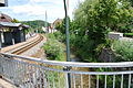
The Frenke rises on the Bilsteinberg in the municipality of Langenbruck and flows quickly to the pass road of the Upper Hauenstein , which was already used by the Romans . Then it flows along the pass road through the medieval town of Waldenburg , where the terminus of the Waldenburgerbahn is located.
It then flows through the villages of Oberdorf , Niederdorf and Hölstein and Bubendorf , where the Hintere Frenke joins from the left. After continuing to the north, it finally flows into the Ergolz in Liestal .

Front Frenke near Waldenburg
Niederdorf
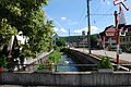
Hölstein


Tributaries
- Weigistbach, from the left in Oberdorf
- Bennwilerbach, from the right in Hölstein
- Talbächli, from the left to Hölstein
- Hintere Frenke, from the left near Bubendorf
use
The textile company Hanro built a canal next to the Frenke in Liestal to generate electricity.
Web links
- Fish fauna Frenke - inventory 2018
- Frenken - Biological Investigation 2000/2001
- The Frenken - a description of the state
Individual evidence
- ↑ a b c Geoserver of the Swiss Federal Administration ( information )
- ↑ a b Modeled mean annual discharge. In: Topographical catchment areas of Swiss waters: area outlets. Retrieved May 4, 2018 .
- ^ Bulletin of September 2009, p . 18 - Canton of Basel-Landschaft