
Langenbruck
| Langenbruck | |
|---|---|
 |
|
| State : |
|
| Canton : |
|
| District : | Waldenburg |
| BFS no. : | 2888 |
| Postal code : | 4438 |
| Coordinates : | 624 974 / 244 235 |
| Height : | 700 m above sea level M. |
| Height range : | 631–1125 m above sea level M. |
| Area : | 15.66 km² |
| Residents: | 958 (December 31, 2018) |
| Population density : | 61 inhabitants per km² |
| Website: | www.langenbruck.ch |
 Langenbruck |
|
| Location of the municipality | |
  |
|
Langenbruck is a municipality in the Waldenburg district of the canton of Basel-Landschaft in Switzerland .
geography

Langenbruck, border municipality to the canton of Solothurn , lies in the upper valley section of the Augstbach, which drains the area south of the watershed towards the Dünnern . It is separated from Waldenburgertal by the top of the pass at Oberen Hauenstein ( 734 m above sea level ). With an average altitude of 704 meters above sea level. M. Langenbruck is the highest municipality in the canton of Baselland.
The community borders in the west and north on Waldenburg , in the north on Oberdorf and Bennwil , in the north and east on Eptingen . Along the cantonal border between Baselland and Solothurn, Langenbruck borders Mümliswil-Ramiswil to the west and south , Holderbank SO and Egerkingen to the south and Hägendorf to the east .
history
Langenbruck, in dialect "Langebrugg", was first mentioned in 1145 as Villa Langebruccho . The story of the pass crossing began when the Romans expanded the route to a permanent road because it had become important as a connection between the cities of Aventicum and Augusta Raurica . A road made of round timber, which was found during excavations in 1935, led through the swampy terrain near Langenbruck. The construction served to bring carters, draft animals and carts better over the muddy ground. This is why this section of the route was given the name "Long Bridge".
The place name is mentioned for the first time in a letter from Count Ludwig von Frohburg to the monks in Schönthal Monastery in 1145 . Later it appears in other documents of the Counts of Frohburg and other exhibitors with different spellings: Langebruccho, Langenbrucke, Langenbrucche, Langenbrugge, Langenbrugke, Langenbrug, Langenburg, Langenbrugg, 1422 as Langenbrugk in a document in which the sovereign rights of the rule Waldenburg are notarized . Heinrich Hänger mentions the name in Old High German as Langun-bruggu.
Langenbruck used to be a climatic health resort mainly for guests from Basel. The place was known for ski jumping on the Erzenbergschanze and later on the Freichelen ski jumping hills . Today there are still ski lifts and cross-country skiing trails in Bärenwil. A network of hiking trails over 100 kilometers in length has been laid out in the area.
The monastery Schönthal , founded by Count Adalbero of Frohburg dating back to 1145, has the oldest preserved Romanesque portal in Switzerland.
politics
The legislature of the community forms the formed by all adult citizens Municipal Assembly .
The executive is formed by the five-member municipal council. The council is the mayor before, at the time Hector Herzig ( glp , Booth 2016).
Attractions
Hamlet of Bärenwil
In the southern municipality, immediately bordering the canton of Solothurn (Solothurn municipalities Hägendorf , Egerkingen and Holderbank ), lies at 778 m above sea level. M. the hamlet of Bärenwil; this belongs to the political municipality Langenbruck. Bärenwil was first mentioned in a document in 1226. The hamlet consists of 11 houses with a total of about 50 inhabitants. There are two courtyards in the immediate vicinity, namely the “Gotterbarm” and the “Leimen”. The "Buchmatt" immediately east of Bärenwil is already in the canton of Solothurn. In the area near Bärenwil - across all cantons - a total of three outer courtyards have disappeared since 1872, namely the Egerking "Stierenweid" due to fire in January 1872, the Hägendörfer "Müllersbergli" demolished after 1876, and the Langenbrucker "Spalen" demolished in 1963.

Today there is only one actively managed farm in the hamlet itself. Bärenwil also has a restaurant called “Chilchli”. On the gable is a small bell tower with a bell weighing about 100 kg. This was given to the Bärenwil residents in 1833 by the city of Basel after the turmoil surrounding the separation of the cantons because of Bärenwil's loyalty to the city. The "Chilchli" has a clock with a striking dial on the western front of the building.
A painter of Jura landscapes, village views and courtyards who was known locally and historically was Albert Schweizer (1885–1948) from Bärenwil .
Side roads lead from Bärenwil over the mountain ranges of the Jura (including Santelhöchi ) to Egerkingen resp. Hägendorf. In the event of a traffic jam on the A2 motorway ( Belchentunnel ), Bärenwil is therefore affected by crawl traffic . Bärenwil currently has no connection to public transport.

coat of arms
The coat of arms is a young creation. It was approved by the community assembly on March 5, 1939. The Agnus Dei (Lamb of God), like Bennwil's coat of arms , is reminiscent of the former Schönthal monastery . The symbol of the lamb does not correspond to the old monastery coat of arms (the patron saint was St. Mary), but it appears in 1225 in the seal of the Benedictine monastery provost. It also adorns the baptismal bowl from Schönthal Abbey , which is located in Bennwil's church. The old street is remembered with the stylized "long bridge". The colors of the coat of arms emphasize the former affiliation to the Frohburg rule .
Personalities
- Martin Bider (1812–1878), physician, politician and main initiator of the Waldenburgerbahn
- Oskar Bider (1891-1919), aviation pioneer
- Julie Helene Bider , (1894–1919), first Baselbiet film actress (cf. silent films: "Frühlingsmanöver" and "Der Bergführer")
- Jakob Christ (1926–2008), psychiatrist
- Pierre Graber (1908–2003), Swiss Federal Councilor from 1970–1978
- Heinrich Jenny (1824–1891), draftsman, history painter, illustrator and drawing teacher
- Václav Šprungl (1926–1993), Czech painter and graphic artist
photos

Schöntal with monastery

Schöntal Monastery

Taverns on the pass road

WKA Sool - Switzerland's first grid-connected wind turbine, since 1986

church
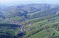
Aerial view


literature
- Axel Christoph Gampp, Sabine Sommerer: The art monuments of the canton Basel-Landschaft IV. The district Waldenburg. (= Art Monuments of Switzerland. Volume 124). Edited by the Society for Swiss Art History , Bern 2014, ISBN 978-3-03797-115-4 .
Web links
- Langenbruck community
- The development of tourism in Langenbruck (PDF file; 810 kB)
- State Archives Basel (aerial photo of Langenbruck from 1932)
- State Archives Basel (photo of the Langenbruck Sanatorium from 1933)
- Beatrice Schumacher : Langenbruck. In: Historical Lexicon of Switzerland .
- Movie, Bider der Flieger
- Film document by Emil Müller (Hotel Erica) from Langenbruck
Individual evidence
- ↑ Permanent and non-permanent resident population by year, canton, district, municipality, population type and gender (permanent resident population). In: bfs. admin.ch . Federal Statistical Office (FSO), August 31, 2019, accessed on December 22, 2019 .
- ^ Ambros Kocher: Solothurn document book . First vol. 762-1245. State Chancellery of the Canton of Solothurn, Solothurn 1952, p. 183-185 .
- ↑ Albert Schweizer. In: Swiss Artist Lexicon. Volume IV, 1917, p. 617.
- ↑ Baselbieter Heimatbuch Volume IV, 1954, pp. 71–79.
- ↑ Biography about Julie Helene Bider in: "Baselbieter Heimatblätter", No. 3/2009 and No. 1/2010 (BHbl; Druck Lüdin AG, 4410 Liestal) .; Biography (PDF) of the current version at "www.oskar-bider-archiv.ch".
- ^ Spring maneuvers , silent film by Charles Decroix , 15 min., 1917
- ↑ Der Bergführer , silent film by Eduard Bienz , 65 min., 1917