
Villnachern
| Villnachern | |
|---|---|
 |
|
| State : |
|
| Canton : |
|
| District : | Brugg |
| BFS no. : | 4122 |
| Postal code : | 5213 |
| Coordinates : | 654388 / 258 043 |
| Height : | 365 m above sea level M. |
| Height range : | 332-574 m above sea level M. |
| Area : | 5.75 km² |
| Residents: | 1655 (December 31, 2019) |
| Population density : | 288 inhabitants per km² |
|
Proportion of foreigners : (residents without citizenship ) |
16.4% (December 31, 2019) |
| Website: | www.villnachern.ch |
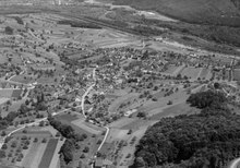
 Villnachern seen from the Habsburg |
|
| Location of the municipality | |
  |
|
Villnachern (the V spoken like an F; Swiss German : ˈfɪlˌnɑχərə ) is a municipality in the Swiss canton of Aargau . It belongs to the Brugg district and is located around three kilometers west-southwest of the district capital.
geography
The village lies in a hollow between the western bank of the Aare and the slopes of the foothills of the Bözberg, which belongs to the Table Jura . In the southwest are caused by a deeply carved ravines separate hill Buech and Grüt. This is followed in the northwest by the valley of the Talbach and finally the main plateau of the Bözberg. The main settlement is at the exit of the Talbachtobel on both sides of the stream. Several individual farms are scattered across the municipality. In this area, the Aare consists of two parallel river arms. These are separated from each other by the approximately four kilometers long and an average of 150 meters wide Schacheninsel, which was created by alluvial debris.
The area of the municipality is 575 hectares , of which 281 hectares are covered with forest and 76 hectares are built over. The highest point is at 572 meters in the Widacher area in the northwest, the deepest at 338 meters on the Aare. Neighboring communities are Bözberg in the north, Brugg in the southeast and Schinznach in the south.
history
Finds from the Neolithic Age indicate an early settlement of this area. In addition, remains of Roman buildings and Alemannic graves were found. Filnacker was first mentioned in 1141 when the St. Blasien monastery sold its property to the Habsburgs . The place name comes from the Old High German (ze) Filin ahharun and means "in the fields of Filo". The name Wilnach appears in the Habsburg land register of 1306 . Later the village came under the rule of Schenkenberg . Villnachern Castle belonged to the Lords of Ostrach from the middle of the 13th century (the family has no recognizable connection with the town of Ostrach in the Allgäu, but a connection with the town of Uster is possible ). This family died out before 1450 and the castle fell into ruin in the second half of the 15th century.
Bern occupied the Schenkenberg rule militarily in 1460 and added it as a new bailiff to the other subject areas in the Bernese Aargau . Villnachern formed its own judicial district within the Landvogtei. In 1528 the Bernese introduced the Reformation and in 1732 assigned the village to the newly formed office of Kasteln . In March 1798 the French took Switzerland, ousted the «Gracious Lords» of Bern and proclaimed the Helvetic Republic . Since then Villnachern has belonged to the canton of Aargau.
During the early modern period, shell limestone and gypsum were mined in quarries. On August 2, 1875, with the opening of the Bözberg line, it was connected to the railway network, but the station was a bit off the slope of the Bözberg. The Villnacherer vineyards once covered an area of over 40 hectares, but fell largely victim to phylloxera in the second half of the 19th century . In the second half of the 20th century, Villnachern changed from a farming community to a residential community. The population increased by over 70 percent between 1970 and 1990 alone.
On April 5, 2009, the voters approved a planned merger with the neighboring communities of Schinznach-Dorf , Schinznach-Bad and Oberflachs to form the new community of Schenkenberg . However, the merger did not materialize because Veltheim rejected it. The subsequently initiated merger project without Veltheim failed in a ballot vote on October 25, 2009, when the voters of Villnachern rejected the project.
Attractions

In the center of the village there are numerous buildings that were built around 1600 in the late Gothic style. Villnachern does not have its own church, but has always been part of the Umiken parish . The tithe house is of national importance in the Swiss inventory of cultural assets .
coat of arms
The blazon of the municipal coat of arms reads: "Yellow ploughshare turned in blue, accompanied by two five-pointed yellow stars in the shield head." The coat of arms appeared in this form for the first time on the municipal seal in 1872. The plow indicates the agricultural tradition of the village, while the meaning of the two stars is no longer known.
population
The population developed as follows:
| year | 1764 | 1850 | 1900 | 1930 | 1950 | 1960 | 1970 | 1980 | 1990 | 2000 | 2010 |
| Residents | 282 | 504 | 421 | 533 | 644 | 716 | 789 | 1056 | 1353 | 1221 | 1497 |
On December 31, 2019, 1655 people lived in Villnachern, the proportion of foreigners was 16.4%. In the 2015 census, 38.1% described themselves as Reformed and 27.1% as Roman Catholic ; 34.8% were non-denominational or of other faiths. In the 2000 census, 92.0% stated German as their main language, 1.1% each Italian and French and 0.8% Serbo-Croatian .
Politics and law
The assembly of those entitled to vote, the municipal assembly , exercises legislative power. The executing authority is the five-member municipal council . He is elected by the people in the majority procedure, his term of office is four years. The parish council leads and represents the parish. To this end, it implements the resolutions of the municipal assembly and the tasks assigned to it by the canton. The Brugg District Court is the first instance responsible for legal disputes . Villnachern belongs to the Friedensrichterkreis VIII (Brugg).
economy
According to the company structure statistics (STATENT) collected in 2015, Villnachern has around 260 jobs, 15% of them in agriculture, 33% in industry and 52% in the service sector. Thus Villnachern is primarily a residential community. The most important employer is the Axpo Wildegg-Brugg hydropower plant . Most of the employed are commuters and work in the Brugg region.
Viticulture is also of importance . On the southern slope of the Buech, the so-called Eihalde, an area of 7.4 hectares was planted with vines in 2018. A dozen varieties are planted, with Pinot Noir and Riesling × Sylvaner predominating.
traffic
The village is on Kantonsstrasse 473, which runs from Brugg along the western bank of the Aare to Schinznach-Dorf . The connection to the public transport network is made by the Postbus line from Brugg train station via Schinznach-Dorf to Thalheim . On weekends there is a night bus from Brugg via Villnachern, Schinznach-Bad and Veltheim to Thalheim. The Villnachern train station on the Bözberg line was shut down in December 2008.
education
In Villnachern there is a school house in which the kindergarten and primary school are housed. The Realschule and the secondary school can be attended in Veltheim , the district school in Schinznach-Dorf . The closest grammar schools are the Baden Cantonal School and the Wettingen Cantonal School .
Personalities
Born in Villnachern:
- Edmund Schulthess (1868–1944), lawyer and politician, Federal President, President of the Federal Banking Commission
- Hans Hartmann (1913–1991), graphic artist
With reference to Villnachern:
- Johannes Frey (1740–1815), mayor of Brugg, court lord of Villnachern
literature
- Felix Müller: Villnachern. In: Historical Lexicon of Switzerland .
- Michael Stettler , Emil Maurer : The art monuments of the canton of Aargau . Ed .: Society for Swiss Art History . Volume II: The districts of Lenzburg and Brugg. Birkhäuser Verlag, Basel 1953, DNB 750561750 .
- Peter Belart: Our village Villnachern 1141–1991. Festschrift for the anniversary of its 850th anniversary . Ed .: Walter Kunz. Effingerhof, Brugg 1991.
Web links
Individual evidence
- ↑ Cantonal population statistics 2019. Department of Finance and Resources, Statistics Aargau, March 30, 2020, accessed on April 2, 2019 .
- ↑ Cantonal population statistics 2019. Department of Finance and Resources, Statistics Aargau, March 30, 2020, accessed on April 2, 2019 .
- ↑ a b Beat Zehnder: The community names of the canton of Aargau . In: Historical Society of the Canton of Aargau (Ed.): Argovia . tape 100 . Verlag Sauerländer, Aarau 1991, ISBN 3-7941-3122-3 , p. 450-452 .
- ^ National map of Switzerland, sheets 1069 and 1070, Swisstopo.
- ↑ Standard area statistics - municipalities according to 4 main areas. Federal Statistical Office , November 26, 2018, accessed on June 9, 2019 .
- ↑ Fabrice Burlet: The coat of arms of Uster. (PDF, 2.3 MB) Uster City Archives and Kläui Library, accessed on June 9, 2019 .
- ↑ Fusion of five failed. Aargauer Zeitung , April 5, 2009, accessed on January 28, 2010 .
- ↑ Villnachern clearly decides against «Schinznach». Aargauer Zeitung , October 25, 2009, accessed on August 10, 2010 .
- ^ Michael Stettler, Emil Maurer: Die Kunstdenkmaeler des Kantons Aargau . Ed .: Society for Swiss Art History. Volume II: The districts of Lenzburg and Brugg. Birkhäuser Verlag, Basel 1953.
- ^ Joseph Galliker, Marcel Giger: Municipal coat of arms of the Canton of Aargau . Lehrmittelverlag des Kantons Aargau, book 2004, ISBN 3-906738-07-8 , p. 307 .
- ↑ Population development in the municipalities of the Canton of Aargau since 1850. (Excel) In: Eidg. Volkszählung 2000. Statistics Aargau, 2001, archived from the original on October 8, 2018 ; accessed on June 9, 2019 .
- ↑ Resident population by religious affiliation, 2015. (Excel) In: Population and Households, Community Tables 2015. Statistics Aargau, accessed on June 9, 2019 .
- ↑ Swiss Federal Census 2000: Economic resident population by main language as well as by districts and municipalities. (Excel) Statistics Aargau, archived from the original on August 10, 2018 ; accessed on June 9, 2019 .
- ↑ circles of justice of the peace. Canton of Aargau, accessed on June 18, 2019 .
- ↑ Statistics of the corporate structure (STATENT). (Excel, 157 kB) Statistics Aargau, 2016, accessed on June 9, 2019 .
- ↑ Grape harvest control 2018 Canton Aargau. (PDF, 2.4 MB) Agricultural Center Liebegg, 2019, accessed on June 18, 2019 .
Auenstein | Birr | Birrhard | Brugg | Bözberg | Bözen | Effingen | Elfingen | Habsburg | Hausen | Lupfig | Mandach | Mönthal | Garbage | Remigen | Riniken | Rüfenach | Schinznach | Thalheim | Veltheim | Villigen | Villnachern | Windisch
Former communities:
Altenburg |
Gallenkirch |
Hottwil |
Lauffohr |
Linn |
Oberbözberg |
Upper flax |
Pure |
Joke |
Schinznach-Bad |
Schinznach village |
Stilli |
Umiken |
Untersözberg
Canton of Aargau | Districts of the Canton of Aargau | Municipalities in the Canton of Aargau