Iberg ruins
| Iberg ruins | ||
|---|---|---|
| Alternative name (s): | Iberg castle ruins | |
| Creation time : | 11th century | |
| Castle type : | Hilltop castle | |
| Conservation status: | expired | |
| Place: | Iberg, Riniken municipality | |
| Geographical location | 47 ° 30 '20 " N , 8 ° 11' 12.6" O | |
|
|
||
The Iberg ruin is a former hilltop castle on the mountain of the same name on the mark of the municipality of Riniken in the Swiss canton of Aargau . Today it has fallen into disrepair and only a few remains of the ruin can be seen.
History of the castle
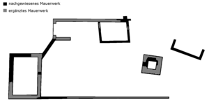
The castle was built in the 11th century on the north-eastern edge of the Iberg. This first system consisted of a main building, a gate and two auxiliary buildings. In addition, the castle had a moat that was supposed to protect it from attacks from the south. Since there are no written records about the castle or its inhabitants, the archaeological investigations are the only clues that provide information about the castle on the Iberg. At the end of the 12th or beginning of the 13th century, a fire destroyed the castle. When it was rebuilt, the facility was expanded with additional trenches and a tower. However, the castle was abandoned before the work was completed. Since the area around the castle was largely owned by the Habsburgs and the Murbach Monastery , it seems likely that the Habsburgs founded the castle.


