Hasleren
| Hasleren | ||
|---|---|---|
|
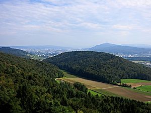
Look at the Hasleren with Zurich in the background from the observation tower Altberg seen from |
||
| height | 583 m above sea level M. | |
| location | Municipality of Geroldswil and Weiningen , Canton of Zurich , Switzerland | |
| Dominance | 0.9 km → Altberggrat | |
| Notch height | 90 m ↓ corridor Harwätti | |
| Coordinates | 674 150 / 253092 | |
|
|
||
| rock | Marl and marl sandstone | |
| particularities | highest point of Geroldswil | |
The Hasleren (formerly Haslern) is 583 m above sea level. M. high, mostly wooded hill in the canton of Zurich and the highest point in the municipality of Geroldswil . It towers prominently over the communities of Geroldswil and Weiningen in the Limmattal and is separated from the Altberg by an ice age meltwater channel. The valley, which is now partially traversed by the Länggenbach , also houses the Langenmoos, a well-preserved spring moor .
There are vineyards on the south-east slope in Weiningen , while the west and south-west slopes in Geroldswil are built on with single-family houses. The Grosse Weiher is nestled between Hasleren and Altberg on the northeast slope above Weiningen .
Scattered all over the hill are boulders that were transported here through the Linth Glacier in the last Ice Age . A part is protected by the regional landscape protection object erratic boulders on the Hasleren plateau . On the south-eastern slope of the hill, near Chatzenstrigel , there is also the regional nature reserve, the dry location Rain .

