Hohbüel
| Hohbüel | ||
|---|---|---|
|
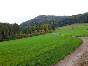
View into the Reppischtal with the Hohbüel |
||
| height | 587 m above sea level M. | |
| location | Urdorf municipality , canton of Zurich , Switzerland | |
| Dominance | 0.085 km → at the municipal boundary to Rudolfstetten-Friedlisberg | |
| Notch height | 7 m ↓ at Oberbuechholz | |
| Coordinates | 673 114 / 247152 | |
|
|
||
| rock | Marl and marl-sandstone | |
| Age of the rock | Tortonium | |
| particularities | highest point in Urdorf | |
The Hohbüel ( 587 m above sea level ) is a wooded hill in the canton of Zurich and the highest point in the municipality of Urdorf . It rises above the Reppischtal and is through this from 581 m above sea level. M. high honeret separated. The Malefizgraben has created a deep ravine on its western slope .
The hill was referred to as Hohlbühl on maps until 1954 . The suffix - büel , which is widespread in Switzerland, means hill or hill.
Geologically, the Hohbüel belongs to the Upper Freshwater Molasse and consists of marl and marl-sandstone.
Web links
Commons : Hohbüel - collection of images, videos and audio files
Individual evidence
- ↑ Geoserver of the Swiss Federal Administration ( information )


