
Sinspelt
| coat of arms | Germany map | |
|---|---|---|

|
Coordinates: 49 ° 58 ' N , 6 ° 19' E |
|
| Basic data | ||
| State : | Rhineland-Palatinate | |
| County : | Eifel district Bitburg-Prüm | |
| Association municipality : | South Eifel | |
| Height : | 278 m above sea level NHN | |
| Area : | 2.44 km 2 | |
| Residents: | 401 (Dec. 31, 2019) | |
| Population density : | 164 inhabitants per km 2 | |
| Postal code : | 54675 | |
| Area code : | 06522 | |
| License plate : | BIT, PRÜ | |
| Community key : | 07 2 32 122 | |
| LOCODE : | DE SPT | |
| Association administration address: | Pestalozzistraße 7 54673 Neuerburg |
|
| Website : | ||
| Local Mayor : | Matthias Kalbusch | |
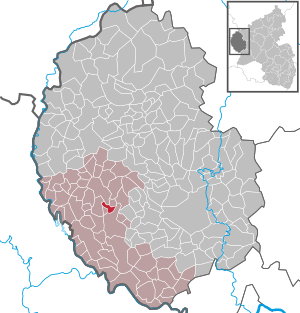
| Location of the local community Sinspelt in the Eifelkreis Bitburg-Prüm | ||
  |
||


;_ehem._M%C3%BChlenanlage_an_der_Enz_a.jpg)
Sinspelt is a municipality in the Eifelkreis Bitburg-Prüm in Rhineland-Palatinate . It belongs to the community of southern Eifel .
geography
The place is located in the West Eifel about 8 km south of the city of Neuerburg in the Enz Valley . The Ehr residential space also belongs to Sinspelt .
history
Sinspelt was a road junction in Roman times. A Roman country house stood here, the "Simonis villa" (Simon's house). The first written mention of the place comes from the year 1435.
Until the end of the 18th century, Sinspelt belonged to the Luxembourg county of Vianden and was assigned to the administration of the Geckler dairy .
In 1794 French revolutionary troops occupied the Austrian Netherlands , to which the Duchy of Luxembourg belonged, and annexed it in October 1795 . From 1795 to 1814 the place belonged to the canton Neuerburg in the department of forests .
In 1815, the former Luxembourg area east of the Sauer and Our was assigned to the Kingdom of Prussia at the Congress of Vienna . 1816 thus came the community Sinspelt to Bitburg in Trier in the Grand Duchy of the Lower Rhine , the 1822 in the Rhine province came up, and was approved by the mayor Outscheid managed. In 1871 the community became part of the Baustert mayor .
After the First World War temporarily occupied by the French , the place has been part of the then newly formed state of Rhineland-Palatinate since 1946.
- Population development
The development of the population of Sinspelt, the values from 1871 to 1987 are based on censuses:
|
|
politics
Municipal council
The council in Sinspelt consists of eight council members, who in the local elections on May 26, 2019 in a majority vote were elected, and the honorary mayor as chairman.
coat of arms
 |
Blazon : "In the blue head of the shield there is a gold tournament collar, underneath it a silver bar split in front in red, behind in gold a joined jug in black." |
| Foundation of the coat of arms: Sinspelt lies on the Enz River and the Radenbach that flows into it. Proximity and abundance of water are reflected in the blue of the shield head. A gold carrier held by three pillars refers to the three storey houses Kooshof, Theishof and Hiwelshof. The two passages in the girder represent the two Enz bridges in the village. On the right flank of the split shield is the red-silver-red of the County of Vianden and on the left flank dominate the gold of the Sinspelter Gutland and a Roman jug made of shards in Black. |
The coat of arms was decided on March 22, 2005 by the local council and approved on December 20, 2005 by the district administration of the Eifelkreis Bitburg-Prüm .
Culture and sights

Buildings
- Filial church Maria Königin from 1959 (Kirchstrasse 1)
- Listed Hofanlage Heyenhof 1804 (in the canal 4)
- Former mill on the Enz
- Coumont farm complex with schnapps distillery
See also: List of cultural monuments in Sinspelt
Regular events
- Annual fair or parish fair on the last weekend in May of the patron saint "Maria, Queen of Peace"
- The “castle burning” or “ hut burning ” to drive out winter. This old custom is observed every year on Sheep Sunday (Schoofssondisch), the first Sunday after Ash Wednesday .
- Traditional rattling or rattling on Good Friday and Holy Saturday
- Jumping procession on Whit Monday
- Car-free cycling day in June along the Enz (Enz Valley Cycle Path )
Green spaces and recreation
- There are seven local hiking trails with a total length of 25 km, marked with white letters on a blue background.
Economy and Infrastructure
Originally mainly agricultural, the place is gradually developing into a residential community through additional buildings .
Web links
- To search for cultural assets of the local community Sinspelt in the database of cultural assets in the Trier region .
Individual evidence
- ↑ State Statistical Office of Rhineland-Palatinate - population status 2019, districts, communities, association communities ( help on this ).
- ↑ State Statistical Office Rhineland-Palatinate (ed.): Official directory of the municipalities and parts of the municipality. Status: January 2019 [ Version 2020 is available. ] . S. 101 (PDF; 3 MB).
- ↑ Entry on place name (Sinspelt) in the database of cultural assets in the Trier region ; Retrieved April 5, 2016.
- ↑ State Statistical Office Rhineland-Palatinate: My village, my city. Retrieved August 7, 2019 .
- ^ The Regional Returning Officer Rhineland-Palatinate: Local elections 2019, city and municipal council elections. Retrieved August 7, 2019 .
- ↑ Sinspelt coat of arms
- ↑ Hüttenbrennen in the Eifel. Retrieved May 8, 2016 .
- ↑ Straw man's day in the Eifel. Retrieved May 16, 2016 .
- ↑ Hut Sunday in the Eifel. Retrieved August 10, 2017 .
- ↑ Customs in Sinpelt. Retrieved May 24, 2016 .
- ↑ Hiking in Sinspelt. Retrieved January 16, 2018 .
Affler | Alsdorf | Altscheid | Ammeldingen on the Our | Ammeldingen near Neuerburg | Bauler | Berkoth | Berscheid | Biesdorf | Bollendorf | Castle | Dauwelshausen | Echternacherbrück | Eisenach | Emmelbaum | Ernzen | Ferschweiler | Fischbach-Oberraden | Geichlingen | Gemünd | Gentingen | Gilzem | Heilbach | Autumn Mill | Holsthum | Hommerdingen | Huts | Hüttingen near Lahr | Irrel | Karlshausen | Kaschenbach | Keppeshausen | Body | Koxhausen | Kruchten | Lahr | Leimbach | Menningen | Mettendorf | Minden | Muxerath | Nasingen | Neuerburg | Niedergeckler | Niederraden | Niederweis | Niehl | Walnut tree | Obergeckler | Peffingen | Plascheid | Prümzurlay | Rodershausen | Roth an der Our | Schankweiler | Log basket | Chafing | Sevenig near Neuerburg | Sinspelt | Überisenbach | Uppershausen | Utscheid | Waldhof-Falkenstein | Wallendorf | Weidingen | Doubt decision