Emmelbaum
| coat of arms | Germany map | |
|---|---|---|

|
Coordinates: 50 ° 3 ' N , 6 ° 16' E |
|
| Basic data | ||
| State : | Rhineland-Palatinate | |
| County : | Eifel district Bitburg-Prüm | |
| Association municipality : | South Eifel | |
| Height : | 515 m above sea level NHN | |
| Area : | 2.69 km 2 | |
| Residents: | 69 (Dec. 31, 2019) | |
| Population density : | 26 inhabitants per km 2 | |
| Postal code : | 54673 | |
| Area code : | 06564 | |
| License plate : | BIT, PRÜ | |
| Community key : | 07 2 32 031 | |
| Association administration address: | Pestalozzistraße 7 54673 Neuerburg |
|
| Website : | ||
| Local Mayor : | Manfred Schreiber | |
| Location of the local community Emmelbaum in the Eifel district Bitburg-Prüm | ||
Emmelbaum is a municipality in the Eifelkreis Bitburg-Prüm in Rhineland-Palatinate . It belongs to the community of southern Eifel .
geography
Emmelbaum is located on the Arzfeld plateau in the West Eifel . The municipality also includes the living spaces house Schmitz, Sachsenhauserhof and Windhof (Wallenbornerhof).
history
The place was first mentioned in 1477 as Emmelbende . Other written sources speak of 1570 Emmelbem and 1664 by Emmel leg .
Until the end of the 18th century, the place belonged to the lordship of Neuerburg in the Duchy of Luxembourg and was subordinate to the administration of the Koxhausen - Leimbach dairy .
In 1794 French revolutionary troops occupied the Austrian Netherlands , to which the Duchy of Luxembourg belonged, and annexed it in October 1795 . From 1795 to 1814 the place belonged to the canton Arzfeld in the department of forests .
In 1815, the former Luxembourg area east of the Sauer and Our was assigned to the Kingdom of Prussia at the Congress of Vienna . 1816 thus came the community Emmelbaum to Bitburg in Trier in the Grand Duchy of the Lower Rhine , which in 1822 Rheinprovinz opened. Emmelbaum was administered by the mayor's office in Ammeldingen .
In 1872 Emmelbaum was almost completely destroyed by fire, only one house was spared. After the First World War temporarily occupied by the French , the place has been part of the then newly formed state of Rhineland-Palatinate since 1946 .
- Population development
The development of the population of Emmelbaum, the values from 1871 to 1987 are based on censuses:
|
|
politics
Municipal council
The local council in Emmelbaum consists of six council members, who were elected by a majority vote in the local elections on May 26, 2019 , and the honorary local mayor as chairman.
coat of arms
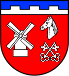
| Blazon : "Under blue over silver by pinnacle cut divided shield head, forming three silver battlements, red, in front a silver windmill, behind over silver crossed keys, beards turned downwards, cut off silver horse head." | |
Culture and sights
- Village chapel on Hauptstrasse 8
- The local fair takes place on the Sunday after May 15th.
Location and traffic
Emmelbaum is located between Arzfeld in the north and Zweifelscheid in the south on Kreisstraße 58 .
Web links
- To search for cultural assets of the local community Emmelbaum in the database of cultural assets in the Trier region .
- Short portrait with a film about Emmelbaum ( memento from February 12, 2013 in the web archive archive.today ) on SWR television
Individual evidence
- ↑ State Statistical Office of Rhineland-Palatinate - population status 2019, districts, communities, association communities ( help on this ).
- ↑ State Statistical Office Rhineland-Palatinate (ed.): Official directory of the municipalities and parts of the municipality. Status: January 2019 [ Version 2020 is available. ] . S. 98 (PDF; 3 MB).
- ↑ State Statistical Office Rhineland-Palatinate: My village, my city. Retrieved August 5, 2019 .
- ^ The Regional Returning Officer Rhineland-Palatinate: Local elections 2019, city and municipal council elections. Retrieved August 5, 2019 .


