Altscheid
| coat of arms | Germany map | |
|---|---|---|

|
Coordinates: 50 ° 1 ′ N , 6 ° 24 ′ E |
|
| Basic data | ||
| State : | Rhineland-Palatinate | |
| County : | Eifel district Bitburg-Prüm | |
| Association municipality : | South Eifel | |
| Height : | 426 m above sea level NHN | |
| Area : | 5.89 km 2 | |
| Residents: | 89 (Dec 31, 2019) | |
| Population density : | 15 inhabitants per km 2 | |
| Postal code : | 54636 | |
| Area code : | 06527 | |
| License plate : | BIT, PRÜ | |
| Community key : | 07 2 32 003 | |
| LOCODE : | DE 4AN | |
| Association administration address: | Pestalozzistraße 7 54673 Neuerburg |
|
| Website : | ||
| Local Mayor : | Lothar Theisen | |
| Location of the local community Altscheid in the Eifelkreis Bitburg-Prüm | ||
Altscheid is a municipality in the Eifelkreis Bitburg-Prüm in Rhineland-Palatinate . It belongs to the community of southern Eifel .
geography
The municipality is partly in the South Eifel Nature Park .
Altscheid also includes the Birkendell residential area and part of the Neumühle hamlet .
Neighboring communities are Weidingen and Wißmannsdorf
history
A church was already mentioned in a register dating from around 1330 (Trier. Archive VIII, p. 14). The visitation protocol from 1570 listed a free curate chapel in "Alschidt", which from 1654 was called a parish church.
Until the end of the 18th century Altscheid belonged to the County of Vianden in the Duchy of Luxembourg .
After 1792 French revolutionary troops occupied the Austrian Netherlands , to which the Duchy of Luxembourg belonged, and annexed it in October 1795 . From 1795 to 1814 the place belonged to the canton Neuerburg in the department of forests .
In 1815, the former Luxembourg area east of the Sauer and Our was assigned to the Kingdom of Prussia at the Congress of Vienna . So that the community came Altscheid 1816 Bitburg in Trier in the Grand Duchy of the Lower Rhine , which in 1822 Rheinprovinz opened.
The nave of the village church was extended by one yoke to the west in 1886. After the First World War temporarily occupied by the French , the place has been part of the state of Rhineland-Palatinate since 1946 .
In 1991, after a thorough renovation, the rectory became the village community center. A year later the parish church was also renovated.
- Population development
The development of the population of Altscheid; the values from 1871 to 1987 are based on censuses:
|
|
Municipal council
The council in Altscheid consists of six council members, who in the local elections on May 26, 2019 in a majority vote were elected, and the honorary mayor as chairman.
Culture and sights
- The parish church of St. Matthias has a choir tower from 1330, the vaulted single-nave nave is from 1760.
- The two-sided courtyard from 1784 at Hauptstraße 24 with a gable-facing residential building has an unusually elaborate entrance design.
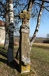
- Road crosses from the 17th and 18th centuries.
See also: List of cultural monuments in Altscheid
Economy and Infrastructure
Around half of the community area is used by seven farms.
Companies
- Biogas plant Altscheid GmbH & Co. KG
traffic
The community is accessed through the state road 9 .
literature
- Literature about Altscheid in the Rhineland-Palatinate state bibliography
- Ernst Wackenroder (arr.): The art monuments of the Bitburg district (= Paul Clemen [Hrsg.]: The art monuments of the Rhine province . Volume 12 / I ). Trier 1983, ISBN 3-88915-006-3 , p. 23 (315 p., With 12 plates and 227 figs. In the text. Reprinted by the Schwann edition, Düsseldorf 1927).
Web links
- To search for cultural assets of the local community Altscheid in the database of cultural assets in the Trier region .
Individual evidence
- ↑ a b State Statistical Office of Rhineland-Palatinate - population status 2019, districts, municipalities, association communities ( help on this ).
- ↑ State Statistical Office Rhineland-Palatinate (ed.): Official directory of the municipalities and parts of the municipality. Status: January 2019 [ Version 2020 is available. ] . S. 98 (PDF; 3 MB).
- ^ Wilhelm Fabricius : Explanations of the historical atlas of the Rhine province, Volume 2: The map of 1789. Hermann Behrend, Bonn 1898, p. 24.
- ↑ Statistical-topographical description of the government district of Trier , Hetzrodt, 1818, s. 42 ( Google Books )
- ↑ State Statistical Office Rhineland-Palatinate: My village, my city. Retrieved August 2, 2019 .
- ^ The State Returning Officer Rhineland-Palatinate: Local elections 2019, individual results. Retrieved August 2, 2019 .
- ↑ Altscheid biogas plant. (PDF) Retrieved November 30, 2017 .


