
Rodershausen
| coat of arms | Germany map | |
|---|---|---|

|
Coordinates: 50 ° 0 ′ N , 6 ° 12 ′ E |
|
| Basic data | ||
| State : | Rhineland-Palatinate | |
| County : | Eifel district Bitburg-Prüm | |
| Association municipality : | South Eifel | |
| Height : | 500 m above sea level NHN | |
| Area : | 5.37 km 2 | |
| Residents: | 162 (Dec. 31, 2019) | |
| Population density : | 30 inhabitants per km 2 | |
| Postal code : | 54673 | |
| Area code : | 06524 | |
| License plate : | BIT, PRÜ | |
| Community key : | 07 2 32 110 | |
| Association administration address: | Pestalozzistraße 7 54673 Neuerburg |
|
| Website : | ||
| Local Mayor : | Matthias Lorig | |
| Location of the local community Rodershausen in the Eifelkreis Bitburg-Prüm | ||
  |
||


Rodershausen is a municipality in the Eifelkreis Bitburg-Prüm in Rhineland-Palatinate . It belongs to the community of southern Eifel .
geography
Rodershausen is located in the South Eifel nature reserve . The community also includes the Gaymühle and Grünhof residential areas.
history
A chapel in Ruterszhusen was listed in a visitation report from 1570.
Until the end of the 18th century, the place belonged to the County of Vianden in the Duchy of Luxembourg and was subordinate to the Karlshausen dairy . As a result of the French Revolutionary Wars , the Austrian Netherlands , to which Luxembourg then belonged, was annexed to the French state in 1795 . Rodershausen was assigned to the canton of Neuerburg in the department of forests .
As a result of the resolutions at the Congress of Vienna , the former Luxembourg area east of the Sauer and Our rivers became part of the Kingdom of Prussia in 1815 . Rodershausen belonged to the mayor's office of Karlshausen in the Bitburg district, newly established in 1816, in the Trier administrative district , which was part of the Rhine province from 1822 .
After the First World War , the area belonged to the French part of the Allied occupation of the Rhineland . After the Second World War , Rodershausen became part of the then newly formed state of Rhineland-Palatinate within the French occupation zone .
- Population development
The development of the population of Rodershausen; the values from 1871 to 1987 are based on censuses:
|
|
Municipal council
The local council in Rodershausen consists of six council members who were elected in the local elections on May 26, 2019 in a majority vote, and the honorary local mayor as chairman.
coat of arms
|
|
Blazon : "Argent, a travel bag with carrying strap diagonally crossed with a black walking stick topped with
black hat showing a golden shell, accompanied on both sides by a red double flan. " |
| Foundation of the coat of arms: Rodershausen belonged to the county of Vianden at the time of the old empire. The colors red and silver indicate this affiliation. The patron saint of the parish of Rodershausen is the holy apostle James the Elder, whose symbols are a travel bag, a hat with a wide brim and a golden shell and a walking stick. |
Culture and sights
_-_geo.hlipp.de_-_23432.jpg)
Buildings
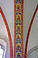
- The church of St. Jakobus Major was built in 1896 on the site of the previous building in neo-Gothic style with a western tower and three-sided choir and renovated in 1975. It has been equipped with a Keates organ from 1920 since 2006 .

St. James (1896)

High altar
Strap bow

St. James the Elder Ä.

Keates organ (1920)
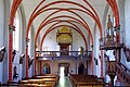
Interior, organ loft
_02.jpg)
_08.jpg)
_32.jpg)
_37.jpg)
_44.jpg)
_20.jpg)
- Path chapel from 1910
See also: List of cultural monuments in Rodershausen
Green spaces and recreation
- Hiking trails in and around Rodershausen
Regular events
- Annual fair or parish fair is celebrated on the last weekend in May.
- Hut burning on the first weekend after Ash Wednesday (so-called Scheef Sunday)
literature
- Ernst Wackenroder (arr.): The art monuments of the Bitburg district (= Paul Clemen [Hrsg.]: The art monuments of the Rhine province . Volume 12 / I ). Trier 1983, ISBN 3-88915-006-3 , p. 246 (315 p., With 12 plates and 227 figs. In the text. Reprinted by the Schwann edition, Düsseldorf 1927).
Web links
- To search for cultural assets of the local community Rodershausen in the database of cultural assets in the Trier region .
Individual evidence
- ↑ State Statistical Office of Rhineland-Palatinate - population status 2019, districts, communities, association communities ( help on this ).
- ↑ State Statistical Office Rhineland-Palatinate (ed.): Official directory of the municipalities and parts of the municipality. Status: January 2019 [ Version 2020 is available. ] . S. 100 f . (PDF; 3 MB).
- ↑ State Statistical Office Rhineland-Palatinate: My village, my city. Retrieved August 7, 2019 .
- ^ The Regional Returning Officer Rhineland-Palatinate: Local elections 2019, city and municipal council elections. Retrieved August 7, 2019 .
- ↑ Rodershausen coat of arms
- ↑ Rodershausen - Sevenig - Karlshausen - Koxhausen hiking route. Retrieved July 14, 2018 .
- ↑ Matthiasweg hiking trail. Retrieved July 14, 2018 .
- ↑ Hüttenbrennen in the Eifel. Retrieved May 1, 2016 .
- ↑ Hut Sunday in the Eifel. Retrieved August 10, 2017 .
Affler | Alsdorf | Altscheid | Ammeldingen on the Our | Ammeldingen near Neuerburg | Bauler | Berkoth | Berscheid | Biesdorf | Bollendorf | Castle | Dauwelshausen | Echternacherbrück | Eisenach | Emmelbaum | Ernzen | Ferschweiler | Fischbach-Oberraden | Geichlingen | Gemünd | Gentingen | Gilzem | Heilbach | Autumn Mill | Holsthum | Hommerdingen | Huts | Hüttingen near Lahr | Irrel | Karlshausen | Kaschenbach | Keppeshausen | Body | Koxhausen | Kruchten | Lahr | Leimbach | Menningen | Mettendorf | Minden | Muxerath | Nasingen | Neuerburg | Niedergeckler | Niederraden | Niederweis | Niehl | Walnut tree | Obergeckler | Peffingen | Plascheid | Prümzurlay | Rodershausen | Roth an der Our | Schankweiler | Log basket | Chafing | Sevenig near Neuerburg | Sinspelt | Überisenbach | Uppershausen | Utscheid | Waldhof-Falkenstein | Wallendorf | Weidingen | Doubt decision