
Roth an der Our
| coat of arms | Germany map | |
|---|---|---|

|
Coordinates: 49 ° 55 ' N , 6 ° 14' E |
|
| Basic data | ||
| State : | Rhineland-Palatinate | |
| County : | Eifel district Bitburg-Prüm | |
| Association municipality : | South Eifel | |
| Height : | 240 m above sea level NHN | |
| Area : | 1.89 km 2 | |
| Residents: | 209 (Dec. 31, 2019) | |
| Population density : | 111 inhabitants per km 2 | |
| Postal code : | 54675 | |
| Area code : | 06566 | |
| License plate : | BIT, PRÜ | |
| Community key : | 07 2 32 112 | |
| LOCODE : | DE RD3 | |
| Association administration address: | Pestalozzistraße 7 54673 Neuerburg |
|
| Website : | ||
| Local Mayor : | Herbert Fischels | |
| Location of the local community Roth an der Our in the Eifel district of Bitburg-Prüm | ||
  |
||


Roth an der Our is a municipality in the Eifelkreis Bitburg-Prüm in Rhineland-Palatinate . It belongs to the community of southern Eifel .
geography
The municipality is located in a valley in the German-Luxembourgish Nature Park immediately east of the state border with Luxembourg . The border is formed by the Our running west of Roth . The federal highway 50 begins in Roth an der Our and leads from there to Bitburg .
The bridge over the Our leads to Bettel in the south of Luxembourg (municipality of Tandel ) and to Vianden, two kilometers to the north . On the German side of the border, Gentingen is 5 km south , Körperich and Obersgegen are 4 km to the east , and Bauler is about 7 km to the north .
The Sonnenhof and Schloßmühle residential areas also belong to Roth an der Our .
history
In 1154 the place was mentioned for the first time in a certificate of ownership by Pope Hadrian IV for the Simeonstift in Trier . Back then it was still a larger estate . The fact that Roth was the seat of a parish before this date and that the Romanesque basilica is said to have been founded by St. Willibrord von Echternach (8th century).
The importance of Roth rose by leaps and bounds around 1220 when the seat of a commander of the Knights Templar was established there. After the order of the Knights Templar was abolished around 1314, the coming went to the Order of St. John , which was later also called the " Order of Malta " because its headquarters were on the island of Malta from 1530 onwards.
Commander of Roth:
- Dyon around 1248
- Hubert von Perault around 1261
Today's Roth Castle goes back largely to a new building from 1733, which became necessary after the original buildings had become dilapidated. The place came under the control of the counts and later dukes of Luxembourg in the late 13th century and, like the duchy , experienced Burgundian , Spanish and Austrian rule. With the occupation of the Austrian Netherlands (1794), to which Luxembourg belonged at that time, by French revolutionary troops , the place became French in 1795 and belonged to the Forests Department until 1814 . In 1815 he was separated from the previous Duchy of Luxembourg at the Congress of Vienna and assigned to the Kingdom of Prussia . As a result of the Second World War , Luxembourg raised claims, among other things, to the community of Roth and the adjacent Kammerwald as compensation for war damage suffered . In 1949 the municipality was administered by Luxembourg for a few years and belonged to the canton of Vianden . The claim was not officially abandoned until 1959 against other reparation payments.
On January 1, 1971, the community received the part of its name "an der Our".
- Population development
The development of the population of Roth an der Our, the values from 1871 to 1987 are based on censuses:
|
|
politics
Municipal council
The local council in Roth an der Our consists of six council members, who were elected in a personalized proportional representation in the local elections on May 26, 2019 , and the honorary local mayor as chairman.
coat of arms
|
|
Blazon : "Three white Maltese crosses in red." |
| Founding of the coat of arms: Roth was a former temple lord, then a Johanniter settlement. The Johanniter Ordenskirche and Commende are still there today. |
Culture and sights
7.JPG)
Buildings
-
Church of St. Peter , built in the first half of the 12th century. Of the oldest components, only the choir is left . In the 13th century, a three-aisled basilica was built on the remains of the original church. Rebuilt again in 1466, the wooden roof in particular was replaced by a vault. Gothic and Romanesque style elements have been mixed here (as in the church in Echternach ). After the Second World War, the damage was repaired and the destroyed parts were restored in 1962.
- On the north side, between the church and the immediately adjacent cemetery, there is a stone plague cross erected in 1632 .
- On the east side between the apse and the main choir, the so-called Rother man can be seen, a figure with short raised arms. It is not certain whether it is supposed to represent the risen Christ.
- Roth Castle . The former Commandery / Coming of the Templars was first mentioned in a document in 1248. The oldest components of the complex are the cellars (13th century), the stair tower (16th century) and the gate building (17th century) as well as parts of the curtain wall. Most of the castle was rebuilt in 1733 under the Knights of St. John / Maltese and rebuilt in 1958 after the destruction of the World War. The facility has been privately owned since 1797.
See also: List of cultural monuments in Roth an der Our
Green spaces and recreation
- Royal oak in the chamber forest . It has a height of 33 m and a circumference of 5.20 m. The age of the Maoderkoos , the mother oak , is estimated to be over 450 years. A lightning rod protruding into the tops is supposed to protect them during thunderstorms.
- Willibrordlinde. It stands at the entrance to the churchyard and is estimated to be around 800 years old. However, only the trunk is left up to about eye level, on which new shoots grew.
- There are numerous hiking trails in and around Roth ad Our
See also: List of natural monuments in Roth an der Our
Regular events
- Every year on the first weekend in July, the "Eifler Flea Market" takes place.
- Annual fair or parish fair is celebrated on the second weekend in September.
- Every second weekend in August, people from Roth and the surrounding area meet for an "equestrian festival".

Roth Castle, aerial photo (2017)
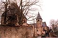
Roth, church and gate tower

Red male

Mother and king oak in the Kammerwald

St. Peter's Church


literature
- Ernst Wackenroder (edit.): The art monuments of the Bitburg district . Ed .: Paul Clemen (= Die Kunstdenkmäler der Rheinprovinz . Volume 12 / I ). Trier 1983, ISBN 3-88915-006-3 , p. 248–260 (315 p., With 12 plates and 227 illustrations in the text. Reprinted by the Schwann edition, Düsseldorf 1927).
- Josef Arnoldi: Order church with commandery in Roth an der Our. 1964.
- Christoph Summa: How today's German-Luxembourg border in the Sauer and Our area came about. In: Regional history quarterly papers. Issue 2, 1980.
- G. Bartz: Problems and aspects of the German-Luxembourg border survey 1984. Trier 2001.
- A. Grosbusch: La question des réparations dans l'opinion luxembourgeoise 1945–1949. In: Hémecht. Journal of Luxembourg History. Issue 4, Luxembourg, pp. 569-591.
- D.-E. Khan: The German state borders. Legal history basics and open legal questions. Tuebingen 2004.
- M. Lengerau: Les frontières allemandes (1919–1989), Frontières d'Allemagne et en Allemagne: Aspects territoriaux de la question Allemande. Bern 1990, p. 70.
- C. Summa: How today's German-Luxembourg border in the area of the Sauer and Our came into being. In: Regional history quarterly papers. Issue 2, Trier 1980, pp. 62-81.
Web links
- To search for cultural assets of the local community Roth an der Our in the database of cultural assets in the Trier region .
- Ordinance No. 212 of the French High Command on border corrections (original French and German text)
- GA079 1949: Kammerwald. ( Memento from February 19, 2013 in the web archive archive.today )
- Portrait of Roth ad Our, SWR 2016
Individual evidence
- ↑ State Statistical Office of Rhineland-Palatinate - population status 2019, districts, communities, association communities ( help on this ).
- ↑ State Statistical Office Rhineland-Palatinate (ed.): Official directory of the municipalities and parts of the municipality. Status: January 2019 [ Version 2020 is available. ] . S. 101 (PDF; 3 MB).
- ↑ State Statistical Office Rhineland-Palatinate: Regional data.
- ^ The Regional Returning Officer Rhineland-Palatinate: Local elections 2019, city and municipal council elections. Retrieved August 7, 2019 .
- ^ Coat of arms of Rot ad Our.
- ↑ Roth ad Our hiking route. Retrieved January 26, 2018 .
Affler | Alsdorf | Altscheid | Ammeldingen on the Our | Ammeldingen near Neuerburg | Bauler | Berkoth | Berscheid | Biesdorf | Bollendorf | Castle | Dauwelshausen | Echternacherbrück | Eisenach | Emmelbaum | Ernzen | Ferschweiler | Fischbach-Oberraden | Geichlingen | Gemünd | Gentingen | Gilzem | Heilbach | Autumn Mill | Holsthum | Hommerdingen | Huts | Hüttingen near Lahr | Irrel | Karlshausen | Kaschenbach | Keppeshausen | Body | Koxhausen | Kruchten | Lahr | Leimbach | Menningen | Mettendorf | Minden | Muxerath | Nasingen | Neuerburg | Niedergeckler | Niederraden | Niederweis | Niehl | Walnut tree | Obergeckler | Peffingen | Plascheid | Prümzurlay | Rodershausen | Roth an der Our | Schankweiler | Log basket | Chafing | Sevenig near Neuerburg | Sinspelt | Überisenbach | Uppershausen | Utscheid | Waldhof-Falkenstein | Wallendorf | Weidingen | Doubt decision