
Begging (tandel)
|
Begging ( German )
community Tandel
|
||
|---|---|---|
| Coordinates : | 49 ° 55 ' N , 6 ° 14' E | |
| Residents : | 382 (Aug 2, 2018) | |
| Postal code : | 9452 | |
Location of Bettel in Luxembourg
|
||
 Bettel (seen from Roth an der Our)
|
||

_001.jpg)
Bettel is a village in the municipality of Tandel in the canton of Vianden in Luxembourg .
location
Bettel is located directly on the German-Luxembourg border, opposite the German town of Roth an der Our . The Bettelerbach rises near Fuhren and flows into the Our at Bettel.
history
The place was mentioned in a document in 1322 when Walther von Clervaux entrusted the Bittelde farm to Count Heinrich von Vianden for 150 pounds of small black Turnesians . In the middle of the 19th century, Bettel had 133 inhabitants and consisted of 17 houses. The Saint-Hubert church was a branch church belonging to Fouhren .
Bettel was on the former line of the narrow-gauge railway Diekirch-Vianden . Today the former railway line between Fouhren and Vianden is partly used as a cycle path.
Buildings
The Bettel bridge connects Germany (Roth an der Our) with Luxembourg (Bettel). It leads over the Our and is the meeting point of the roads N10 (Luxembourgish) and K5 (German). The current bridge from 1955 replaces the structure from 1874, which was blown up by the Wehrmacht on September 12, 1944 while retreating. It is 42 m long and nine meters wide.

St. Hubert Church
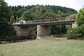
Bettel bridge over the Our
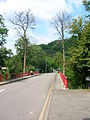
Bridge to Bettel

Former Bettel train station


Web links
Individual evidence
- ↑ La commune en chiffres. In: Website of the municipality of Tandel. Retrieved November 15, 2018 .
- ^ Philippe Vandermaelen, François-Joseph Meisser: Dictionnaire géographique , Etablissement Géographique, 1838, page 54
- ^ Johann Friedrich Schannat, Georg Baersch: The cities and towns of the Eifel and their surroundings: topographically and historically described , Mayer Verlag, 1855, page 233

Bastendorf | Begging | Brandenburg | Drove | Landscheid | Longsdorf | Seltz | Tandel | Walsdorf