Landscheid (Tandel)
|
Landscheid ( German ) Laaschent ( lux. ) community Tandel
|
||
|---|---|---|
| Coordinates : | 49 ° 55 ' N , 6 ° 8' E | |
| Residents : | 88 (Aug 2, 2018) | |
| Postal code : | 9457 | |
|
Location of Landscheid in Luxembourg
|
||
|
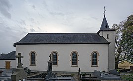
Filial church Heilig Kreuz
|
||
Landscheid ( Luxembourgish Laaschent ) is a village in the municipality of Tandel in the canton of Vianden in Luxembourg .
location
Landscheid lies on a ridge and is surrounded by forest. The CR 352 runs through the town. The only neighboring town is in the south of Brandenburg .
General
Landscheid has belonged to the municipality of Tandel since January 1, 2006, previously the village was part of Bastendorf.
In the small, rural village is the Holy Cross Church in the center, which is a branch church of Bastendorf. In front of the church are two 250 year old linden trees , which are called Willibrordus linden trees . According to the local legend, St. Willibrord planted the two linden trees on a mission trip, but this cannot be due to their too young age.
Individual evidence
- ↑ La commune en chiffres. In: Website of the municipality of Tandel. Retrieved December 27, 2018 .


